|
 |
|
||||
|
By
Wikipedia,
Air traffic control (ATC) is a service provided by ground-based controllers who direct aircraft on the ground and in the air. The primary purpose of ATC systems worldwide is to separate aircraft to prevent collisions, to organize and expedite the flow of traffic, and to provide information and other support for pilots when able. In some countries, ATC may also play a security or defense role (as in the United States), or be run entirely by the military (as in Brazil). Preventing collisions is referred to as separation, which is a term used to prevent aircraft from coming too close to each other by use of lateral, vertical and longitudinal separation minima; many aircraft now have collision avoidance systems installed to act as a backup to ATC observation and instructions. In addition to its primary function, the ATC can provide additional services such as providing information to pilots, weather and navigation information and NOTAMs (Notices to Airmen). In many countries, ATC services are provided throughout the majority of airspace, and its services are available to all users (private, military, and commercial). When controllers are responsible for separating some or all aircraft, such airspace is called "controlled airspace" in contrast to "uncontrolled airspace" where aircraft may fly without the use of the air traffic control system. Depending on the type of flight and the class of airspace, ATC may issue instructions that pilots are required to follow, or merely flight information (in some countries known as advisories) to assist pilots operating in the airspace. In all cases, however, the pilot in command has final responsibility for the safety of the flight, and may deviate from ATC instructions in an emergency. Although the native language for a region is normally used, English must be used on request, as required by the International Civil Aviation Organization (ICAO). HistoryIn 1919, the International Commission for Air Navigation (ICAN) was created to develop General Rules for Air Traffic. Its rules and procedures were applied in most countries where aircraft operated. The United States did not sign the ICAN Convention, but later developed its own set of air traffic rules after passage of the Air Commerce Act of 1926. This legislation authorized the Department of Commerce to establish air traffic rules for the navigation, protection, and identification of aircraft, including rules as to safe altitudes of flight and rules for the prevention of collisions between vessels and aircraft. The first rules were brief and basic. For example, pilots were told not to begin their takeoff until there is no risk of collision with landing aircraft and until preceding aircraft are clear of the field. As traffic increased, some airport operators realized that such general rules were not enough to prevent collisions. They began to provide a form of air traffic control (ATC) based on visual signals. Early controllers, like Archie League (one of the first system’s flagmen), stood on the field, waving flags to communicate with pilots. As more aircraft were fitted for radio communication, radio-equipped airport traffic control towers began to replace the flagmen. In 1930, the first radio-equipped control tower in the United States began operating at the Cleveland Municipal Airport. By 1935, about 20 radio control towers were operating. Increases in the number of flights created a need for ATC that was not just confined to airport areas but also extended out along the airways. In 1935, the principal airlines using the Chicago, Cleveland, and Newark airports agreed to coordinate the handling of airline traffic between those cities. In December, the first Airway Traffic Control Center opened at Newark, New Jersey. Additional centers at Chicago and Cleveland followed in 1936. The early controllers tracked the position of planes using maps and blackboards and little boat-shaped weights that came to be called shrimp boats. They had no direct radio link with aircraft but used telephones to stay in touch with airline dispatchers, airway radio operators, and airport traffic controllers. In July 1936, en route ATC became a federal responsibility and the first appropriation of $175,000 was made ($2,665,960 today). The Federal Government provided airway traffic control service, but local government authorities where the towers were located continued to operate those facilities. In 1941, Congress appropriated funds for the Civil Aeronautics Administration (CAA) to construct and operate ATC towers, and soon the CAA began taking over operations at the first of these towers, with their number growing to 115 by 1944. In the postwar era, ATC at most airports was eventually to become a permanent federal responsibility. In response to wartime needs, the CAA also greatly expanded its en route air traffic control system. The postwar years saw the beginning of a revolutionary development in ATC, the introduction of radar, a system that uses radio waves to detect distant objects. Originally developed by the British for military defense, this new technology allowed controllers to see the position of aircraft tracked on video displays. In 1946, the CAA unveiled an experimental radar-equipped tower for control of civil flights. By 1952, the agency had begun its first routine use of radar for approach and departure control. Four years later, it placed a large order for long-range radars for use in en route ATC. In 1960, the FAA began successful testing of a system under which flights in certain positive control areas were required to carry a radar beacon, called a transponder that identified the aircraft and helped to improve radar performance. Pilots in this airspace were also required to fly on instruments regardless of the weather and to remain in contact with controllers. Under these conditions, controllers were able to reduce the separation between aircraft by as much as half the standard distance. For many years, pilots had negotiated a complicated maze of airways. In September 1964, the FAA instituted two layers of airways, one from 1,000 to 18,000 feet (305 to 5,486 meters) above ground and the second from 18,000 to 45,000 feet (13,716 m). It also standardized aircraft instrument settings and navigation checkpoints to reduce the controllers' workload. From 1965 to 1975, the FAA developed complex computer systems that would replace the plastic markers for tracking aircraft thereby modernizing the National Airspace System. Controllers could now view information sent by aircraft transponders to form alphanumeric symbols on a simulated three dimensional radar screen. The system allowed controllers to focus on providing separation by automating complex tasks. The FAA established a Central Flow Control Facility in April 1970, to prevent clusters of congestion from disrupting the nationwide air traffic flow. This type of ATC became increasingly sophisticated and important, and in 1994, the FAA opened a new Air Traffic Control System Command Center with advanced equipment. In January 1982, the FAA unveiled the National Airspace System (NAS) Plan. The plan called for modernized flight service stations, more advanced systems for ATC, and improvements in ground-to-air surveillance and communication. Better computers and software were developed, air route traffic control centers were consolidated, and the number of flight service stations reduced. New Doppler Radars and better transponders complemented automatic, radio broadcasts of surface and flight conditions. In July 1988, the FAA selected IBM to develop the new multi-billion-dollar Advanced Automation System (AAS) for the Nation's en route ATC centers. AAS would include controller workstations, called "sector suites," that would incorporate new display, communications and processing capabilities. The system had upgraded hardware enabling increased automation of complex tasks. In December 1993, the FAA reviewed its order for the planned AAS. IBM was far behind schedule and had major cost overruns. In 1994 the FAA simplified its needs and picked new contractors. The revised modernization program continued under various project names. In 1999, controllers began their first use of an early version of the Standard Terminal Automation Replacement System, which included new displays and capabilities for approach control facilities. During the following year, FAA completed deployment of the Display System Replacement, providing more efficient workstations for en route controllers. In 1994, the concept of Free Flight was introduced. It might eventually allow pilots to use on board instruments and electronics to maintain a safe distance between planes and to reduce their reliance on ground controllers. Full implementation of this concept would involve technology that made use of the Global Positioning System to help track the position of aircraft. In 1998, the FAA and industry began applying some of the early capabilities developed by the Free Flight program. Current studies to upgrade ATC include the Communication, Navigation and Surveillance for Air Traffic Management System that relies on the most advanced aircraft transponder, a global navigation satellite system, and ultra-precise radar. Tests are underway to design new cockpit displays that will allow pilots to better control their aircraft by combining as many as 32 types of information about traffic, weather, and hazards. Airport control
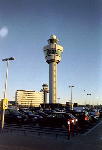
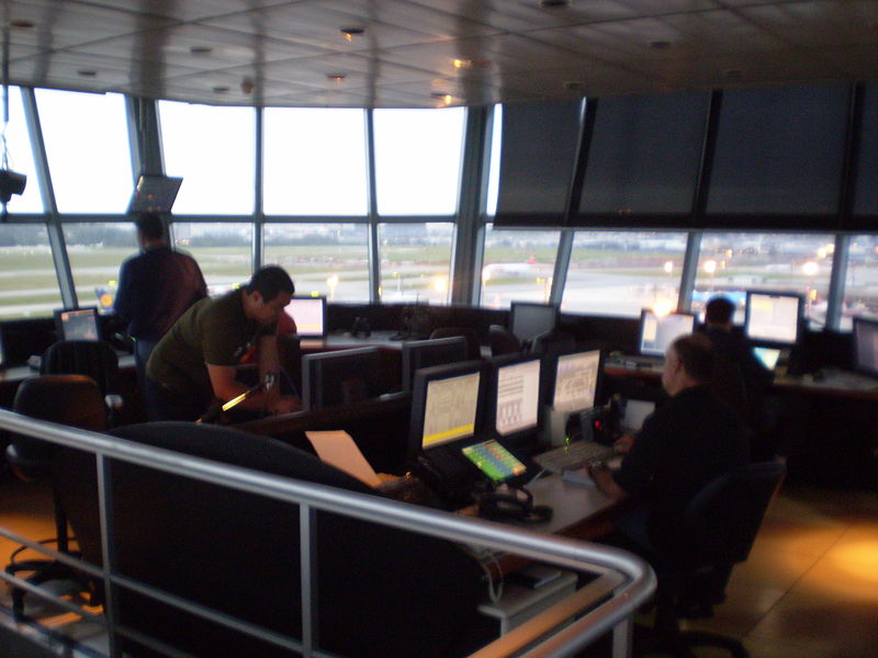
The primary method of controlling the immediate airport environment is visual observation from the airport traffic control tower (ATCT). The ATCT is a tall, windowed structure located on the airport grounds. Aerodrome or Tower controllers are responsible for the separation and efficient movement of aircraft and vehicles operating on the taxiways and runways of the airport itself, and aircraft in the air near the airport, generally 2 to 5 nautical miles (3.7 to 9.2 km) depending on the airport procedures. Radar displays are also available to controllers at some airports. Controllers may use a radar system called Secondary Surveillance Radar for airborne traffic approaching and departing. These displays include a map of the area, the position of various aircraft, and data tags that include aircraft identification, speed, heading, and other information described in local procedures. The areas of responsibility for ATCT controllers fall into three general operational disciplines; Local Control or Air Control, Ground Control, and Flight Data/Clearance Delivery -- other categories, such as Apron Control or Ground Movement Planner, may exist at extremely busy airports. While each ATCT may have unique airport-specific procedures, such as multiple teams of controllers ('crews') at major or complex airports with multiple runways, the following provides a general concept of the delegation of responsibilities within the ATCT environment. Ground ControlGround Control (sometimes known as Ground Movement Control abbreviated to GMC or Surface Movement Control abbreviated to SMC) is responsible for the airport "movement" areas, as well as areas not released to the airlines or other users. This generally includes all taxiways, inactive runways, holding areas, and some transitional aprons or intersections where aircraft arrive, having vacated the runway or departure gate. Exact areas and control responsibilities are clearly defined in local documents and agreements at each airport. Any aircraft, vehicle, or person walking or working in these areas is required to have clearance from Ground Control. This is normally done via VHF/UHF radio, but there may be special cases where other processes are used. Most aircraft and airside vehicles have radios. Aircraft or vehicles without radios must respond to ATC instructions via aviation light signals or else be led by vehicles with radios. People working on the airport surface normally have a communications link through which they can communicate with Ground Control, commonly either by handheld radio or even cell phone. Ground Control is vital to the smooth operation of the airport, because this position impacts the sequencing of departure aircraft, affecting the safety and efficiency of the airport's operation. Some busier airports have Surface Movement Radar (SMR), such as, ASDE-3, AMASS or ASDE-X, designed to display aircraft and vehicles on the ground. These are used by Ground Control as an additional tool to control ground traffic, particularly at night or in poor visibility. There are a wide range of capabilities on these systems as they are being modernized. Older systems will display a map of the airport and the target. Newer systems include the capability to display higher quality mapping, radar target, data blocks, and safety alerts, and to interface with other systems such as digital flight strips. Local Control or Air ControlLocal Control (known to pilots as "Tower" or "Tower Control") is responsible for the active runway surfaces. Local Control clears aircraft for takeoff or landing, ensuring that prescribed runway separation will exist at all times. If Local Control detects any unsafe condition, a landing aircraft may be told to "go-around" and be re-sequenced into the landing pattern by the approach or terminal area controller. Within the ATCT, a highly disciplined communications process between Local Control and Ground Control is an absolute necessity. Ground Control must request and gain approval from Local Control to cross any active runway with any aircraft or vehicle. Likewise, Local Control must ensure that Ground Control is aware of any operations that will impact the taxiways, and work with the approach radar controllers to create "holes" or "gaps" in the arrival traffic to allow taxiing traffic to cross runways and to allow departing aircraft to take off. Crew Resource Management (CRM) procedures are often used to ensure this communication process is efficient and clear, although this is not as prevalent as CRM for pilots. Flight Data / Clearance DeliveryClearance Delivery is the position that issues route clearances to aircraft, typically before they commence taxiing. These contain details of the route that the aircraft is expected to fly after departure. Clearance Delivery or, at busy airports, the Traffic Management Coordinator (TMC) will, if necessary, coordinate with the en route center and national command center or flow control to obtain releases for aircraft. Often, however, such releases are given automatically or are controlled by local agreements allowing "free-flow" departures. When weather or extremely high demand for a certain airport or airspace becomes a factor, there may be ground "stops" (or "slot delays") or re-routes may be necessary to ensure the system does not get overloaded. The primary responsibility of Clearance Delivery is to ensure that the aircraft have the proper route and slot time. This information is also coordinated with the en route center and Ground Control in order to ensure that the aircraft reaches the runway in time to meet the slot time provided by the command center. At some airports, Clearance Delivery also plans aircraft pushbacks and engine starts, in which case it is known as the Ground Movement Planner (GMP): this position is particularly important at heavily congested airports to prevent taxiway and apron gridlock. Flight Data (which is routinely combined with Clearance Delivery) is the position that is responsible for ensuring that both controllers and pilots have the most current information: pertinent weather changes, outages, airport ground delays/ground stops, runway closures, etc. Flight Data may inform the pilots using a recorded continuous loop on a specific frequency known as the Automatic Terminal Information Service (ATIS). Approach and terminal controlMany airports have a radar control facility that is associated with the airport. In most countries, this is referred to as Approach or Terminal Control; in the U.S., it is often still referred to as a TRACON (Terminal Radar Approach CONtrol) facility. While every airport varies, terminal controllers usually handle traffic in a 30 to 50 nautical mile (56 to 93 km) radius from the airport. Where there are many busy airports in close proximity, one single terminal control may service all the airports. The actual airspace boundaries and altitudes assigned to a terminal control are based on factors such as traffic flows, neighboring airports and terrain, and vary widely from airport to airport: a large and complex example is the London Terminal Control Centre which controls traffic for five main London airports up to 20,000 feet (6,100 m) and out to 100 nautical miles (190 km). Terminal controllers are responsible for providing all ATC services within their airspace. Traffic flow is broadly divided into departures, arrivals, and overflights. As aircraft move in and out of the terminal airspace, they are handed off to the next appropriate control facility (a control tower, an en-route control facility, or a bordering terminal or approach control). Terminal control is responsible for ensuring that aircraft are at an appropriate altitude when they are handed off, and that aircraft arrive at a suitable rate for landing. Not all airports have a radar approach or terminal control available. In this case, the en-route center or a neighboring terminal or approach control may co-ordinate directly with the tower on the airport and vector inbound aircraft to a position from where they can land visually. At some of these airports, the tower may provide a non-radar procedural approach service to arriving aircraft handed over from a radar unit before they are visual to land. Some units also have a dedicated approach unit which can provide the procedural approach service either all the time or for any periods of radar outage for any reason. En-route, center, or area control
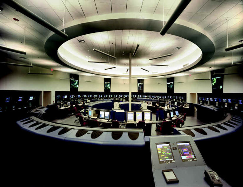
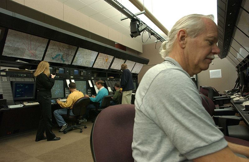
ATC provides services to aircraft in flight between airports as well. Pilots fly under one of two sets of rules for separation: Visual Flight Rules (VFR) or Instrument Flight Rules (IFR). Air traffic controllers have different responsibilities to aircraft operating under the different sets of rules. While IFR flights are under positive control, in the US VFR pilots can request flight following, which provides traffic advisory services on a time permitting basis and may also provide assistance in avoiding areas of weather and flight restrictions. En-route air traffic controllers issue clearances and instructions for airborne aircraft, and pilots are required to comply with these instructions. En-route controllers also provide air traffic control services to many smaller airports around the country, including clearance off of the ground and clearance for approach to an airport. Controllers adhere to a set of separation standards that define the minimum distance allowed between aircraft. These distances vary depending on the equipment and procedures used in providing ATC services. General characteristicsEn-route air traffic controllers work in facilities called Area Control Centers, each of which is commonly referred to as a "Center". The United States uses the equivalent term Air Route Traffic Control Center (ARTCC). Each center is responsible for many thousands of square miles of airspace (known as a Flight Information Region) and for the airports within that airspace. Centers control IFR aircraft from the time they depart from an airport or terminal area's airspace to the time they arrive at another airport or terminal area's airspace. Centers may also "pick up" VFR aircraft that are already airborne and integrate them into the IFR system. These aircraft must, however, remain VFR until the Center provides a clearance. Center controllers are responsible for climbing the aircraft to their requested altitude while, at the same time, ensuring that the aircraft is properly separated from all other aircraft in the immediate area. Additionally, the aircraft must be placed in a flow consistent with the aircraft's route of flight. This effort is complicated by crossing traffic, severe weather, special missions that require large airspace allocations, and traffic density. When the aircraft approaches its destination, the center is responsible for meeting altitude restrictions by specific points, as well as providing many destination airports with a traffic flow, which prohibits all of the arrivals being "bunched together". These "flow restrictions" often begin in the middle of the route, as controllers will position aircraft landing in the same destination so that when the aircraft are close to their destination they are sequenced. As an aircraft reaches the boundary of a Center's control area it is "handed off" or "handed over" to the next Area Control Center. In some cases this "hand-off" process involves a transfer of identification and details between controllers so that air traffic control services can be provided in a seamless manner; in other cases local agreements may allow "silent handovers" such that the receiving center does not require any co-ordination if traffic is presented in an agreed manner. After the hand-off, the aircraft is given a frequency change and begins talking to the next controller. This process continues until the aircraft is handed off to a terminal controller ("approach"). Radar coverageSince centers control a large airspace area, they will typically use long range radar that has the capability, at higher altitudes, to see aircraft within 200 nautical miles (370 km) of the radar antenna. They may also use TRACON radar data to control when it provides a better "picture" of the traffic or when it can fill in a portion of the area not covered by the long range radar. In the U.S. system, at higher altitudes, over 90% of the U.S. airspace is covered by radar and often by multiple radar systems; however, coverage may be inconsistent at lower altitudes used by unpressurized aircraft due to high terrain or distance from radar facilities. A center may require numerous radar systems to cover the airspace assigned to them, and may also rely on pilot position reports from aircraft flying below the floor of radar coverage. This results in a large amount of data being available to the controller. To address this, automation systems have been designed that consolidate the radar data for the controller. This consolidation includes eliminating duplicate radar returns, ensuring the best radar for each geographical area is providing the data, and displaying the data in an effective format. Centers also exercise control over traffic travelling over the world's ocean areas. These areas are also FIRs. Because there are no radar systems available for oceanic control, oceanic controllers provide ATC services using procedural control. These procedures use aircraft position reports, time, altitude, distance, and speed to ensure separation. Controllers record information on flight progress strips and in specially developed oceanic computer systems as aircraft report positions. This process requires that aircraft be separated by greater distances, which reduces the overall capacity for any given route. Some Air Navigation Service Providers (e.g. Airservices Australia, The Federal Aviation Administration, NAVCANADA, etc.) have implemented Automatic Dependent Surveillance - Broadcast (ADS-B) as part of their surveillance capability. This new technology reverses the radar concept. Instead of radar "finding" a target by interrogating the transponder, the ADS-equipped aircraft sends a position report as determined by the navigation equipment on board the aircraft. Normally, ADS operates in the "contract" mode where the aircraft reports a position, automatically or initiated by the pilot, based on a predetermined time interval. It is also possible for controllers to request more frequent reports to more quickly establish aircraft position for specific reasons. However, since the cost for each report is charged by the ADS service providers to the company operating the aircraft, more frequent reports are not commonly requested except in emergency situations. ADS is significant because it can be used where it is not possible to locate the infrastructure for a radar system (e.g. over water). Computerized radar displays are now being designed to accept ADS inputs as part of the display. This technology is currently used in portions of the North Atlantic and the Pacific by a variety of states who share responsibility for the control of this airspace. Flight traffic mappingThe mapping of flights in real-time is based on the air traffic control system. In 1991, data on the location of aircraft was made available by the Federal Aviation Administration to the airline industry. The National Business Aviation Association (NBAA), the General Aviation Manufacturers Association, the Aircraft Owners & Pilots Association, the Helicopter Association International, and the National Air Transportation Association petitioned the FAA to make ASDI information available on a "need-to-know" basis. Subsequently, NBAA advocated the broad-scale dissemination of air traffic data. The Aircraft Situational Display to Industry (ASDI) system now conveys up-to-date flight information to the airline industry and the public. Some companies that distribute ASDI information are FlightExplorer, FlightView, and FlyteComm. Each company maintains a website that provides free updated information to the public on flight status. Stand-alone programs are also available for displaying the geographic location of airborne IFR (Instrument Flight Rules) air traffic anywhere in the FAA air traffic system. Positions are reported for both commercial and general aviation traffic. The programs can overlay air traffic with a wide selection of maps such as, geo-political boundaries, air traffic control center boundaries, high altitude jet routes, satellite cloud and radar imagery. ProblemsTraffic
The day-to-day problems faced by the air traffic control system are primarily related to the volume of air traffic demand placed on the system and weather. Several factors dictate the amount of traffic that can land at an airport in a given amount of time. Each landing aircraft must touch down, slow, and exit the runway before the next crosses the beginning of the runway. This process requires at least one and up to four minutes for each aircraft. Allowing for departures between arrivals, each runway can thus handle about 30 arrivals per hour. A large airport with two arrival runways can handle about 60 arrivals per hour in good weather. Problems begin when airlines schedule more arrivals into an airport than can be physically handled, or when delays elsewhere cause groups of aircraft that would otherwise be separated in time to arrive simultaneously. Aircraft must then be delayed in the air by holding over specified locations until they may be safely sequenced to the runway. Up until the 1990s, holding, which has significant environmental and cost implications, was a routine occurrence at many airports. Advances in computers now allow the sequencing of planes hours in advance. Thus, planes may be delayed before they even take off (by being given a "slot"), or may reduce speed in flight and proceed more slowly thus significantly reducing the amount of holding. WeatherBeyond runway capacity issues, weather is a major factor in traffic capacity. Rain or ice and snow on the runway cause landing aircraft to take longer to slow and exit, thus reducing the safe arrival rate and requiring more space between landing aircraft. Fog also requires a decrease in the landing rate. These, in turn, increase airborne delay for holding aircraft. If more aircraft are scheduled than can be safely and efficiently held in the air, a ground delay program may be established, delaying aircraft on the ground before departure due to conditions at the arrival airport. In Area Control Centers, a major weather problem is thunderstorms, which present a variety of hazards to aircraft. Aircraft will deviate around storms, reducing the capacity of the en-route system by requiring more space per aircraft, or causing congestion as many aircraft try to move through a single hole in a line of thunderstorms. Occasionally weather considerations cause delays to aircraft prior to their departure as routes are closed by thunderstorms. Much money has been spent on creating software to streamline this process. However, at some ACCs, air traffic controllers still record data for each flight on strips of paper and personally coordinate their paths. In newer sites, these flight progress strips have been replaced by electronic data presented on computer screens. As new equipment is brought in, more and more sites are upgrading away from paper flight strips. Call signsA prerequisite to safe air traffic separation is the assignment and use of distinctive call signs. These are permanently allocated by ICAO (pronounced "ai-kay-oh") on request usually to scheduled flights and some air forces for military flights. They are written callsigns with 3-letter combination like KLM, AAL, SWA , BAW , DLH followed by the flight number, like AAL872, BAW018. As such they appear on flight plans and ATC radar labels. There are also the audio or Radio-telephony callsigns used on the radio contact between pilots and Air Traffic Control not always identical with the written ones. For example BAW stands for British Airways but on the radio you will only hear the word Speedbird instead. By default, the callsign for any other flight is the registration number (tail number) of the aircraft, such as "N12345" or "C-GABC". The term tail number is because a registration number is usually painted somewhere on the tail of a plane, yet this is not a rule. Registration numbers may appear on the engines, anywhere on the fuselage, and often on the wings. The short Radio-telephony callsigns for these tail numbers is the first letter followed by the last two, like C-BC spoken as Charlie-Bravo-Charlie for C-GABC or the last 3 letters only like ABC spoken Alpha-Bravo-Charlie for C-GABC or the last 3 numbers like 345 spoken as tree-fower-fife for N12345. In the United States the abbreviation of callsigns is required to be a prefix (such as aircraft type, aircraft manufacturer, or first letter of registration) followed by the last three characters of the callsign. This abbreviation is only allowed after communications has been established in each sector. The flight number part is decided by the aircraft operator. In this arrangement, an identical call sign might well be used for the same scheduled journey each day it is operated, even if the departure time varies a little across different days of the week. The call sign of the return flight often differs only by the final digit from the outbound flight. Generally, airline flight numbers are even if eastbound, and odd if westbound. In order to reduce the possibility of two callsigns on one frequency at any time sounding too similar, a number of airlines, particularly in Europe, have started using alphanumeric callsigns that are not based on flight numbers. For example DLH23LG, spoken as lufthansa-two-tree-lima-golf. Additionally it is the right of the air traffic controller to change the 'audio' callsign for the period the flight is in his sector if there is a risk of confusion, usually choosing the tail number instead. Before around 1980 International Air Transport Association (IATA) and ICAO were using the same 2-letter callsigns. Due to the larger number of new airlines after deregulation ICAO established the 3-letter callsigns as mentioned above. The IATA callsigns are currently used in aerodromes on the announcement tables but never used any longer in Air Traffic Control. For example, AA is the IATA callsign for American Airlines — ATC equivalent AAL. Other examples include LY/ELY for El Al, DL/DAL for Delta Air Lines, LH/DLH for Lufthansa etc. TechnologyMany technologies are used in air traffic control systems. Primary and secondary radar are used to enhance a controller's "situational awareness" within his assigned airspace — all types of aircraft send back primary echoes of varying sizes to controllers' screens as radar energy is bounced off their skins, and transponder-equipped aircraft reply to secondary radar interrogations by giving an ID (Mode A), an altitude (Mode C) and/or a unique callsign (Mode S). Certain types of weather may also register on the radar screen. These inputs, added to data from other radars, are correlated to build the air situation. Some basic processing occurs on the radar tracks, such as calculating ground speed and magnetic headings. Usually, a Flight Data Processing System manages all the flight plan related data, incorporating - in a low or high degree - the information of the track once the correlation between them (flight plan and track) is established. All this information is distributed to modern operational display systems, making it available to controllers. The FAA has spent over USD$3 billion on software, but a fully-automated system is still over the horizon. In 2002 the UK brought a new area control centre into service at Swanwick, in Hampshire, relieving a busy suburban centre at West Drayton in Middlesex, north of London Heathrow Airport. Software from Lockheed-Martin predominates at Swanwick. The Swanwick facility, however, was initially been troubled by software and communications problems causing delays and occasional shutdowns. Some tools are available in different domains to help the controller further:
Major accidentsA list of recent accidents can be found in this list. On July 1, 2002 a Tupolev Tu-154 and Boeing 757 collided above Überlingen near the boundary between German and Swiss-controlled airspace when a Skyguide-employed controller (Peter Nielsen), unaware that the flight was receiving instruction from the on-board automatic Traffic Collision Avoidance System software to climb, instructed the southbound Tupolev to descend. See 2002 Überlingen Mid-Air Collision for more on this accident. The deadliest mid-air crash, the 1996 Charkhi Dadri mid-air collision over India, partly resulted from the fact that the New Delhi-area airspace was shared by departures and arrivals, when in most cases departures and arrivals would use separate airspaces. The deadliest collision between airliners took place on the ground, on March 27, 1977, in what is known as the Tenerife disaster. Air navigation service providers (ANSPs) and traffic service providers (ATSPs)The regulatory function remains the responsibility of the State and can be exercised by Government and/or independent Safety, Airspace and Economic Regulators depending on the national institutional arrangements. Often you will see a division between the Civil Aviation Authority (CAA) (the Regulator) and the ANSP (the Air Navigation Service Provider). An Air Navigation Service Provider — The air navigation service provider is the authority directly responsible for providing both visual and non-visual aids to navigation within a specific airspace in compliance with, but not limited to, International Civil Aviation Organization (ICAO) Annexes 2, 6, 10 and 11; ICAO Documents 4444 and 9426; and, other international, multi-national, and national policy, agreements or regulations. An Air Traffic Service Provider is the relevant authority designated by the State responsible for providing air traffic services in the airspace concerned — where airspace is classified as Type A through G airspace. Air traffic service is a generic term meaning variously, flight information service, alerting service, air traffic advisory service, air traffic control service (area control service, approach control service or aerodrome control service). Both ANSPs and ATSPs can be public, private or corporatized organisations and examples of the different legal models exist throughout the world today. The world's ANSPs are united in and represented by the Civil Air Navigation Services Organisation (CANSO) based at Amsterdam Airport Schiphol in the Netherlands.
Proposed changesIn the United States, some alterations to traffic control procedures are being examined.
In Europe, the SESAR (Single European Sky ATM Research) Programme plans to develop new methods, new technologies, new procedures, new systems to accommodate future (2020 and beyond) Air Traffic Needs. Many countries have also privatized or corporatized their air navigation service providers. USA SpecifitiesFAA Control Tower Operators (CTO)/Air Traffic Controllers use FAA Order 7110.65S as the authority for all procedures regarding air traffic. For more information regarding Air Traffic Control rules and regulations, refer the Federal Aviation Administration's (FAA) website at:[3] See also
External links
HistoryInternet services
Text from Wikipedia is available under the Creative Commons Attribution/Share-Alike License; additional terms may apply.
Published in July 2009. Click here to read more articles related to aviation and space!
|

 |
|
Copyright 2004-2026 © by Airports-Worldwide.com, Vyshenskoho st. 36, Lviv 79010, Ukraine Legal Disclaimer |