|
 |
|
||||
|
By
Wikipedia,
Distress radio beacons, also known as emergency beacons, are tracking transmitters which aid in the detection and location of boats, aircraft, and people in distress. Strictly, they are radiobeacons that interface with Cospas-Sarsat, the international satellite system for search and rescue (SAR). When activated, such beacons send out a distress signal that, when detected by non-geostationary satellites, can be located by triangulation. In the case of 406 MHz beacons which transmit digital signals, the beacons can be uniquely identified almost instantly (via GEOSAR), and furthermore, a GPS position can be encoded into the signal (thus providing both instantaneous identification and position). Often using the initial position provided via the satellite system, the distress signals from the beacons can be homed by SAR aircraft and ground search parties who can in turn come to the aid of the concerned boat, aircraft, or people. There are three types of distress radio beacons compatible with the Cospas-Sarsat system:
The basic purpose of distress radiobeacons is to get people rescued within the so-called "golden day" (the first 24 hours following a traumatic event) when the majority of survivors can still be saved. Since the inception of Cospas-Sarsat in 1982, distress radiobeacons have assisted in the rescue of over 22,000 people in more than 6,000 distress situations. In 2006, distress radiobeacons aided in the rescue of 1,881 people in 452 distress situations. There are roughly 556,000 121.5 MHz beacons and 429,000 406 MHz beacons. As of 2002, there were roughly 82,000 registered (406 MHz) beacons, and over 500,000 of the older unregistered kind.
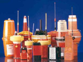
General descriptionMost beacons are brightly colored and waterproof. EPIRBs and ELTs are larger, and would fit in a cube about 30 cm on a side, and weigh 2 to 5 kg (4 to 11 lb). PLBs vary in size from cigarette-packet to paperback book and weigh 200 g to 1 kg (½ to 2½ lb). They can be purchased from marine suppliers, aircraft refitters, and (in Australia and the United States) hiking supply stores. The units have a useful life of 10 years, operate across a range of conditions (−40°C/°F to +40°C/+104°F), and transmit for 24 to 48 hours. As of 2003 the cost varies from US$139 to US$3000, with varying performance (see below). Classification nomenclatureThe three distress radiobeacon types are further classified as follows: Beacon modesThe most important aspect of a beacon in classification is the mode of transmission. There are two valid transmission modes: digital and analog. Digital mode – 406 MHz beacons406 MHz beacons transmit bursts of digital distress information to orbiting satellites, and may also contain a small integrated analog (121.5 MHz) homing beacon. Advanced 406 MHz beacons are capable of transmitting a highly-accurate GPS location within their distress message, thus, the process of distress relief is reduced from "search and rescue" to "get to and rescue". Getting to the location nonetheless may be very difficult. The distress message transmitted by a 406 beacon contains the information such as:
The digital distress message generated by the beacon varies according to the above factors and is encoded in 30 hexadecimal characters. The unique 15-character digital identity (the 15-hex ID) is hard-coded in the firmware of the beacon. SAR authorities refer to the distress messages and the identity transmitted by 406 beacons, variously, as hex codes. 406 MHz beacon facts
Hex codesExample hex codes look like the following:
SAR authorities and owners of beacons always refer to a beacon by its "15 Hex ID," which is printed or stamped on the outside of the beacon and is hard-coded into its firmware. When the beacon transmits a distress signal, this 15-hex ID is digitally encoded within the beacon variable (15, 22, and) 30-hexadecimal-character distress messages (also called the transmitted hex code.) The firmware 15-hex ID can only be reprogrammed by certified distress radiobeacon technicians.
Within its 30 hexadecimal character distress message, a 406 beacon will transmit a modified "15 Hex" code. These 15 hexadecimal characters will include both the encoded (physical/hard-coded) 15 hex ID of the beacon and, if GPS equipped, a rough (rounded) lat-long position. To determine a beacon's 15-hex ID from its transmitted 15-hex code, one can use the Cospas-Sarsat beacon decoder tool. When one enters the transmitted (i.e. GPS-location-included) 15-hex into the decoder, the unmodified 15-hex ID is printed at the bottom of the output of the Beacon Decoder page. This method can be used to confirm that a beacon is encoding the correct 15-hex ID (as printed on the side of the beacon) into its distress messages. Analog mode – all other beacons
FrequencyDistress beacons transmit distress signals on the following key frequencies; the frequency used distinguishes the capabilities of the beacon. A recognized beacon can operate on one of the three (currently) Cospas-Sarsat satellite-compatible frequencies. In the past, other frequencies were also used as a part of the search and rescue system. Cospas-Sarsat (satellite) compatible beacon frequencies
Cospas-Sarsat incompatible beacon frequencies
TypesThe type of a beacon is determined by the environment for which it was designed to be used:
Each type is sub-classified: EPIRB sub-classificationEPIRBS are sub-classified as follows: Recognized Categories:
Unrecognized Classes:
ELT sub-classificationELTs for aircraft may be classed as follows:
Within these classes, an ELT may be either a digital 406 MHz beacon, or an analog beacon (see above). PLB sub-classificationThere are two kinds of PLB:
All PLBs transmit in digital mode on 406 MHz. Additional information about PLBs can be obtained from the Ultimate PLB FAQ at Equipped to Survive. Activation methodsThere are two ways to activate a beacon:
Automatic EPIRBs are water activated, while automatic ELTs are G-force (impact) activated. Some EPIRBs also deploy; this means that they physically depart from their mounting bracket on the exterior of the vessel (usually by going into the water.) For a marine EPIRB to begin transmitting a signal (or "activate") it first needs to come out of its bracket (or "deploy"). Deployment can happen either manually—where someone has to physically take it out of its bracket—or automatically—where water pressure will cause a hydrostatic release unit to release the EPIRB from its bracket. If it does not come out of the bracket it will not activate. There is a magnet in the bracket which operates a reed safety switch in the EPIRB. This is to prevent accidental activation when the unit gets wet from rain or shipped seas. Once deployed, EPIRBs can be activated, depending on the circumstances, either manually (crewman flicks a switch) or automatically (as soon as water comes into contact with the unit's "sea-switch".) All modern EPIRBs provide both methods of activation and deployment and thus are labelled "Manual and Automatic Deployment and Activation." Advantages and disadvantages of the various beacons
See also Cospas-Sarsat - Advantages of 406 Beacons and Canada's National Search and Rescue Secretariat—Advantages of 406 Beacons Although modern systems are significantly superior to older ones, even the oldest systems provide an immense improvement in safety, compared to not having any beacon whatsoever. Phase-out of 121.5 & 243 beaconsBeginning 1 February 2009, only 406 MHz beacons are detected by the international Cospas-Sarsat SAR satellite system. This affects all maritime beacons (EPIRBs), all aviation beacons (ELTs) and all personal beacons (PLBs). In other words, Cospas-Sarsat ceased satellite processing of 121.5/243 MHz beacons. These beacons will only be able to be detected by ground-based receivers and aircraft. 121.5 and 243.0 MHz EPIRBs are banned on boats in the United States and in many other jurisdictions. More information about the switch to 406 is available on Cospas-Sarsat's 121.5/243 Phase-Out page. Despite the switch to 406 MHz, pilots and ground stations are encouraged to continue to monitor for transmissions on the emergency frequencies, as many 406 beacons are also equipped with 121.5 "homers." Furthermore, the 121.5 MHz frequency continues to be used as a voice distress frequency (especially in aviation). SAR response to various beaconsEmergency beacons operating on 406 MHz transmit a unique 15, 22, or 30 character serial number called a Hex Code. When the beacon is purchased the Hex Code should be registered with the relevant national (or international) authority. Registration provides Search and Rescue agencies with crucial information such as:
Registration information allows SAR agencies to start a rescue more quickly. For example, if a shipboard telephone number listed in the registration is unreachable, it could be assumed that a real distress event is occurring. Conversely, the information provides a quick and easy way for the SAR agencies to check and eliminate false alarms (potentially sparing the owner of the beacon significant false alert fines.) An unregistered 406 beacon still carries some information, such as the manufacturer and serial number of the beacon, and in some cases, an MMSI or aircraft tail number / ICAO 24-bit address. Despite the clear benefits of registration, an unregistered 406 beacon is very substantially better than a 121.5/243.0 beacon; this is because the Hex Code received from a 406 beacon confirms the authenticity of the signal as a real SAR alert. Beacons operating on 121.5 and/or 243.0 MHz simply transmit an anonymous siren tone, and thus carry no information to SAR agencies. Such beacons implicitly rely on the doppler location detection system, or on terrestrial or aeronautical monitoring of the frequency. In the UK, the Distress and Diversion Cell of the Royal Air Force provides continuous monitoring of 121.5 and 243.0 MHz, with autotriangulation from a network of terrestrial receivers on both frequencies. SAR authorities have no way of knowing whether a 121.5/243.0 MHz signal is actually a SAR signal until they physically deploy to the location and home in on the source (and sound) of the transmission. Since SAR resources are scarce (and expensive), most countries do not deploy the most useful SAR homing assets (aircraft) until ambiguity has been resolved (see doppler)... Responsible agenciesIn the U.S., offshore beacons are investigated and victims rescued by the Coast Guard. On-shore beacons are investigated by local search and rescue services in Alaska. The Air Force Rescue Coordination Center is charged with land-based emergency signals, usually dispatching volunteer members from The United States Air Force Auxiliary Civil Air Patrol. In the U.S. there are no published notification systems for other locations. Statutory requirementsIn the U.S. (as in most jurisdictions) no special license is required to operate an EPIRB. The following paragraphs define other requirements relating to EPIRBs, ELTs, and PLBs. RegistrationAll distress alerting beacons operating on 406 MHz should be registered; all vessels and aircraft operating under SOLAS and ICAO regulations must register their beacons. Some national administrations (including the United States, Canada, Australia, and the UK) also require registration of 406 MHz beacons.
The Cospas-Sarsat Handbook of Beacon Regulations provides the status of 406 MHz beacon regulations in specific countries and extracts of some international regulations pertaining to 406 MHz beacons. The following list shows the agencies accepting 406 beacon registrations by country:
Environment-specific requirementsAviation (ELTs)Most general aviation aircraft in the U.S. are required to carry an ELT, depending upon the type or location of operation, while scheduled flights by scheduled air carriers are not. However, in commercial aircraft, a cockpit voice recorder or flight data recorder must contain an Underwater locator beacon. As per 14 CFR 91.207.a.1, ELTs built according to TSO-C91 (of the type described below as "Traditional ELT, unregistered") have not been permitted for new installations since June 21, 1995; the replacing standard was TSO-C91a. Furthermore, TSO-C91/91a ELTs are scheduled to phased out February 1, 2009 to be replaced by the 406 MHzELT, a far superior unit. Though monitoring of 121.5 and 243 MHz (Class B) distress signals by satellite is scheduled to cease in 2009, there is currently no upgrade of older ELT units mandated by the FAA for aircraft in the United States. Marine (EPIRBs)EPIRBs are a component of the Global Maritime Distress Safety System (GMDSS). Most commercial off-shore working vessels with passengers are required to carry a self-deploying EPIRB, while most in-shore and fresh-water craft are not. As part of the United States efforts to prepare beacon users for the end of 121.5 MHz frequency processing by satellites, the FCC has prohibited the use of 121.5 MHz EPIRBs as of January 1, 2007 (47 CFR 80.1051). See the United States Coast Guard (USCG) brief on the 121.5/243 Phase-out. The most current and comprehensive information about EPIRBs is provided by the Equipped To Survive Foundation. Personal locator beacons (PLBs)Personal locator beacons operating on 406 MHz must be registered. PLBs should not be used in cases where normal emergency response exists. Detailed type descriptionsCurrent typesEPIRBs (marine)Current marine EPIRBs are generally divided into three classes; Category I, Category II, and Class B (or Category B).
ELTs (aircraft)ELTs used in aircraft are of the following types:
Types Being Phased Out:
PLBsAll PLBs must have a Hex Code on the body. Persons must register this Hex Code with their national SAR agency. See below for types of PLBs no longer used. Obsolete typesObsolete EPIRBsThere are also several older types of EPIRB devices which are no longer recommended for use.
Furthermore, the U.S. Coast Guard recommend that no EPIRB of any type manufactured before 1989 be used. Obsolete ELTs
Obsolete PLBs
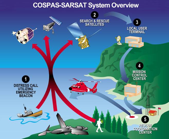
How they workAll the systems work something like this: A beacon is activated by a crash, a sinking, or manually by survivors. The beacon's transmission is picked up by one or more satellites. The satellite transmits the beacon's signal to its ground control station. The satellite's ground station processes the signals and forwards the data, including approximate location, to a national authority. The national authority forwards the data to a rescuing authority. The rescuing authority uses its own receiving equipment to locate the beacon and makes the rescue or recovery. Once the satellite data is in, it takes less than a minute to forward the data to any signatory nation.
There are several systems in use, with beacons of varying expense, different types of satellites and varying performance. Note that even the oldest systems provide an immense improvement in safety, compared to not having a beacon. GPS-based, registeredThe most modern 406 MHz beacons with GPS (US$ $500 in 2008) locate a beacon with a precision of 100 meters, anywhere in the world, and send a serial number so the government authority can look up phone numbers to notify next-of-kin in four minutes, with rescue commencing shortly afterward. The GPS system permits stationary, wide-view geosynchronous communications satellites to enhance the doppler position received by low Earth orbit satellites. EPIRB beacons with built-in GPS are usually called GPIRBs, for GPS Position-Indicating Radio Beacon or Global Position-Indicating Radio Beacon. High-precision registeredAn intermediate technology 406 MHz beacon (US$ 500-900) has worldwide coverage, locates within 2 km (12.5 km² search area), notifies kin and rescuers in 2 hours maximum (46 min average), and has a serial number to look up phone numbers, etc. This can take up to two hours because it has to use moving weather satellites to locate the beacon. To help locate the beacon, the beacon's frequency is controlled to 2 parts per billion, and its power is a hefty five watts. Both of the above types of beacons usually include an auxiliary 25 milliwatt beacon at 121.5 MHz to guide rescue aircraft. Traditional ELT, unregisteredThe oldest, cheapest (US$ 139) beacons send an anonymous warble at 121.5 MHz. They can be detected by satellite over only 60% of the earth, require up to 6 hours for notification, locate within 20 km (search area of 1200 km²) and are anonymous. Coverage is partial because the satellite has to be in view of both the beacon and a ground station at the same time—the satellites do not store and forward the beacon's position. Coverage in polar and south-hemisphere areas is poor. The frequency is the standard aviation emergency frequency, and there is interference from other electronic and electrical systems, so false alarms are common. To reduce false alarms, a beacon is confirmed by a second satellite pass, which can easily slow confirmation of a 'case' of distress to up to about 4 hours (although in rare circumstances the satellites could be position such that immediate detection becomes possible.) Also, the beacons can't be located as well because their frequency is only accurate to 50 parts per million, and they send only 75-100 milliwatts of power. These ELTs will not be monitored by Cospas-Sarsat after February 1, 2009. Location by Doppler (without GPS)When the beacon has no GPS receiver, the system locates the beacon from its Doppler shift as received by the quickly-moving satellites. Using the same techniques as radar, basically, the frequency received varies depending on the speed of the beacon relative to the satellite. The amount of shift is proportional to the range and bearing to the satellite. The instant the beacon's Doppler shift changes from high to low indicates the time when the bearing from the beacon to the satellite's ground track is 90 degrees. The side of the satellite track is determined because the rate of change of the Doppler shift is faster when the Earth is turning towards the satellite track. One key to an effective Doppler position triangulation is excellent frequency stability. If the signal is not monotone (stable), then the results of the triangulation will vary. This is why 406 MHz beacons can be triangulated to within 5km and the b-side (unlikely mirror position) can be ruled out with 98.5% accuracy, whereas the old technology of analog beacons is only accurate to within a 20 km radius per mirror image, each of which is roughly equally likely to be the correct position. In order to handle multiple simultaneous beacons, modern 406 MHz beacons transmit in bursts, and remain silent for a few seconds. This also conserves transmitter power. Russia developed the original system, and its success drove the desire to develop the improved 406 MHz system. The original system is a brilliant adaptation to the low quality beacons, originally designed to aid air searches. It uses just a simple, lightweight transponder on the satellite, with no digital recorders or other complexities. Ground stations listen to each satellite as long as it is above the horizon. Doppler shift is used to locate the beacon(s). Multiple beacons are separated when a computer program performs a Fourier transform on the signal. Also, two satellite passes per beacon are used. This eliminates false alarms by using two measurements to verify the beacon's location from two different bearings. This prevents false alarms from VHF channels that affect a single satellite. Regrettably, the second satellite pass almost doubles the average time before notification of the rescuing authority. However, the notification time is much less than a day. Operational testingAccording to the FAA, ground testing of type A, B and S ELTs is to be done within the first 5 minutes of each hour. Testing is restricted to 3 audio sweeps. [2] Type I and II devices (those transmitting at 406 MHz) have a self test function and must not be activated except in an actual emergency. The Coast Guard web page for EPIRBs states: "You may be fined for false activation of an unregistered EPIRB. The U.S. Coast Guard routinely refers cases involving the non-distress activation of an EPIRB (e.g., as a hoax, through gross negligence, carelessness or improper storage and handling) to the Federal Communications Commission. The FCC will prosecute cases based upon evidence provided by the Coast Guard, and will issue warning letters or notices of apparent liability for fines up to $10,000." [3] Satellites usedReceivers are auxiliary systems mounted on several types of satellites. This substantially reduces the program's cost. The weather satellites that carry the SARSAT receivers are in "ball of yarn" orbits, inclined at 99 degrees. The longest period that all satellites can be out of line-of-sight of a beacon is about two hours. The first satellite constellation was launched in the early 1970s by the Soviet Union, Canada, France and the USA. Some geosynchronous satellites have beacon receivers. Since end of 2003 there are four such geostationary satellites (GEOSAR) that cover more than 80% of the surface of the earth. As with all geosynchronous satellites, they are located above the equator. The GEOSAR satellites do not cover the polar caps. Since they see the Earth as a whole, they see the beacon immediately, but have no motion, and thus no doppler frequency shift to locate it. However, if the beacon transmits GPS data, the geosynchronous satellites give nearly instantaneous response. HistoryThe original impetus for the program in the U.S. was the loss of Congressmen Hale Boggs (D-LA) and Nick Begich (D-AK) in the Alaskan wilderness on October 16, 1972. A massive search effort failed to locate them. The result was a U.S. law mandating that all aircraft carry an emergency locator transmitter. Technical and organizational improvements followed. Cospas-Sarsat is an international organization that has been a model of international cooperation, even during the Cold War. SARSAT means Search And Rescue SATellite. COSPAS is a Russian acronym with the same meaning. A consortium of Russia, the U.S., Canada and France formed the organization in 1982. Since then 29 others have joined. Cospas-Sarsat defines standards for beacons, auxiliary equipment to be mounted on conforming weather and communication satellites, ground stations, and communications methods. The satellites communicate the beacon data to their ground stations, which forward it to main control centers of each nation that can initiate a rescue effort. The U.S. Coast Guard once promoted an emergency beacon on maritime VHF emergency channels. It now promotes the superior Cospas-Sarsat system, and no longer services emergency beacons on maritime VHF frequencies. Current eventsIn a Safety Recommendation released September 2007, the US National Transportation Safety Board once again recommended that the FAA require all aircraft have 406 MHz ELTs. They first recommended this back in 2000 and after vigorous opposition by AOPA, the FAA declined to do so. This recommendation is apparently a reaction to the looming cessation of 121.5 MHz satellite processing. Citing two recent accidents, one with a 121.5 MHz ELT and one with a 406 MHz ELT, the NTSB concludes that switching all ELTs to 406 MHz by 1 February 2009 is a necessary goal to work towards. Alternate TechnologiesThere are also other personal devices in the marketplace which do not meet the standard for 406 MHz devices. SPOTSPOT does not use the 406 MHz signal nor the system of satellites. Instead, it depends on the GlobalStar satellite system. It has richer features (for instance, can send many non-emergency signals) -- but it does not work in as many places as 406 MHz PLBs - for instance under dense forest canopy or steep canyons.When a user presses the "911" button on a SPOT device an emergency message containing the unit's identification and GPS location is transmitted to the GEOS International Emergency Response Center who then notifies the appropriate emergency agency for the region after first calling the user to ensure the transmission is not accidental. SPOT additionally has the ability to provide non-emergency web based tracking information. This allows family or friends at home to track the holder's progress. The tracking operates by sending a tracking signal to the GlobalStar network every 10 minutes. This feature can additionally be useful to provide location of an individual even if the individual is unable to activate the emergency '911' button. Typical costs are $169 plus a $99/year service fee for basic services or $150/yr for basic services and tracking services, as compared to around $500 for a 406-MHz PLB with no service fee. TracMeTracMesimply beacons an automated message on a short-range VHF frequency. It does not notify authorities that you are missing. TracMe's website recommends you arrange for rescue by notifying a friend about your plans, and ask them to call authorities and inform them of your general whereabouts and that you have a TracMe if you are late returning.Then, the search-and-rescue team will need to radio-triangulate on the signal. TracMe has had a dispute with the FCC whether the device can be called a "Personal Locator Beacon". It costs $149 and allows a single use. The company promises a free replacement if it's used for a genuine emergency. APRSAutomatic Position Reporting System is used by amateur radio operators to track positions and send short messages. Most APRS packets contain a GPS latitude and longitude, so they can be used for both normal and emergency tracking. They also are routed to the internet, where they are archived for some period of time, and viewable by others There are several Emergency packet types that can indicate distress. Since it is part of the amateur radio service, it costs nothing to transmit on and uses the extensive network, however, one must be a licensed amateur radio operator. There is also no guarantee that an APRS distress packet report would be seen or handled by emergency responders. It would have to be seen by an amateur radio operator and forwarded on. See also
External links
Text from Wikipedia is available under the Creative Commons Attribution/Share-Alike License; additional terms may apply.
Published in July 2009. Click here to read more articles related to aviation and space!
|

 |
|
Copyright 2004-2026 © by Airports-Worldwide.com, Vyshenskoho st. 36, Lviv 79010, Ukraine Legal Disclaimer |