Thessaloniki International Airport "Macedonia" |
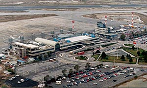 Makedonia
Airport is about 15 km SE of the city centre of Thessaloniki.
Its IATA airport code is SKG, and its ICAO airport code is LGTS. It is
the second most used airport in Greece. It also has international flights
to European and some Middle Eastern cities. Makedonia
Airport is about 15 km SE of the city centre of Thessaloniki.
Its IATA airport code is SKG, and its ICAO airport code is LGTS. It is
the second most used airport in Greece. It also has international flights
to European and some Middle Eastern cities.
The airport was opened in 1930.
Distance and Direction from city: 7 NM BRG 170° from city center.
Refernce point: 403111? 225815?
Elevation: 22FT
Runway: Designation 104°/284° Dimensions 2440x50
166°/346° 2410x60
Telephone Directory
Airport Call Center: +32310473212
Airport Manager: +32310473700 Fax:+30231985107
Airport Operation Section: +302310985138
Air Traffic Services Section: +302310985116
Telecommunications Section: +302310475555 Fax:+302310985117
Electronics Section: +302310985122
Maintenance Section: +302310985133
Administration - Finance Section: +302310985108
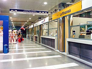 Airlines Airlines
Olympic Airways :+302310-408411, 473955, 985259 FAX : 2310-408422
CRONUS AIRLINES : +302310-476054, 476055, 985217 FAX : 2310-476053
AEGEAN AIRLINES : +302310-476477, 476473, 476472, 985349
SIMULATOR CENTER: +302310- 475822-475829
AVIATOR: +302945-975063
KAL AVIATION : +302944-268660
Air traffic statistics 2000
Flights: 49.007
Passengers: 3.548.027
Post Address:
THESSALONIKI INTERNATIONAL AIRPORT
"MACEDONIA"
Wall box : 226 05
551 03 KALAMARIA
THESSALONIKI
Tel.: +30 231 473700 / 2310 473312
Fax: +30 2310 475555
TELEX : 0418889 LGTS GR
E-mail : kacmtl at otenet gr
WEB: http://www.hcaa-eleng.gr/thes.htm
Images and information placed above are from
http://www.hcaa-eleng.gr/thes.htm
We thank them for the data!
| General Info
|
| Country |
Greece
|
| ICAO ID |
LGTS
|
| Time |
UTC+2(+3DT)
|
| Latitude |
40.519725
40° 31' 11.01" N
|
| Longitude |
22.970950
022° 58' 15.42" E
|
| Elevation |
22 feet
7 meters
|
| Type |
Civil
|
| Magnetic Variation |
003° E (01/05)
|
| Beacon |
Yes
|
| Near City |
Thessaloniki
|
| Operating Hours |
24 HOUR OPERATIONS
|
| International Clearance Status |
Airport of Entry
|
| Daylight Savings Time |
Last Sunday in March to last Sunday in October
|
| Communications
|
| TWR |
118.1
122.1
257.8
|
| GND |
121.7
|
| CLNC DEL |
118.05
|
ATIS
Opr 0500-2000Z++ 1 Apr-31 Oct, 0600-2000Z++ 1 Nov-31 Mar.
|
127.55
|
| APP |
120.8
122.1
362.3
|
| RDO |
5637
2989
(5637 Opr 0400-1700Z++) (2989 Opr 1700-0400Z++)
|
| Communications Remarks |
|
| GND |
Call on GND for start up and taxi clnc.
|
| Runways
|
| ID |
Dimensions |
Surface |
PCN |
ILS
|
| 10/28 |
8005 x 164 feet
2440 x 50 meters |
ASPHALT |
040FBXU |
YES
|
| 16/34 |
7907 x 197 feet
2410 x 60 meters |
ASPHALT |
040FBXU |
YES
|
| Navaids
|
| Type |
ID |
Name |
Channel |
Freq |
Distance From Field |
Bearing From Navaid
|
| TACAN |
MKA |
MIKRA |
100X |
- |
At Field |
-
|
| VOR-DME |
TSL |
THESSALONIKI |
058X |
112.1 |
3.9 NM |
345.3
|
| NDB |
THS |
THESSALONIKI |
- |
345 |
4.6 NM |
166.7
|
| Supplies/Equipment
|
| Fuel |
JP-4, Wide cut turbine fuel MIL Spec T-5624
Jet A1, without icing nhibitor.
115/145 octane gasoline, leaded, MIL-L-5572F (PURPLE)
80/87 octane gasoline, leaded, MIL-L-5572F (RED)
100/130 MIL Spec, low lead, aviation gasoline (BLUE)
|
| Remarks
|
| CAUTION |
Bird haz. Acft ldg Rwy 10-28 make 180 turn to rgt on conc rwy ends.
|
| FUEL |
A1 (EKO Elda Abee, fone C30-31-04-73377) (NC-100LL)
|
| LGT |
ABn, green coded C.
|
| RSTD |
Tkof dist reduced 196' both rwy to limit jet blast damage to A-G.
|
Runway 10/28
8005 x 164 feet
2440 x 50 meters
| Runway 10
|
| Surface |
ASPHALT
|
| True Heading |
104.0
|
| Latitude |
40.521961
40° 31' 19.06" N
|
| Longitude |
22.959075
022° 57' 32.67" E
|
| Elevation |
7.0 feet
2 meters
|
| Slope |
0.1°
|
| Landing Distance |
8005 feet
2440 meters
|
| Takeoff Distance |
8005 feet
2440 meters
|
| Lighting System |
HIRL
REIL
A2
PAPI |
| Runway 28
|
| Surface |
ASPHALT
|
| True Heading |
284.0
|
| Latitude |
40.516678
40° 31' 00.04" N
|
| Longitude |
22.987028
022° 59' 13.30" E
|
| Elevation |
19.0 feet
6 meters
|
| Slope |
-0.1°
|
| Landing Distance |
8005 feet
2440 meters
|
| Takeoff Distance |
8005 feet
2440 meters
|
| Lighting System |
SF
HIRL
REIL
A1
PAPI |
Runway 16/34
7907 x 197 feet
2410 x 60 meters
| Runway 16
|
| Surface |
ASPHALT
|
| True Heading |
166.0
|
| Latitude |
40.530278
40° 31' 49.00" N
|
| Longitude |
22.967611
022° 58' 03.40" E
|
| Elevation |
12.0 feet
4 meters
|
| Slope |
0.1°
|
| Landing Distance |
7907 feet
2410 meters
|
| Takeoff Distance |
8107 feet
2471 meters
|
| Overrun Length |
200 feet
61 meters
|
| Overrun Surface |
ASPHALT
|
| Lighting System |
HIRL
REIL
A
PAPI |
| Runway 34
|
| Surface |
ASPHALT
|
| True Heading |
346.0
|
| Latitude |
40.509169
40° 30' 33.01" N
|
| Longitude |
22.974353
022° 58' 27.67" E
|
| Elevation |
22.0 feet
7 meters
|
| Slope |
-0.1°
|
| Landing Distance |
7907 feet
2410 meters
|
| Takeoff Distance |
8107 feet
2471 meters
|
| Overrun Length |
200 feet
61 meters
|
| Overrun Surface |
ASPHALT
|
| Lighting System |
HIRL
REIL
A2
PAPI |
Navaids
| MIKRA
|
| Type |
ID |
Channel |
Freq |
Country |
State
|
| TACAN |
MKA |
100X |
- |
Greece |
-
|
| Latitude |
Longitude |
Airport
|
40.517500
40° 31' 03.00" N |
22.976667
022° 58' 36.00" E |
LGTS |
Navaids
| THESSALONIKI
|
| Type |
ID |
Channel |
Freq |
Country |
State
|
| VOR-DME |
TSL |
058X |
112.1 |
Greece |
-
|
| Latitude |
Longitude |
Airport
|
40.456808
40° 27' 24.51" N |
22.991058
022° 59' 27.81" E |
LGTS |
Navaids
| THESSALONIKI
|
| Type |
ID |
Channel |
Freq |
Country |
State
|
| NDB |
THS |
- |
345 |
Greece |
-
|
| Latitude |
Longitude |
Airport
|
40.593600
40° 35' 36.96" N |
22.948086
022° 56' 53.11" E |
LGTS |
The content above was published at Airports-Worldwide.com in 2005.
We don't guarantee the information is fresh and accurate. The data may be wrong or outdated.
For more up-to-date information please refer to other sources.
|


