Rhodos International Airport, Diagoras |
Rhodos International Airport, Diagoras
 The
airport was opened in 1977. The
airport was opened in 1977.
Distance and Direction from city: 8 NM BRG 253° from city harbour..
Refernce point: 362420N 280513E
Elevation: 17FT
Runway: Designation 070°/250° Dimensions 3260x45
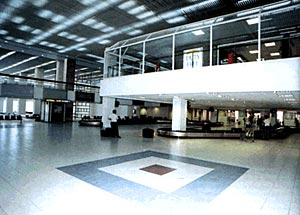
Diagoras Airport is located on the island of Rhodes.
The airport is located 14km south west of the capital, the city of Rhodes,
near the village of Paradisi. It is the third busiest airport of Greece
in total passenger volume. The airport entered operation in 1977.
The airport covers a total area of 31,000 sq.m. and with the undergoing
expansion its going to be doubled. The new terminal is supposed to be
operative by the end of 2005 and will improve the services offered to
charter airlines.
Diagoras Airport operates all day all year and many
facilities are available;car hire,banks,duty-free,cafes and parking space
outside the terminal.
 In
the inter Diagoras connects Rhodes with
Athens on a daily basis(up to 8 flights/day),with Salonica, Heraklio and
Cyprus(3 to 5 times/week) and with the nearby islands of Kastelorizo,
Karpathos In
the inter Diagoras connects Rhodes with
Athens on a daily basis(up to 8 flights/day),with Salonica, Heraklio and
Cyprus(3 to 5 times/week) and with the nearby islands of Kastelorizo,
Karpathos
Kasos, Kos, , Mytilini, Limnos, Chios and Samos. During the summer, except
the domestic destinations the airport becomes a charter hub and the island
is connected with most of the major European cities and some Arabians.
POSTAL ADDRESS: Diagoras Airport
85106 RODOS
GREECE
TELEPHONE: +302241088900
TELEX: 292463 LGRP GR
FAX: +302241083210
WEBSITE:
e-mail: kardtl at otenet gr
IATA CODE: RHO
Telephone Directory
Airport Call Center: +302241088900
Airport Manager: +302241088901
Airport Operation Section: +302241088913
Air Traffic Services Section: +302241088814
Telecommunications Section: +302241088910 Fax:+302241083210
Electronics Section: +302241088706
Maintenance Section: +302241088907
Administration - Finance Section:+302241088907
Airlines
Oloympic Airways : +3022410 88401, 88403
CRONUS AIRLINES : +3022410 82225
AEGEAN AIRLINES : +3022410 98345
KAL AVIATION (cargo) : +3022410 82128 - 0944 987188
Air traffic statistics 2000
Flights:29.642
Passengers:3.407.050
WEB: http://www.hcaa-eleng.gr/rhod.htm
Images and information placed above are from
http://www.hcaa-eleng.gr/rhod.htm
http://encyclopedia.thefreedictionary.com/Diagoras+Airport
We thank them for the data!
| General Info
|
| Country |
Greece
|
| ICAO ID |
LGRP
|
| Time |
UTC+2(+3DT)
|
| Latitude |
36.405419
36° 24' 19.51" N
|
| Longitude |
28.086192
028° 05' 10.29" E
|
| Elevation |
19 feet
6 meters
|
| Type |
Civil
|
| Magnetic Variation |
003° E (01/05)
|
| Beacon |
Yes
|
| Near City |
Rodos
|
| Operating Hours |
24 HOUR OPERATIONS
|
| International Clearance Status |
Airport of Entry
|
| Daylight Savings Time |
Last Sunday in March to last Sunday in October
|
| Communications
|
| TWR |
118.2
122.1
257.8
381.0
|
| GND |
121.7
|
ATIS
Opr 0600-2000Z++ 1 Apr-31 Oct.
|
126.35
|
| APP |
118.25
120.6
122.1
381.0
|
| RDO |
5637
2989
(5637 Opr 0400-1700Z++) (2989 Opr 1700-0400Z++)
|
| Communications Remarks |
|
| TWR |
Afct on VFR apch fr S-SE blw FL100 ctc APP due to ltd propagation on 118.2.
|
| Runways
|
| ID |
Dimensions |
Surface |
PCN |
ILS
|
| 07/25 |
10846 x 148 feet
3306 x 45 meters |
ASPHALT |
073FBXU |
YES
|
| Navaids
|
| Type |
ID |
Name |
Channel |
Freq |
Distance From Field |
Bearing From Navaid
|
| TACAN |
ROD |
RODOS |
121X |
- |
3.9 NM |
002.7
|
| VOR-DME |
RDS |
RODOS |
105X |
115.8 |
3.9 NM |
001.8
|
| NDB |
ROS |
RODOS |
- |
339 |
1.7 NM |
240.5
|
| Supplies/Equipment
|
| Fuel |
Jet A1, without icing nhibitor.
100/130 MIL Spec, low lead, aviation gasoline (BLUE)
|
| Remarks
|
| CAUTION |
Mod to severe turb and windshear may be experienced. Bird haz.
|
| FUEL |
A1(EKO Elda Abee, fone C30-24-10-82834), (NC-100LL).
|
| LGT |
PAPI left side Rwy 07-25 only. CL Rwy 07 O/S UFN. TDZL Rwy 25 O/S UF.
|
| MISC |
While on apch and/or dep, pilots are urged to provide windshear rpt to TWR or APP ASAP.
|
| RSTD |
VMC ovft city of Rodos proh.
|
Runway 07/25
10846 x 148 feet
3306 x 45 meters
| Runway 07
|
| Surface |
ASPHALT
|
| True Heading |
070.0
|
| Latitude |
36.400339
36° 24' 01.22" N
|
| Longitude |
28.068869
028° 04' 07.93" E
|
| Elevation |
16.0 feet
5 meters
|
| Slope |
0.0°
|
| Landing Distance |
10846 feet
3306 meters
|
| Takeoff Distance |
10846 feet
3306 meters
|
| Lighting System |
HIRL
A2
PAPI |
| Runway 25
|
| Surface |
ASPHALT
|
| True Heading |
250.0
|
| Latitude |
36.410500
36° 24' 37.80" N
|
| Longitude |
28.103517
028° 06' 12.66" E
|
| Elevation |
17.0 feet
5 meters
|
| Slope |
0.0°
|
| Landing Distance |
10846 feet
3306 meters
|
| Takeoff Distance |
10846 feet
3306 meters
|
| Lighting System |
HIRL
A
PAPI |
Navaids
| RODOS
|
| Type |
ID |
Channel |
Freq |
Country |
State
|
| TACAN |
ROD |
121X |
- |
Greece |
-
|
| Latitude |
Longitude |
Airport
|
36.341111
36° 20' 28.00" N |
28.082500
028° 04' 57.00" E |
LGRP |
Navaids
| RODOS
|
| Type |
ID |
Channel |
Freq |
Country |
State
|
| VOR-DME |
RDS |
105X |
115.8 |
Greece |
-
|
| Latitude |
Longitude |
Airport
|
36.339722
36° 20' 23.00" N |
28.082222
028° 04' 56.00" E |
LGRP |
Navaids
| RODOS
|
| Type |
ID |
Channel |
Freq |
Country |
State
|
| NDB |
ROS |
- |
339 |
Greece |
-
|
| Latitude |
Longitude |
Airport
|
36.418333
36° 25' 06.00" N |
28.118056
028° 07' 05.00" E |
LGRP |
The content above was published at Airports-Worldwide.com in 2005.
We don't guarantee the information is fresh and accurate. The data may be wrong or outdated.
For more up-to-date information please refer to other sources.
|


