 |
 |
|
||||
|
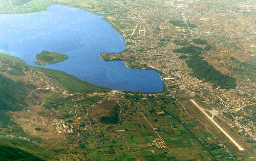
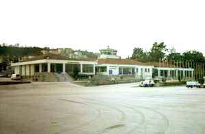
Ioannina Airport is located 5 Km northwest of the city. It is a rather small airport that serves normally domestic or general aviation flights. History The airport was founded at 1928-29. From 1932 up to 1940 a semi-national company was running it. During the World War II the airport was occupied by the Italians. In 1946-47 the runway was paved with PSPs. In 1947 an Air Force squad was settled in common with a meteorogical station. In 1972 PSPs were replaced by asphalt and the runway length became 1200 m. In 1974-76 an expropriation took place by the Hellenic Civil Aiation Aythority, bringing the total area at 1400000 m2. At the same time the new runway was constructed with an orientation of 142�-322�, length 2400 m. and width 45 m., as well as the new 20000 m2 apron. Today the airport building covers an 1300 m2 area. About Ioannina The city of Ioannina is the administrative, commercial and cultural center of Epirus. It is lying at the shores of lake "Pamvotis" at an altitude of 450 m. and is known as "the city of legends and traditions". It is considered a special destination in common with the surrounding areas, full of unique natural beauties. It is worth visiting the town castle with its narrow streets and museums, the picturesque small island in the lake, the remarkable cave of Perama as well as the renowned Wax Museum of Paul Vrellis. All over the district there are areas of sublime beauty that offer a
unique opportunity to visit and explore them. Distance and Direction from city: 2,5 NM BRG 325° from city. Refernce point: 394154N 204921E POSTAL ADDRESS: Ioannina Airport TELEPHONE: +302651083600 Air traffic statistics 2000 Images and information placed above are from
Runway 14/327874 x 148 feet
|
||||||||||||||||||||||||||||||||||||||||||||||||||||||||||||||||||||||||||||||||||||||||||||||||||||||||||||||||||||||||||||||||||||||||||||||||||||||||||||||||||||||||||||||||||||||||||||||||||||||||||||||
| Runway 14 | |
|---|---|
| Surface | ASPHALT |
| True Heading | 142.0 |
| Latitude | 39.705003 39° 42' 18.01" N |
| Longitude | 20.813889 020° 48' 50.00" E |
| Elevation | 1549.0 feet 472 meters |
| Slope | 0.1° |
| Landing Distance | 7874 feet 2400 meters |
| Takeoff Distance | 7874 feet 2400 meters |
| Lighting System | PAPI |
| Runway 32 | |
|---|---|
| Surface | ASPHALT |
| True Heading | 322.0 |
| Latitude | 39.688058 39° 41' 17.01" N |
| Longitude | 20.831111 020° 49' 52.00" E |
| Elevation | 1557.0 feet 475 meters |
| Slope | -0.1° |
| Landing Distance | 7480 feet 2280 meters |
| Takeoff Distance | 7874 feet 2400 meters |
| Displaced Threshold Length | 394 feet 120 meters |
| Lighting System | PAPI |
| YIANNENA | |||||
|---|---|---|---|---|---|
| Type | ID | Channel | Freq | Country | State |
| VOR-DME | YNN | 023X | 108.6 | Greece | - |
| Latitude | Longitude | Airport |
| 39.700033 39° 42' 00.12" N |
20.821317 020° 49' 16.74" E |
LGIO |
| YIANNENA | |||||
|---|---|---|---|---|---|
| Type | ID | Channel | Freq | Country | State |
| NDB | IOA | - | 340 | Greece | - |
| Latitude | Longitude | Airport |
| 39.698889 39° 41' 56.00" N |
20.816111 020° 48' 58.00" E |
LGIO |
The content above was published at Airports-Worldwide.com in 2005.
We don't guarantee the information is fresh and accurate. The data may be wrong or outdated.
For more up-to-date information please refer to other sources.

 |
|
Copyright 2004-2026 © by Airports-Worldwide.com, Vyshenskoho st. 36, Lviv 79010, Ukraine Legal Disclaimer |
 Ioannina
Airport
Ioannina
Airport