 |
 |
|
||||
|
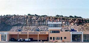
Distance and Direction from city: 4,86 NM BRG 032 from city Ag.Kirikos. Refernce point: 374101N 262052E POSTAL ADDRESS: Ikaria Airport Telephone Directory Car Rental Air traffic statistics 2000 WEB: http://www.hcaa-eleng.gr/ikaria.htm Images and information placed above are from
Runway 15/334297 x 98 feet
|
||||||||||||||||||||||||||||||||||||||||||||||||||||||||||||||||||||||||||||||||||||||||||||||||||||||||||||||||||||||||||||||||||||||||||||||||||||||||||||||||||||||||||||
| Runway 15 | |
|---|---|
| Surface | ASPHALT |
| True Heading | 152.0 |
| Latitude | 37.685889 37° 41' 09.20" N |
| Longitude | 26.344139 026° 20' 38.90" E |
| Elevation | 58.0 feet 18 meters |
| Slope | 0.5° |
| Landing Distance | 4297 feet 1310 meters |
| Takeoff Distance | 4297 feet 1310 meters |
| Lighting System | MIRL
PAPI |
| Runway 33 | |
|---|---|
| Surface | ASPHALT |
| True Heading | 332.0 |
| Latitude | 37.675447 37° 40' 31.61" N |
| Longitude | 26.351028 026° 21' 03.70" E |
| Elevation | 80.0 feet 24 meters |
| Slope | -0.5° |
| Landing Distance | 4019 feet 1225 meters |
| Takeoff Distance | 4297 feet 1310 meters |
| Displaced Threshold Length | 278 feet 85 meters |
| Lighting System | MIRL
PAPI |
| IKARIA | |||||
|---|---|---|---|---|---|
| Type | ID | Channel | Freq | Country | State |
| NDB | IKA | - | 322 | Greece | - |
| Latitude | Longitude | Airport |
| 37.682900 37° 40' 58.44" N |
26.345553 026° 20' 43.99" E |
LGIK |
The content above was published at Airports-Worldwide.com in 2005.
We don't guarantee the information is fresh and accurate. The data may be wrong or outdated.
For more up-to-date information please refer to other sources.

 |
|
Copyright 2004-2026 © by Airports-Worldwide.com, Vyshenskoho st. 36, Lviv 79010, Ukraine Legal Disclaimer |
 Ikaria
Airport
Ikaria
Airport