|
 ICAO
Code EDUZ ICAO
Code EDUZ
Name ZERBST
Land Deutschland
Bundesland Sachsen-Anhalt
Letzte Änderung 6. März 2002
Kategorie Sonderlandeplatz / Special Airfield
Betreiber / Operator Luftsportverein Zerbst e.V.
Lage / Location 1,8 NM NE Zerbst
LFZ / ACFT Bis / up to 5700 kg, 14000 kg PPR
Helicopter Ja / Yes
Motorsegler / GLDP Ja / Yes
Segelflugzeuge / GLD Ja / Yes
Ballone Ja / Yes
UL Ja / Yes
Luftschiffe/airships, Modellflugzeuge/Model flying
Summer PPR
Winter PPR
O/T PPR
Luftaufsicht / OPS 0171 4971519, 0163 4888400
PPR 0171 4971519, 0163 4888400
AIS EDDB +49 (0)30 / 60918250
MET (0190) 077222
Gafor 16
Fuel Nein / No
Oil Nein / No
Hangar Ja / Yes
Höhe / Elevation 266 ft / 88 m
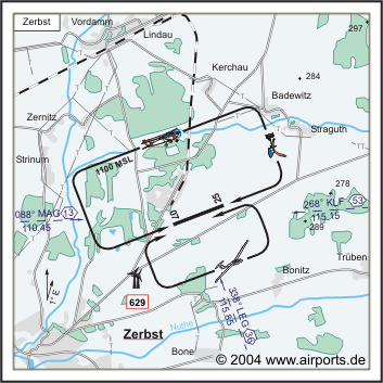
FIS Berlin Information 125.800
Rufzeichen / Call sign Zerbst Info
Frequenz Tower 123.050 GE
NAV Aids 338°/36 NM from LEG 115.85 88°/13 NM from MAG 110.45
Koordinaten 51 59, 85 N / 12 08, 21 E
Platzrunde / Traffic circuit N 1100
Landebahnen / RWY 1
RWY 1300 x 25 m, ASPHALT
RWY 07 TKOF 1300 m; LDG 1300 m
RWY 25 TKOF 1300 m; LDG 1300 m
MTOW 5700 kg, PPR 14000 kg
 Adresse
Breite 38
ZIP / City D-39261
Zerbst
Telefon/Telefax: 039234888
URL http://www.eduz.de
Images and information placed above are from
http://www.eduz.de
http://www.airports.de/airport.php?ICAO=EDUZ
We thank them for the data!
| General Info
|
| Country |
Germany
|
| ICAO ID |
EDUZ
|
| Time |
UTC+1(+2DT)
|
| Latitude |
51.997500
51° 59' 51.00" N
|
| Longitude |
12.136833
012° 08' 12.60" E
|
| Elevation |
266 feet
81 meters
|
| Magnetic Variation |
001° E (01/05)
|
| Operating Agency |
PRIVATE
|
| Operating Hours |
SEE REMARKS FOR OPERATING HOURS OR COMMUNICATIONS FOR POSSIBLE HOURS
|
| Daylight Savings Time |
Last Sunday in March to last Sunday in October
|
| Communications
|
| INFO |
123.05
|
| BERLIN INFO |
125.8
|
| Runways
|
ID
|
Dimensions |
Surface |
PCN |
ILS
|
| 07/25 |
4265 x 82 feet
1300 x 25 meters |
CONCRETE. |
- |
NO
|
| Remarks
|
| CAUTION |
Gldr, balloon, ultralgt and model flying act.
|
| OPR HOURS |
Opr PPR.
|
| RWY |
Eastern 4839' of rwy is clsd and unuse.
|
Runway 07/25
4265 x 82 feet
1300 x 25 meters
| Runway 07
|
| Surface |
CONCRETE.
|
| True Heading |
071.0
|
| Latitude |
51.995558
51° 59' 44.01" N
|
| Longitude |
12.127908
012° 07' 40.47" E
|
| Landing Distance |
4265 feet
1300 meters
|
| Takeoff Distance |
4265 feet
1300 meters
|
| Runway 25
|
| Surface |
CONCRETE.
|
| True Heading |
251.0
|
| Latitude |
51.999439
51° 59' 57.98" N
|
| Longitude |
12.145761
012° 08' 44.74" E
|
| Landing Distance |
4265 feet
1300 meters
|
| Takeoff Distance |
4265 feet
1300 meters
|
The content above was published at Airports-Worldwide.com in 2005.
We don't guarantee the information is fresh and accurate. The data may be wrong or outdated.
For more up-to-date information please refer to other sources.
|


