 |
|
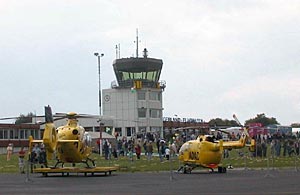 Willkommen
auf Deutschlands höchst
gelegenem Verkehrsflughafen! Zentral
positioniert zwischen Frankfurt, Köln
und Dortmund gibt es auf dem Flughafen
Siegerland eine Menge zu entdecken. Willkommen
auf Deutschlands höchst
gelegenem Verkehrsflughafen! Zentral
positioniert zwischen Frankfurt, Köln
und Dortmund gibt es auf dem Flughafen
Siegerland eine Menge zu entdecken.
Wir haben uns für eine neue Epoche im
Passagier- und Warenverkehr bestens
gerüstet und technische sowie organisatorische Voraussetzungen geschaffen,
damit unser Slogan "Starten vor der Haustür" eine ganz neue Qualität gewinnt.
Kurze Wege, Kundenfreundlichkeit, kostenlose Parkplätze sowie kurze Check
In-Zeiten sind nur einige Vorteile, die der Siegerland-Flughafen seinen Passagieren zu bieten hat.
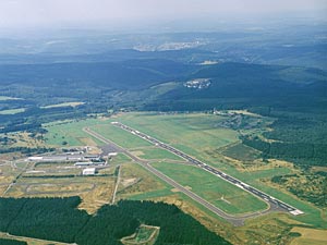 Der
Verkehrsflughafen Siegerland wurde 1967 von NRW-Minister-präsident
Kühn eröffnet. Der Flughafen Siegerland steht auf historischem
Terrain. Seit den dreißiger Jahren existierte hier ein militärisch
genutzter Landeplatz. In den 60-er Jahren entstanden mit Landebahn, Tower
und GAT die Grundlagen des heutigen Airports. Mit der Einführung
des Instrumentenflugverkehrs im Herbst 1999 bietet Deutschlands höchstgelegener
Verkehrsflughafen beste Perspektiven. Der
Verkehrsflughafen Siegerland wurde 1967 von NRW-Minister-präsident
Kühn eröffnet. Der Flughafen Siegerland steht auf historischem
Terrain. Seit den dreißiger Jahren existierte hier ein militärisch
genutzter Landeplatz. In den 60-er Jahren entstanden mit Landebahn, Tower
und GAT die Grundlagen des heutigen Airports. Mit der Einführung
des Instrumentenflugverkehrs im Herbst 1999 bietet Deutschlands höchstgelegener
Verkehrsflughafen beste Perspektiven.
 ICAO
Code EDGS ICAO
Code EDGS
IATA Code SGE
Name SIEGERLAND
Land Deutschland
Bundesland Nordrhein-Westfalen
Letzte Änderung 30. April 2005
Kategorie Verkehrsflughafen / Airport
Betreiber / Operator Siegerland Flughafen GmbH
Lage / Location 8.62 NM S Siegen
Nachtflug / NVFR NVFR
Instrumentenflug / IFR IFR
LFZ / ACFT Bis / up to PCN 53 F/D/X/T, über/more then 14000 kg PPR
Helicopter Ja / Yes
Motorsegler / GLDP Ja / Yes
Segelflugzeuge / GLD Ja / Yes
Ballone Ja / Yes
UL Ja / Yes
Luftsportgeräte/Flying sports products PPR
Summer Mon-Fri 0600-2000, Sat, Sun,HOL 0600-1900
Winter Mon-Fri 0700-2100, Sat, Sun, HOL 0700-SS+30
O/T PPR
Luftaufsicht / OPS +49 (0)2736 / 6844, Fax 50599
PPR +49 (0)2736 / 6844
AIS AIS-Centre EDDZ, +49 (0)69 / 78072500
ACC EDDF +49 (0)6103 / 7076200
MET (0190) 077223
Gafor 39
Zoll / Customs O / R 1 HR, Mon-Thu Anmeldung bis 1500 (1400), Abfertigung
Fri, Sat, Sun,O / R bis Fri 1300 (1200), HOL O / R am vorhergehenden Werktag
bis 1500 (1400). Für Ein-und Ausflüge im nichtgeweblichen Verkehr
oder im Gelegenheitsverkehr zur Personenbeförderung./Mon-Thu request
to be submitted until 1500 (1400) clearance Fri, Sat, Sun O / R until
preceding Fri 1300 (1200) HOL O / R on preceding workday until 1500 (1400)
For entries and exits of aircraft engaged in non-commercial traffic or
in non scheduled traffic for the transportation of passengers
Zoll / Customs Fon +49 (0)2736 / 6844, Fax 50599
Fuel 100 LL, Jet A1, Super bleifrei / unleaded
Oil 80, D 100, D 80, 15W50, Aero535
Hangar O/R
Höhe / Elevation 1966 ft / 599 m
FIS Langen Information 123.525, Siegerland ATIS 128.625
VDF / QDM 120.375
Rufzeichen / Call sign Siegerland Info
Frequenz Tower 120.375 122.500 EN/GE
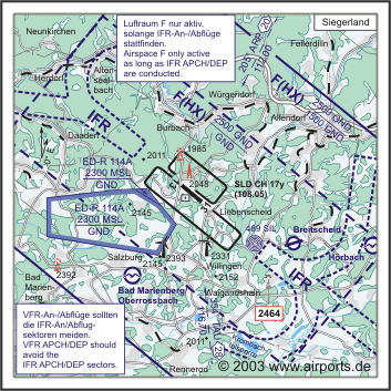
NAV Aids ILS RWY 31 108.900, ABN PAPI 310°/2.3 NM from SIL 489 104°/19
NM from COL 108.80 355°/28 NM from TAU 116.70 206°/20 NM from
ARP 112.00 DME SLD 108.05 am Platz/at field
Koordinaten 50 42, 46 N / 08 04, 98 E
Platzrunde / Traffic circuit SW 3000
Landebahnen / RWY 3
RWY 1620 x 30 m, ASPHALT/Antiskid
RWY 13 TKOF 1620 m; LDG 1620 m
RWY 31 TKOF 1620 m; LDG 1620 m
MTOW PCN 53 F/D/X/T
RWY II 600 x 30 m, Gras
RWY 13 TKOF 600 m; LDG 600 m
RWY 31 TKOF 600 m; LDG 600 m
MTOW RWY II 2000 kg
RWY III 500 x 30 m, GRAS
RWY 04 TKOF 500 m; LDG 500 m
RWY 22 TKOF 500 m; LDG 500 m
MTOW RWY III 1400 kg
Bemerkungen / Remarks Wohngebiete meiden!
Restaurant Ja
Adresse
Flughafenstr. 2
ZIP / City D-57299
Burbach
Fon +49 (0)2736 / 4140
Fax 41410
eMail info at siegerland-airport de
Internet: http://www.siegerland-airport.de/
Images and information placed above are from http://www.siegerland-airport.de/
http://www.airports.de/airport.php?ICAO=EDGS
We thank them for the data!
| General Info
|
| Country |
Germany
|
| ICAO ID |
EDGS
|
| Time |
UTC+1(+2DT)
|
| Latitude |
50.707658
50° 42' 27.57" N
|
| Longitude |
8.082969
008° 04' 58.69" E
|
| Elevation |
1966 feet
599 meters
|
| Type |
Civil
|
| Magnetic Variation |
000° E (01/05)
|
| Beacon |
Yes
|
| Operating Agency |
CIVIL GOVERNMENT, (LANDING FEES AND DIPLOMATIC CLEARANCE MAY BE REQUIRED)
|
| Near City |
Siegen
|
| Operating Hours |
SEE REMARKS FOR OPERATING HOURS OR COMMUNICATIONS FOR POSSIBLE HOURS
|
| Daylight Savings Time |
Last Sunday in March to last Sunday in October
|
| Communications
|
| LANGEN RADAR |
124.9
|
| LANGEN INFO |
123.525
|
| ATIS |
128.625
|
| INFO |
120.375
|
| Runways
|
ID
|
Dimensions |
Surface |
PCN |
ILS
|
| 04/22 |
1640 x 98 feet
500 x 30 meters |
GRASS OR EARTH NOT GRADED OR ROLLED. |
- |
NO
|
| 13/31 |
5315 x 98 feet
1620 x 30 meters |
ASPHALT |
053FDXT |
YES
|
| 13L/31R |
1969 x 98 feet
600 x 30 meters |
GRASS OR EARTH NOT GRADED OR ROLLED. |
- |
NO
|
| Navaids
|
| Type |
ID |
Name |
Channel |
Freq |
Distance From Field |
Bearing From Navaid
|
| NDB |
SIL |
SIEGERLAND |
- |
489 |
2.7 NM |
307.8
|
| DME |
SLD |
SIEGERLAND |
017Y |
- |
At Field |
-
|
| Supplies/Equipment
|
| Fuel |
Jet A1, without icing nhibitor.
100/130 MIL Spec, low lead, aviation gasoline (BLUE)
|
| Oil |
O-117, 1100, Reciprocating Engine Oil (MIL L 6082)
O-123, 1065,(Dispersant)Reciprocating Engine Oil(MIL L 22851 Type III)
|
| Remarks
|
| CSTMS/IMG |
Avbl O/R 1hr.
|
| FLUID |
De-Ice avbl.
|
| FUEL |
(NC-100LL, A1)
|
| LGT |
ABn flg W.
|
| OPR HOURS |
Opr 0700-2100Z++ Mon-Fri; 0700Z++-SS+30 Sat, Sun and hol; OT PPR.
|
| RSTD |
PPR to acft over AUW31. PPR for IFR flt Sat, Sun and hol.
|
Runway 04/22
1640 x 98 feet
500 x 30 meters
| Runway 04
|
| Surface |
GRASS OR EARTH NOT GRADED OR ROLLED.
|
| True Heading |
038.0
|
| Latitude |
50.703194
50° 42' 11.50" N
|
| Longitude |
8.084056
008° 05' 02.60" E
|
| Landing Distance |
1640 feet
500 meters
|
| Takeoff Distance |
1640 feet
500 meters
|
| Runway 22
|
| Surface |
GRASS OR EARTH NOT GRADED OR ROLLED.
|
| True Heading |
218.0
|
| Latitude |
50.706750
50° 42' 24.30" N
|
| Longitude |
8.088444
008° 05' 18.40" E
|
| Landing Distance |
1640 feet
500 meters
|
| Takeoff Distance |
1640 feet
500 meters
|
Runway 13/31
5315 x 98 feet
1620 x 30 meters
| Runway 13
|
| Surface |
ASPHALT
|
| True Heading |
128.0
|
| Latitude |
50.712758
50° 42' 45.93" N
|
| Longitude |
8.072675
008° 04' 21.63" E
|
| Elevation |
1961.0 feet
598 meters
|
| Slope |
-0.6°
|
| Landing Distance |
5315 feet
1620 meters
|
| Takeoff Distance |
5315 feet
1620 meters
|
| Lighting System |
CL
HIRL
REIL
T
PAPI |
| Runway 31
|
| Surface |
ASPHALT
|
| True Heading |
308.0
|
| Latitude |
50.703789
50° 42' 13.64" N
|
| Longitude |
8.090728
008° 05' 26.62" E
|
| Elevation |
1928.0 feet
588 meters
|
| Slope |
0.6°
|
| Landing Distance |
5315 feet
1620 meters
|
| Takeoff Distance |
5315 feet
1620 meters
|
| Lighting System |
SF
CL
HIRL
REIL
A1
PAPI |
Navaids
| SIEGERLAND
|
| Type |
ID |
Channel |
Freq |
Country |
State
|
| NDB |
SIL |
- |
489 |
Germany |
-
|
| Latitude |
Longitude |
Airport
|
50.680033
50° 40' 48.12" N |
8.138497
008° 08' 18.59" E |
EDGS |
Navaids
| SIEGERLAND
|
| Type |
ID |
Channel |
Freq |
Country |
State
|
| DME |
SLD |
017Y |
- |
Germany |
-
|
| Latitude |
Longitude |
Airport
|
50.706769
50° 42' 24.37" N |
8.078511
008° 04' 42.64" E |
EDGS |
The content above was published at Airports-Worldwide.com in 2005.
We don't guarantee the information is fresh and accurate. The data may be wrong or outdated.
For more up-to-date information please refer to other sources.
|
|


