 |
|
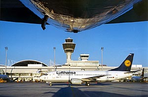
München International Airport |
 Start
of operations Start
of operations
October 1939 (Munich-Riem Airport)
May 17, 1992 (Munich - Franz Josef Strauß Airport)
June 29, 2003 Terminal 2
Location
28.5 kilometers north-east of the center of Munich,
the Bavarian Capital, at 448 meters above sea level (NN)
Airport reference point
48° 21' 17'' North
11° 47' 15'' East
Area
1500 hectares, of which 1100 is greened
(approximately 70% of the total area)
Airport operating company
Flughafen München GmbH
Shareholders
The Free State of Bavaria (51%),
The Federal Republic of Germany (26 %),
The City of Munich (23 %)
Runways
Two parallel runways, 4,000 meters long and 60 meters wide, 2,300 meters
distance between the axes, staggered by 1,500 meters
 Aprons Aprons
Passenger Apron West:
Area: 600,000 sqm
60 aircraft parking positions
19 passenger bridges clese to the Terminal 1
14 Boarding Stations
Passenger Apron East.
Area: 760,000 sqm
75 aircraft parking positions
24 passenger bridges close to the Terminal 2
4 stans for regional jets
47 Boarding Stations
Airfreight/airmail:
Area: 66,500 sqm
14 aircraft parking positions
General aviation:
Area: 120,000 sqm
50 aircraft parking positions
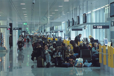
Terminal
Terminal 1
Capacity: over 20 million passengers per year
Length: 1,081 meters
Total floor area: 198,000 sqm
Areas A-D for arrivals and departures, Area E for arrivals only
Number of check-in counters: 150
Baggage conveyor system
Total length: 18 kilometers
Capacity: 19,200 pieces of luggage per hour
Baggage claim conveyors: 14
Terminal 2
Capacity: over 20-25 million passengers per year
Pierlength: 980 meters
Total floor area: 260,000 sqm
Level 03: Arrivals
Level 04/05: Departures
Number of check-in counters: 124
Baggage conveyor system
Total length: 40 kilometers
Capacity: 14,000 pieces of luggage per hour
Baggage claim conveyors: 14
Central Area
Underground S-Bahn rail station
Total floor area: 46,000 sqm
Number of check-in counters: 37
Parking Areas
four multi-storey car parks
six underground car parks
parking areas for vacationists and visitors with a total of 20,000 parking
spaces, of which approx. 16,500 are covered parking spaces
ICAO Code EDDM
IATA Code MUC
Name MÜNCHEN
Land Deutschland
Bundesland Bayern
Letzte Änderung 12. November 2003
Kategorie Int. Verkehrsflughafen / Int. Airport
Betreiber / Operator Flughafen München GmbH
Lage / Location 15.4 NM NE Stadtmitte/Centre München
Nachtflug / NVFR NVFR
Instrumentenflug / IFR IFR
LFZ / ACFT Bis / up to PCN 90 R/A/W/T
Helicopter Ja / Yes
Benutzung des Flughafens mit LFZ bis 2000 kg und für VFR Flüge
nur PPR bei Flughafen München GmbH, EXC HEL. DEP/ARR nur nach vorheriger
Zuteilung einer Start-oder Landezeit durch den Flugplankoordinator/ACFT
of up to and including 2000 kg maximum take off mass and ACFT flying according
to VFR are permitted to use te AD only after PPR by the Flughafen München
GmbH, EXC HEL. DEP/ARR only after prior allocation of a time of departure
or arrivel by the Schedulung Coordinator: FAC2-Terminal 2 Bereich E, HBK
37, 60549 Frankfurt/Main, Tel +49 (0)69 / 73360 /61 /63
Summer H 24, CTR H 24
Winter H 24, CTR H 24
PPR +49 (0)69 / 73360 /61 /63
AIS AIS-Centre +49 (0)69 / 78072500
MET (0190) 077225
Gafor 82
Zoll / Customs H 24
Fuel 100 LL, Jet A1
Oil Turbo oils and aviation oils
Hangar O / R
Höhe / Elevation 1487 ft / 453 m
FIS München Information 120.650, 126.950
VDF / QDM O/R
Rufzeichen / Call sign München Tower/Turm
Frequenz Tower Nord/North 118.700 Süd/South 120.500
Frequenz Ground Nord/North 121.975 Süd/South 121.825
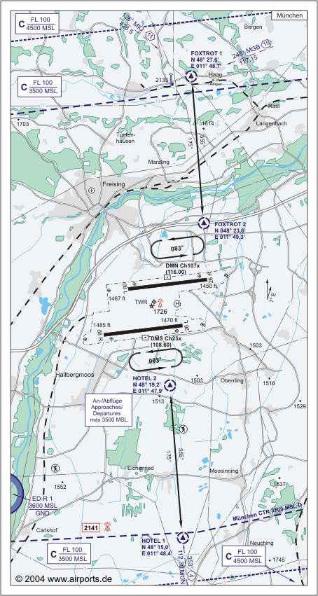
NAV Aids ABN PAPI DME DMN 116.00/DMS 108.60 ILS RWY 26R 108.70 ILS RWY
26L 108.30 ILS RWY 08R 110.90 ILS RWY 08 L 110.30
Koordinaten 48 21, 23 N / 11 47, 17 E
Landebahnen / RWY 2
RWY 4000 x 60 m, CONCRETE
RWY 08L TKOF 4000 m; LDG 4000 m
RWY 26R TKOF 4000 m; LDG 4000 m
MTOW 90 R/A/W/T
RWY II 4000 x 60 m, CONCRETE
RWY 08R TKOF 4000 m; LDG 4000 m
RWY 26L TKOF 4000 m; LDG 4000 m
MTOW RWY II 90 R/A/W/T
Restaurant Ja
Adresse
Postfach 231755
ZIP / City D-85326 München
Fon +49 (0)89 / 97521199
URL http://www.munich-airport.de
Images and information placed
above are from http://www.airports.de/airport.php?ICAO=EDDM
http://www.munich-airport.de
We thank them for the data!
| General Info
|
| Country |
Germany
|
| ICAO ID |
EDDM
|
| Time |
UTC+1(+2DT)
|
| Latitude |
48.353783
48° 21' 13.62" N
|
| Longitude |
11.786086
011° 47' 09.91" E
|
| Elevation |
1487 feet
453 meters
|
| Type |
Civil
|
| Magnetic Variation |
001° E (01/05)
|
| Beacon |
Yes
|
| Operating Agency |
CIVIL GOVERNMENT, (LANDING FEES AND DIPLOMATIC CLEARANCE MAY BE REQUIRED)
|
| Alternate Name |
MUNICH
|
| Operating Hours |
NO OPERATING HOURS LISTED
|
| International Clearance Status |
Airport of Entry
|
| Daylight Savings Time |
Last Sunday in March to last Sunday in October
|
| Communications
|
| TWR |
118.7
120.5
119.4
337.75
(118.7 N Rwy 08L-26R)(120.5 S Rwy 08R-26L)(119.4 altn)
|
| APRON |
121.7
121.775
121.925
|
RADAR
Opr SR-30-SS+30.
|
131.225
241.95
(Flt in Class C)
|
| INFO |
120.65
126.95
|
| GND |
121.975
121.825
119.4
(121.975 N Rwy 08L-26R)(121.825 S Rwy 08R-26L)(119.4 altn)
|
| DIRECTOR |
118.825
279.6
|
| CLNC DEL |
121.725
119.4
337.75
(Initial call and start-up req)(119.4 altn)
|
ATIS
Opr 0320-2250Z++.
|
123.125
|
| APP |
120.775
128.025
279.6
249.85
(128.025 North FL95-FL195)(120.775 South FL95-FL195)(249.85 Alt)
|
| RADAR |
123.9
127.95
279.6
249.85
(123.9 North blw FL95)(127.95 South blw FL95)(249.85 altn)
|
| Communications Remarks |
|
| TWR |
Copters - dep N use 118.7, dep S use 120.5)
|
| Runways
|
ID
|
Dimensions |
Surface |
PCN |
ILS
|
| 08R/26L |
13123 x 197 feet
4000 x 60 meters |
CONCRETE. |
090RAWT |
YES
|
| 08L/26R |
13123 x 197 feet
4000 x 60 meters |
CONCRETE. |
090RAWT |
YES
|
| Navaids
|
| Type |
ID |
Name |
Channel |
Freq |
Distance From Field |
Bearing From Navaid
|
| VOR-DME |
MUN |
MUNCHEN |
070X |
112.3 |
10.5 NM |
352.0
|
| NDB |
MSW |
MUNCHEN |
- |
400 |
4.7 NM |
269.6
|
| DME |
DMS |
MUNCHEN |
023X |
- |
At Field |
-
|
| Supplies/Equipment
|
| Fuel |
Jet A1, without icing nhibitor.
100/130 MIL Spec, low lead, aviation gasoline (BLUE)
|
| Other Fluids |
PRESAIR, Air Compressors rated 3,000PSI or more
OX, Indicates oxygen servicing when type of servicing is unknown
|
| Remarks
|
| CAUTION |
For apch and dep to/fr helipad ctc ATC for ldg and ovft instr.
|
| FLUID |
OX PRESAIR
|
| FUEL |
A1 (TFE Deutschland) avbl 0600-0100Z++, fone C49-211-90 57-325; aft hr call bus fone. (NC-100LL)
|
| LGT |
ABn flg W. PAPI Rwy 08L MEHT 55', PAPI Rwy 26L MEHT 53', PAPI Rwy 08R MEHT 53',PAPI Rwy 26R MEHT 55'.
|
| MISC |
Call De-Ice coord at least 15 min prior to off-block.
|
| NS ABTMT |
On ldg use reverse thrust only to extent of safety.
|
| RSTD |
F/W acft under 4410 lb and F/W VFR acft PPR. No multi apch and dep 1100Z++ Sat-0500Z++ Mon and hol, OT PPR. 2100-0500Z++ dly sked and PPR OPS only. Max wgspan Twy D6, Ramp 10, Ramp 11 98'.
|
Runway 08R/26L
13123 x 197 feet
4000 x 60 meters
| Runway 08R
|
| Surface |
CONCRETE.
|
| True Heading |
083.0
|
| Latitude |
48.340669
48° 20' 26.41" N
|
| Longitude |
11.751017
011° 45' 03.66" E
|
| Elevation |
1486.0 feet
453 meters
|
| Slope |
-0.1°
|
| Landing Distance |
13123 feet
4000 meters
|
| Takeoff Distance |
13123 feet
4000 meters
|
| Lighting System |
SF
TDZL
CL
HIRL
REIL
A1
PAPI |
| Runway 26L
|
| Surface |
CONCRETE.
|
| True Heading |
263.0
|
| Latitude |
48.344797
48° 20' 41.27" N
|
| Longitude |
11.804614
011° 48' 16.61" E
|
| Elevation |
1470.0 feet
448 meters
|
| Slope |
0.1°
|
| Landing Distance |
13123 feet
4000 meters
|
| Takeoff Distance |
13123 feet
4000 meters
|
| Lighting System |
SF
TDZL
CL
HIRL
REIL
A1
PAPI |
Runway 08L/26R
13123 x 197 feet
4000 x 60 meters
| Runway 08L
|
| Surface |
CONCRETE.
|
| True Heading |
083.0
|
| Latitude |
48.362767
48° 21' 45.96" N
|
| Longitude |
11.767550
011° 46' 03.18" E
|
| Elevation |
1467.0 feet
447 meters
|
| Slope |
-0.1°
|
| Landing Distance |
13123 feet
4000 meters
|
| Takeoff Distance |
13123 feet
4000 meters
|
| Lighting System |
SF
TDZL
CL
HIRL
REIL
A1
PAPI |
| Runway 26R
|
| Surface |
CONCRETE.
|
| True Heading |
263.0
|
| Latitude |
48.366886
48° 22' 00.79" N
|
| Longitude |
11.821172
011° 49' 16.22" E
|
| Elevation |
1449.0 feet
442 meters
|
| Slope |
0.1°
|
| Landing Distance |
13123 feet
4000 meters
|
| Takeoff Distance |
13123 feet
4000 meters
|
| Lighting System |
SF
TDZL
CL
HIRL
REIL
A1
PAPI |
Navaids
| MUNCHEN
|
| Type |
ID |
Channel |
Freq |
Country |
State
|
| VOR-DME |
MUN |
070X |
112.3 |
Germany |
-
|
| Latitude |
Longitude |
Airport
|
48.180325
48° 10' 49.17" N |
11.816017
011° 48' 57.66" E |
EDDM |
Navaids
| MUNCHEN
|
| Type |
ID |
Channel |
Freq |
Country |
State
|
| NDB |
MSW |
- |
400 |
Germany |
-
|
| Latitude |
Longitude |
Airport
|
48.352378
48° 21' 08.56" N |
11.903767
011° 54' 13.56" E |
EDDM |
Navaids
| MUNCHEN
|
| Type |
ID |
Channel |
Freq |
Country |
State
|
| DME |
DMS |
023X |
- |
Germany |
-
|
| Latitude |
Longitude |
Airport
|
48.340689
48° 20' 26.48" N |
11.778169
011° 46' 41.41" E |
EDDM |
The content above was published at Airports-Worldwide.com in 2005.
We don't guarantee the information is fresh and accurate. The data may be wrong or outdated.
For more up-to-date information please refer to other sources.
|
|


