 |
 |
|
||||
|
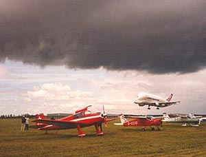
Military GAM (Bundeswehr Heeresflieger)
Laupheim is a small town with 18460 inhabitants. The size is about 61,78 km². Laupheim has some big firms like Kässbohrer, Aircabin, and Hamann Motorsports. Kässboher is building machines called PistenBully. Aircabin builds cabins for airplanes. It is a subsidiary firm of Airbus. Hamann is one of the best known tuning firms worldwide. They are tuning all kind of expensive cars like BMW, Porsche, Ferrari and Mercedes. They specialize in motor tuning.
Until 1806, Laupheim was a small state (about five miles in diameter) within the Holy Roman Empire. It was a Lordship (Reichsritterschaft) ruled by an Imperial Knight. In 1806 it was annexed by the Kingdom of Württemberg, and in 1871 it became part of the Empire of Germany.
Photos by Joachim Musehold Images and information placed above are from http://www.boelkow-junior.de/d/Laupheim_Musehold.html We thank them for the data!
Runway 03/211968 x 164 feet
|
|||||||||||||||||||||||||||||||||||||||||||||||||||||||||||||||||||||||||||||||||||||||||||||||||||||||||||||||||||||||||||||||||||||||||||||||||||||||||||||||||||||||||||||||||||||||||||||||||||||||||||||||||||||||||||||
| Runway 03 | |
|---|---|
| Surface | GRASS OR EARTH NOT GRADED OR ROLLED. |
| True Heading | 034.0 |
| Latitude | 48.221239 48° 13' 16.46" N |
| Longitude | 9.903878 009° 54' 13.96" E |
| Landing Distance | 1968 feet 600 meters |
| Takeoff Distance | 1968 feet 600 meters |
| Runway 21 | |
|---|---|
| Surface | GRASS OR EARTH NOT GRADED OR ROLLED. |
| True Heading | 214.0 |
| Latitude | 48.225828 48° 13' 32.98" N |
| Longitude | 9.908358 009° 54' 30.09" E |
| Landing Distance | 1968 feet 600 meters |
| Takeoff Distance | 1968 feet 600 meters |
| Runway 09 | |
|---|---|
| Surface | ASPHALT |
| True Heading | 093.0 |
| Latitude | 48.220667 48° 13' 14.40" N |
| Longitude | 9.898958 009° 53' 56.25" E |
| Elevation | 1761.0 feet 537 meters |
| Slope | 0.1° |
| Landing Distance | 5400 feet 1646 meters |
| Takeoff Distance | 5400 feet 1646 meters |
| Lighting System | HIRL |
| Runway 27 | |
|---|---|
| Surface | ASPHALT |
| True Heading | 273.0 |
| Latitude | 48.219928 48° 13' 11.74" N |
| Longitude | 9.921081 009° 55' 15.89" E |
| Elevation | 1765.0 feet 538 meters |
| Slope | -0.1° |
| Landing Distance | 5400 feet 1646 meters |
| Takeoff Distance | 5400 feet 1646 meters |
| Lighting System | SF
HIRL BP |
| LAUPHEIM | |||||
|---|---|---|---|---|---|
| Type | ID | Channel | Freq | Country | State |
| NDB | LUP | - | 407 | Germany | - |
| Latitude | Longitude | Airport |
| 48.218042 48° 13' 04.95" N |
9.910872 009° 54' 39.14" E |
ETHL |
The content above was published at Airports-Worldwide.com in 2005.
We don't guarantee the information is fresh and accurate. The data may be wrong or outdated.
For more up-to-date information please refer to other sources.

 |
|
Copyright 2004-2026 © by Airports-Worldwide.com, Vyshenskoho st. 36, Lviv 79010, Ukraine Legal Disclaimer |
 Laupheim
is a town in the district of Biberach, Baden-Württemberg, Germany.
Laupheim
is a town in the district of Biberach, Baden-Württemberg, Germany.
 Laupheim
is also the home of a well known Breakdance group called United Styles.
Laupheim
is also the home of a well known Breakdance group called United Styles.