|
 |
|
||||
|
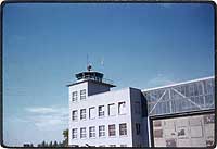
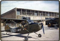
Kitzingen AAF (Harvey Bks) Opened before 1945 Airfield military - USAR (US Army)
Images and information placed above are from http://www.usarmygermany.com/ We thank them for the data!
Runway 07/252625 x 100 feet
|
||||||||||||||||||||||||||||||||||||||||||||||||||||||||||||||||||||||||||||||||||||||||||||||||||||||||||||||||||||||||||||||||||||||||||||||||||||||||||||||||||||||||||||||||||||||||||||
| Runway 07 | |
|---|---|
| Surface | CONCRETE. |
| True Heading | 065.0 |
| Latitude | 49.741539 49° 44' 29.54" N |
| Longitude | 10.195525 010° 11' 43.89" E |
| Elevation | 645.0 feet 197 meters |
| Slope | 1.7° |
| Landing Distance | 2625 feet 800 meters |
| Takeoff Distance | 2825 feet 861 meters |
| Overrun Length | 200 feet 61 meters |
| Overrun Surface | GRASS OR EARTH NOT GRADED OR ROLLED. |
| Runway 25 | |
|---|---|
| Surface | CONCRETE. |
| True Heading | 245.0 |
| Latitude | 49.744578 49° 44' 40.48" N |
| Longitude | 10.205586 010° 12' 20.11" E |
| Elevation | 689.0 feet 210 meters |
| Slope | -1.7° |
| Landing Distance | 2625 feet 800 meters |
| Takeoff Distance | 2825 feet 861 meters |
| Overrun Length | 200 feet 61 meters |
| Overrun Surface | GRASS OR EARTH NOT GRADED OR ROLLED. |
| KITZINGEN | |||||
|---|---|---|---|---|---|
| Type | ID | Channel | Freq | Country | State |
| VOR | KTG | - | 111.4 | Germany | - |
| Latitude | Longitude | Airport |
| 49.745889 49° 44' 45.20" N |
10.213639 010° 12' 49.10" E |
ETIN |
The content above was published at Airports-Worldwide.com in 2005.
We don't guarantee the information is fresh and accurate. The data may be wrong or outdated.
For more up-to-date information please refer to other sources.

 |
|
Copyright 2004-2026 © by Airports-Worldwide.com, Vyshenskoho st. 36, Lviv 79010, Ukraine Legal Disclaimer |