 |
|
ICAO Code EDAH
IATA Code HDF
Name HERINGSDORF
Land Deutschland
Bundesland Mecklenburg-Vorpommern
Letzte Änderung 11. November 2004
Kategorie Verkehrsflughafen / Airport
Betreiber / Operator Flughafen Heringsdorf GmbH
Lage / Location 4 NM S Seebad/Seaside resort of Heringsdorf Insel/ Isle
of Usedom
Nachtflug / NVFR NVFR
Instrumentenflug / IFR IFR
LFZ / ACFT Bis / up to PCN 38
Helicopter Ja / Yes
Motorsegler / GLDP Ja / Yes
UL Ja / Yes
andere Flugzeuge/other aeroplanes PPR
Summer 0600-1800, CTR MON-FRI täglich/daily0630-0800+1030-1400
Winter 0700-SS/1600, CTR MON-FRI täglich/daily 0730-0900+1130-1500
O/T PPR
Luftaufsicht / OPS +49 (0)38376 / 20398, 25032, Fax 25043
AIS EDDB +49 (0)30 / 60918250
MET (0190) 077222
Gafor 12
Zoll / Customs O / R, Zoll- und Paßabfertigung für nicht gewerblichen
Verkehr und gewerblichen Gelegenheitsverkehr/Customs and immigrtion clearance
for non-commercial and non scheduled commercial traffic.
Fuel 100 LL, Jet A1
Oil Turbo-Öl/oil, Aviation-Öl/oil, EE 100, EE 80
Hangar Nein / No
Höhe / Elevation 93 ft / 28 m
FIS Berlin Information 126.350
VDF / QDM 132.825
Rufzeichen / Call sign Heringsdorf Tower/Turm Heringsdorf Info
Frequenz Tower 132.825 EN/GE
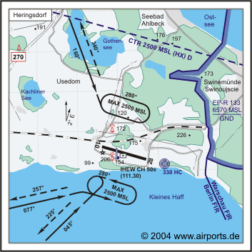
NAV Aids NDB HC 330 284°/0.6 NM TO THR 28 070°/22 NM from FLD
VOR 115.60 136°/45 NM from TRT VOR/DME 108.45/Ch 21y
Koordinaten 53 52, 72 N / 14 09, 14 E
Platzrunde / Traffic circuit 1100
Landebahnen / RWY 1
RWY 2305 x 35 m, ASPHALT
RWY 10 TKOF 2305 m; LDG 2305 m
RWY 28 TKOF 2305 m; LDG 2305 m
MTOW PCN 38 F/A/X/T
Bemerkungen / Remarks TWR*/CTR:0800-1000 (0700-0900)+ 1300-1600 (1200-1500)
OT INFO! Warschau FIR 1.6 NM E des Platzes! Wohngebiete meiden! UL acft
PPR!
Restaurant - Yes
Adresse
Flughafen
ZIP / City D-17419 Zirchow
Fon +49 (0)38376 / 2500
Fax 25033
WWW: Heringsdorf
Airport
Images and information placed
above are from
http://www.airports.de/airport.php?ICAO=EDAH
We thank them for the data!
| General Info
|
| Country |
Germany
|
| ICAO ID |
EDAH
|
| Time |
UTC+1(+2DT)
|
| Latitude |
53.878706
53° 52' 43.34" N
|
| Longitude |
14.152347
014° 09' 08.45" E
|
| Elevation |
93 feet
28 meters
|
| Type |
Civil
|
| Magnetic Variation |
002° E (01/05)
|
| Beacon |
Yes
|
| Operating Agency |
CIVIL GOVERNMENT, (LANDING FEES AND DIPLOMATIC CLEARANCE MAY BE REQUIRED)
|
| Alternate Name |
GARZ
|
| Operating Hours |
SEE REMARKS FOR OPERATING HOURS OR COMMUNICATIONS FOR POSSIBLE HOURS
|
| Daylight Savings Time |
Last Sunday in March to last Sunday in October
|
| Communications
|
TWR
Opr 0900-1030Z++, 1130-1500Z++, OT PPR.
|
132.825
119.7
Usable only up to 25 NM, 4000 ft.
|
| INFO |
132.825
|
| BERLIN INFO |
126.35
|
| Runways
|
ID
|
Dimensions |
Surface |
PCN |
ILS
|
| 10/28 |
7545 x 115 feet
2300 x 35 meters |
ASPHALT |
038FAXT |
YES
|
| 10R/28L |
1969 x 98 feet
600 x 30 meters |
GRASS OR EARTH NOT GRADED OR ROLLED. |
- |
NO
|
| Navaids
|
| Type |
ID |
Name |
Channel |
Freq |
Distance From Field |
Bearing From Navaid
|
| NDB |
HC |
HERINGSDORF |
- |
330 |
1.1 NM |
282.6
|
| Supplies/Equipment
|
| Fuel |
Jet A1, without icing nhibitor.
100/130 octane gasoline, leaded, MIL-L-5572F (GREEN)
|
| Oil |
Available (Types unknown)
|
| Remarks
|
| CAUTION |
Gldr act.
|
| CSTMS/IMG |
Avbl O/R.
|
| FUEL |
(NC-100LL, A1)
|
| LGT |
PAPI Rwy 10-28 MEHT 51'.
|
| MISC |
Class D Airspace eff twr hrs, OT Class E.
|
| OPR HOURS |
Opr 0700Z-1600Z or SS; (0600-1800Z DT), OT PPR.
|
| RSTD |
PPR to F/W acft.
|
Runway 10/28
7545 x 115 feet
2300 x 35 meters
| Runway 10
|
| Surface |
ASPHALT
|
| True Heading |
106.0
|
| Latitude |
53.881631
53° 52' 53.87" N
|
| Longitude |
14.134503
014° 08' 04.21" E
|
| Elevation |
77.0 feet
23 meters
|
| Slope |
0.2°
|
| Landing Distance |
7545 feet
2300 meters
|
| Takeoff Distance |
7545 feet
2300 meters
|
| Lighting System |
HIRL
BO
PAPI |
| Runway 28
|
| Surface |
ASPHALT
|
| True Heading |
286.0
|
| Latitude |
53.876092
53° 52' 33.93" N
|
| Longitude |
14.168189
014° 10' 05.48" E
|
| Elevation |
89.0 feet
27 meters
|
| Slope |
-0.2°
|
| Landing Distance |
7545 feet
2300 meters
|
| Takeoff Distance |
7545 feet
2300 meters
|
| Lighting System |
HIRL
BO
PAPI |
Runway 10R/28L
1969 x 98 feet
600 x 30 meters
| Runway 10R
|
| Surface |
GRASS OR EARTH NOT GRADED OR ROLLED.
|
| True Heading |
105.6
|
| Latitude |
53.879633
53° 52' 46.68" N
|
| Longitude |
14.142081
014° 08' 31.49" E
|
| Landing Distance |
1969 feet
600 meters
|
| Takeoff Distance |
1969 feet
600 meters
|
| Runway 28L
|
| Surface |
GRASS OR EARTH NOT GRADED OR ROLLED.
|
| True Heading |
285.6
|
| Latitude |
53.878144
53° 52' 41.32" N
|
| Longitude |
14.151081
014° 09' 03.89" E
|
| Landing Distance |
1969 feet
600 meters
|
| Takeoff Distance |
1969 feet
600 meters
|
Navaids
| HERINGSDORF
|
| Type |
ID |
Channel |
Freq |
Country |
State
|
| NDB |
HC |
- |
330 |
Germany |
-
|
| Latitude |
Longitude |
Airport
|
53.874064
53° 52' 26.63" N |
14.182061
014° 10' 55.42" E |
EDAH |
The content above was published at Airports-Worldwide.com in 2005.
We don't guarantee the information is fresh and accurate. The data may be wrong or outdated.
For more up-to-date information please refer to other sources.
|
|


