Hamburg Finkenwerder Airfield |
 ICAO Code EDHI
IATA Code XFW
Name HAMBURG - Finkenwerder
Land Deutschland
Bundesland Hamburg
Letzte Änderung 8. Dezember 2004
Kategorie Sonderlandeplatz / Special Airfield
Betreiber / Operator Daimler-Benz Aerospace Airbus GmbH
Lage / Location 5.4 NM WSW Hamburg
Nachtflug / NVFR NVFR
Instrumentenflug / IFR IFR
LFZ / ACFT Bis / up to PCN 110
Helicopter Ja / Yes
Summer PPR 24 HR
Winter PPR 24 HR
O/T PPR 24 HR
Luftaufsicht / OPS +49 (0)40 / 74372228, Fax 74373783
PPR +49 (0)40 / 74372228, Fax 74373783, 7426643
AIS AIS-Centre +49 (0)69 / 78072500
MET (0190) 077221
Gafor 3
Zoll / Customs PPR
Zoll / Customs Fon +49 (0)40 / 7426643, 74372228
Fuel Jet A1
Oil Esso 2380, Mobil Jet II, Aero Shell 500, Castrol 98 oder/or 205
Hangar O / R
Höhe / Elevation 21 ft / 7 m
FIS Bremen Information 125.100
Rufzeichen / Call sign Finkenwerder Turm
Frequenz Tower 123.250 EN / GE
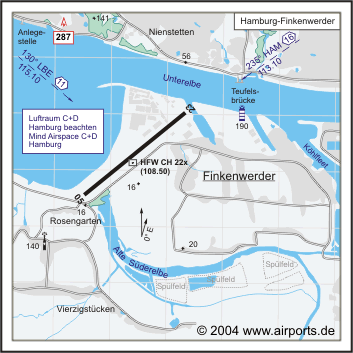
NAV Aids 130°/11 NM from LBE VOR/DME 115.10 235°/16 NM from HAM
VORTAC 113.10/Ch 78
Koordinaten 53 32, 12 N / 09 50, 13 E
Platzrunde / Traffic circuit
Landebahnen / RWY 1
RWY 2630 x 45 m, ASPHALT
RWY 05 TKOF 2530 m; LDG 2526 m
RWY 23 TKOF 2526 m; LDG 1875 m
MTOW PCN 110
Bemerkungen / Remarks Airspace C Hamburg (2500 MSL/FL 60) Frequenz: 125.100!
CTR Hamburg (2500 MSL)
Adresse Kreetslag 10
ZIP / City D-21129 Hamburg
Fon +49 (0)40 / 74370
Fax 7434422
WWW: Hamburg Finkenwerder Airfield
Images and information placed
above are from
http://www.airports.de/airport.php?ICAO=EDHI
We thank them for the data!
| General Info
|
| Country |
Germany
|
| ICAO ID |
EDHI
|
| Time |
UTC+1(+2DT)
|
| Latitude |
53.535886
53° 32' 09.19" N
|
| Longitude |
9.837025
009° 50' 13.29" E
|
| Elevation |
21 feet
6 meters
|
| Type |
Civil
|
| Magnetic Variation |
001° E (01/05)
|
| Operating Agency |
PRIVATE
|
| Daylight Savings Time |
Last Sunday in March to last Sunday in October
|
| Communications
|
| FINKENWERDER TWR |
123.25
259.15
|
| BREMEN INFO |
125.1
376.7
|
| Runways
|
ID
|
Dimensions |
Surface |
PCN |
ILS
|
| 05/23 |
8628 x 148 feet
2630 x 45 meters |
ASPHALT |
- |
YES
|
| Supplies/Equipment
|
| Fuel |
Jet A1, without icing nhibitor.
|
| Remarks
|
| CAUTION |
Dng of hydroplaning off asphalt portion of rwy. Cranes NW side of rwy to 210' AGL. Tkof position displaced from end of rwy 23 to turning pad btn twy E and twy Ftil 1 May 05.
|
| CSTMS/AG/IMG |
Avbl PPR C040-7426643, 74372228.
|
| FUEL |
(NC-A1)
|
| LGT |
PAPI Rwy 05 GS 3.1 .
|
| MISC |
Fst 4482' Rwy 23 conc.
|
| RSTD |
PPR H24. Fone C040-7437-2228.
|
Runway 05/23
8628 x 148 feet
2630 x 45 meters
| Runway 05
|
| Surface |
ASPHALT
|
| True Heading |
052.0
|
| Latitude |
53.528564
53° 31' 42.83" N
|
| Longitude |
9.821486
009° 49' 17.35" E
|
| Elevation |
16.0 feet
5 meters
|
| Slope |
0.0°
|
| Landing Distance |
8287 feet
2526 meters
|
| Takeoff Distance |
8628 feet
2630 meters
|
| Displaced Threshold Length |
341 feet
104 meters
|
| Lighting System |
SF
CL
LIRL
REIL
BO
PAPI |
| Runway 23
|
| Surface |
ASPHALT
|
| True Heading |
232.0
|
| Latitude |
53.543256
53° 32' 35.72" N
|
| Longitude |
9.852656
009° 51' 09.56" E
|
| Elevation |
15.0 feet
5 meters
|
| Slope |
0.0°
|
| Landing Distance |
6154 feet
1876 meters
|
| Takeoff Distance |
8793 feet
2680 meters
|
| Displaced Threshold Length |
2474 feet
754 meters
|
| Overrun Length |
165 feet
50 meters
|
| Overrun Surface |
CONCRETE.
|
| Lighting System |
SF
CL
HIRL
REIL
BO
PAPI |
The content above was published at Airports-Worldwide.com in 2005.
We don't guarantee the information is fresh and accurate. The data may be wrong or outdated.
For more up-to-date information please refer to other sources.
|


