|
 |
|
||||
|
The castle of Bückeburg was once the residence of the princes. Even today the princes of Schaumburg-Lippe live there, but of course without political power. The interior of the castle has impressive furnishing. Nearby is the mausoleum of the princes' family, which was built in 1915. It resembles a smaller copy of the Roman Pantheon. In Bückeburg there is also a helicopter museum, exposing the early drawings of flying objects by Leonardo da Vinci as well as 40 genuine helicopters. German Army's Light Aviation School ( or "Heeresfliegerwaffenschule" ) is established at Bückeburg-Achum airfield since January 13, 1960. Both military pilots and technicians get their training there.Pilots who are training on Bo 105's, EC135's, UH-1D's or CH-53G's usually fly to some nearby training fields. This allows them to train in different terrain configurations and avoid helicopter flight concentration being too close to Bückeburg.
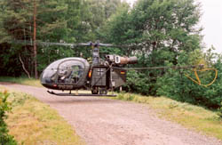
The Alouette II is today the oldest operational helicopter in service at the German Army. In the past, this type of helicopter was used for liaison and observation tasks but nowadays its role is only confined to basic pilot training. It should be replaced soon by the "hi-tec" EC135 in this role. An era that started in 1958 will end when the last German military Alouette
will land after its last flight, but nevertheless the "Heeresflieger"
will remain in the memories as the largest non-French customer for both
the Artouste and Astazou Alouette II models. WWW: Bückeburg Military Airfield More information about this airfield can be found at:
Images and information placed above are from http://www.alouettelama.com We thank them for the data!
Runway 08/266010 x 148 feet
|
||||||||||||||||||||||||||||||||||||||||||||||||||||||||||||||||||||||||||||||||||||||||||||||||||||||||||||||||||||||||||||||||||||||||||||||||||||||||||||||||||||||||||||||||||||||||||||||||||||||||||
| Runway 08 | |
|---|---|
| Surface | ASPHALT |
| True Heading | 078.0 |
| Latitude | 52.276647 52° 16' 35.93" N |
| Longitude | 9.069092 009° 04' 08.73" E |
| Elevation | 225.0 feet 69 meters |
| Slope | -0.2° |
| Landing Distance | 5475 feet 1669 meters |
| Takeoff Distance | 6010 feet 1832 meters |
| Displaced Threshold Length | 535 feet 163 meters |
| Lighting System | SF
HIRL A4 PAPI |
| Runway 26 | |
|---|---|
| Surface | ASPHALT |
| True Heading | 258.0 |
| Latitude | 52.280167 52° 16' 48.60" N |
| Longitude | 9.095333 009° 05' 43.20" E |
| Elevation | 213.0 feet 65 meters |
| Slope | 0.2° |
| Landing Distance | 6010 feet 1832 meters |
| Takeoff Distance | 6010 feet 1832 meters |
| Lighting System | SF
HIRL BP PAPI |
| BUCKEBURG | |||||
|---|---|---|---|---|---|
| Type | ID | Channel | Freq | Country | State |
| NDB | BYC | - | 368 | Germany | - |
| Latitude | Longitude | Airport |
| 52.291167 52° 17' 28.20" N |
9.091000 009° 05' 27.60" E |
ETHB |
The content above was published at Airports-Worldwide.com in 2005.
We don't guarantee the information is fresh and accurate. The data may be wrong or outdated.
For more up-to-date information please refer to other sources.

 |
|
Copyright 2004-2026 © by Airports-Worldwide.com, Vyshenskoho st. 36, Lviv 79010, Ukraine Legal Disclaimer |