|
 You can see and experience a lot in Bautzen. Above all, it is renowned
for its historical town centre with its skyline of mediaeval towers. Bautzen
is the centre of the Upper Lusatia (Oberlausitz). The uniqueness of the
city lies in the variety of its attractions - the well-preserved and painstakingly
restored historical old-town, interesting German and Sorbian cultures
and the surrounding countryside which offers the visitor a wide diversity
of landscapes and leisure activities. A tour of the old city with visits
to churches, museums or galleries is always a rewarding experience. We
can give you here a glimpse of some of the many attractions that you will
find, but you have to experience it yourself to fully appreciate the beauty
of the city.
You can see and experience a lot in Bautzen. Above all, it is renowned
for its historical town centre with its skyline of mediaeval towers. Bautzen
is the centre of the Upper Lusatia (Oberlausitz). The uniqueness of the
city lies in the variety of its attractions - the well-preserved and painstakingly
restored historical old-town, interesting German and Sorbian cultures
and the surrounding countryside which offers the visitor a wide diversity
of landscapes and leisure activities. A tour of the old city with visits
to churches, museums or galleries is always a rewarding experience. We
can give you here a glimpse of some of the many attractions that you will
find, but you have to experience it yourself to fully appreciate the beauty
of the city.
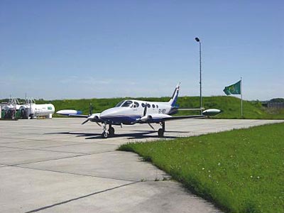
Klar zur Landung auf dem Flugplatz Bautzen bedeutet ideale Bedingungen
und ein sicheres Gefühl für alle Geschäfts- und Privatflieger.
Die 2200 x 50 m Betonpiste mit Landebahnbefeuerung ist für den Instrumenten-
und Nachtflugbetrieb ausgerüstet und entspricht damit professionellen
Anforderungen.
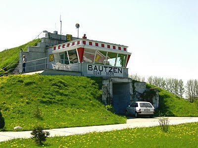
Die Entwicklung zum modernen Verkehrslandeplatz ist Bestandteil des sächsischen
Landesverkehrsplanes. Für Luftfahrzeuge bis 14 t und mehr Abfluggewicht
bietet der Flugplatz Bautzen im ostsächsischen Raum die beste Alternative
zu Dresden. Die schnelle, unkomplizierte Grenz- und Zollabfertigung bei
Flügen von und nach Polen oder Tschechien ist von großem Vorteil.
Direkte Anbindung an die Autobahn A 4 und drei Bundesstraßen ermöglichen
Zeitgewinn und kurze Wege.
Hier landen heißt deshalb:
- nur 7 Fahrtminuten bis ins Stadtzentrum Bautzen mit dem Flugplatz
Linienbus (Linie 199)
- 25 Minuten bis Löbau
- 35 Minuten bis Bischofswerda
- 35 Minuten bis Dresden
- 35 Minuten bis Görlitz/Polen
- 45 Minuten bis Niesky
- 55 Minuten bis Zittau/Tschechien
 ICAO Code EDAB
Name BAUTZEN
Land Deutschland
Bundesland Sachsen
Letzte Änderung 30. April 2003
Kategorie Verkehrslandeplatz / Public Airfield
Betreiber / Operator Flugplatz Bautzen Betreibergesellschaft mbH
ZIP / City D-02627 Purschwitz
Fon +49 (0)3591 / 601322
Fax 604961
Lage / Location 2.7 NM E Bautzen
Nachtflug / NVFR NVFR
Instrumentenflug / IFR IFR
Helicopter Ja / Yes
Motorsegler / GLDP Ja / Yes
Segelflugzeuge / GLD Ja / Yes
Ballone Ja / Yes
UL Ja / Yes
Fallschirmspringen / PJE Ja / Yes
PCN 44/R/B/W/T Luftschiffe/Airships, H-GLD, P-GLD, Flugmodelle/Flying
models
Summer 0600-1800, PPR 0400-0600, 1800-2000, SAT, SUN, HOL 0700-1800, PPR
0400-0700 + 1800-2000
Winter 0700-SS, PPR 0500-0700, SS-2100, SAT, SUN, HOL 0800-SS, PPR 0500-0800
+ SS-2100
Einschränkungen siehe AIP AD 1-6 / restrictions see AIP AD 1-6
Luftaufsicht / OPS +49 (0)3591 / 601322, Fax 604961,
AIS EDDF +49 (0)69 / 78072500
MET (0190) 077226
Gafor 26
Zoll / Customs O/R 3HR vorher/before
Fuel 100 LL, Jet A1
Oil D 100
Hangar Überdachte Fläche / Roofed area
Höhe / Elevation 568 ft / 173 m
FIS Berlin Information 126.350
VDF / QDM 129.150
Rufzeichen / Call sign Bautzen Info
Frequenz Tower 129.15 GE/EN
NAV Aids VDF/QDM - ABN 254°/0.5 NM BA 359 018°/17 NM from HDO
115.00/Ch 97 141°/61 NM from KLF115.15 071°/36 NM from DRN 115.35
Koordinaten 51 11, 61 N / 14 31, 18 E
Platzrunde / Traffic circuit N 1300
Landebahnen / RWY 2
RWY 2200 x 50 m, Concrete
RWY 07 TKOF 2200 m; LDG 2200 m
RWY 25 TKOF 2200 m; LDG 2200 m
MTOW PCN 44 R/B/W/T
RWY II 1000 x 40 m, Gras
RWY 07 TKOF 1000 m; LDG 1000 m
RWY 25 TKOF 1000 m; LDG 1000 m
MTOW RWY II 5700 kg
Bemerkungen / Remarks GLD + PJE! Wohngebiete meiden! Intensiver HEL-Betrieb
(BGS)
Address:
Flugplatz Bautzen
Betreibergesellschaft mbH
02627 Kubschütz
Tel.: 03591 601322
Fax: 03591 604961
E-mail: info at flugplatz-bautzen
de
WWW: http://www.flugplatz-bautzen.de/
Images and information placed above are from
http://www.flugplatz-bautzen.de/
http://www.airports.de/airport.php?ICAO=EDAB
We thank them for the data!
| General Info
|
| Country |
Germany
|
| ICAO ID |
EDAB
|
| Time |
UTC+1(+2DT)
|
| Latitude |
51.193531
51° 11' 36.71" N
|
| Longitude |
14.519747
014° 31' 11.09" E
|
| Elevation |
568 feet
173 meters
|
| Magnetic Variation |
002° E (01/05)
|
| Beacon |
Yes
|
| Operating Agency |
CIVIL GOVERNMENT, (LANDING FEES AND DIPLOMATIC CLEARANCE MAY BE REQUIRED)
|
| Operating Hours |
SEE REMARKS FOR OPERATING HOURS OR COMMUNICATIONS FOR POSSIBLE HOURS
|
| Daylight Savings Time |
Last Sunday in March to last Sunday in October
|
| Communications
|
| INFO |
129.15
|
| BERLIN INFO |
125.8
|
| Runways
|
ID
|
Dimensions |
Surface |
PCN |
ILS
|
| 07/25 |
7218 x 164 feet
2200 x 50 meters |
CONCRETE. |
044RBWT |
NO
|
| 07L/25R |
3281 x 131 feet
1000 x 40 meters |
GRASS OR EARTH NOT GRADED OR ROLLED. |
- |
NO
|
| Navaids
|
| Type |
ID |
Name |
Channel |
Freq |
Distance From Field |
Bearing From Navaid
|
| NDB |
BA |
BAUTZEN |
- |
359 |
1.1 NM |
251.2
|
| Supplies/Equipment
|
| Fuel |
Jet A1, without icing nhibitor.
100/130 MIL Spec, low lead, aviation gasoline (BLUE)
|
| Oil |
Available (Types unknown)
|
| Remarks
|
| CAUTION |
Extv PJE act.
|
| CSTMS/IMG |
Avbl O/R 3 hr before arr.
|
| FUEL |
(NC-100LL, A1)
|
| NS ABTMT |
Before 0600Z++, btn 1200-1400Z++, aft SS Mon-Fri. Before 0800Z++ and aft 1200Z++Sat, Sun, hol.
|
| OPR HOURS |
Opr 0700Z-SS Mon-Fri; 0800Z Sat, Sun and hol. (0600-1800Z Mon-Fri; 0700-1800Z Sat, Sun and hol DT). OT PPR.
|
| RSTD |
No flt trng in tfc pat 1100-0700Z++, Sun or hol.
|
Runway 07/25
7218 x 164 feet
2200 x 50 meters
| Runway 07
|
| Surface |
CONCRETE.
|
| True Heading |
073.0
|
| Latitude |
51.190675
51° 11' 26.43" N
|
| Longitude |
14.504683
014° 30' 16.86" E
|
| Elevation |
568.0 feet
173 meters
|
| Slope |
-0.5°
|
| Landing Distance |
7218 feet
2200 meters
|
| Takeoff Distance |
7218 feet
2200 meters
|
| Lighting System |
HIRL
|
| Runway 25
|
| Surface |
CONCRETE.
|
| True Heading |
253.0
|
| Latitude |
51.196381
51° 11' 46.97" N
|
| Longitude |
14.534814
014° 32' 05.33" E
|
| Elevation |
530.0 feet
162 meters
|
| Slope |
0.5°
|
| Landing Distance |
7218 feet
2200 meters
|
| Takeoff Distance |
7218 feet
2200 meters
|
| Lighting System |
HIRL
BO |
Runway 07L/25R
3281 x 131 feet
1000 x 40 meters
| Runway 07L
|
| Surface |
GRASS OR EARTH NOT GRADED OR ROLLED.
|
| True Heading |
073.3
|
| Latitude |
51.191853
51° 11' 30.67" N
|
| Longitude |
14.505906
014° 30' 21.26" E
|
| Landing Distance |
3281 feet
1000 meters
|
| Takeoff Distance |
3281 feet
1000 meters
|
| Runway 25R
|
| Surface |
GRASS OR EARTH NOT GRADED OR ROLLED.
|
| True Heading |
253.3
|
| Latitude |
51.194472
51° 11' 40.10" N
|
| Longitude |
14.519586
014° 31' 10.51" E
|
| Landing Distance |
3281 feet
1000 meters
|
| Takeoff Distance |
3281 feet
1000 meters
|
Navaids
| BAUTZEN
|
| Type |
ID |
Channel |
Freq |
Country |
State
|
| NDB |
BA |
- |
359 |
Germany |
-
|
| Latitude |
Longitude |
Airport
|
51.198814
51° 11' 55.73" N |
14.547831
014° 32' 52.19" E |
EDAB |
The content above was published at Airports-Worldwide.com in 2005.
We don't guarantee the information is fresh and accurate. The data may be wrong or outdated.
For more up-to-date information please refer to other sources.
|


