|
ICAO Code ETEJ
Name BAMBERG
Land Deutschland
Bundesland Bayern
Letzte Änderung 18. März 2005
Kategorie Sonderlandeplatz / Special Airfield
Betreiber / Operator Militär
Internet - Yes
LFZ / ACFT Bis / up to 5700 kg
Helicopter Ja / Yes
Summer PPR
Winter PPR
O/T PPR
PPR +49 (0)951 / 45145, 01728603493, 01714061527, 01728630490
AIS EDDF +49 (0)69 / 695960-0
MET (0190) 077225
Gafor 54
Zoll / Customs Nein / No
Fuel 100 LL, Mogas, Jet A1
Oil Nein / No
Hangar Nein / No
Höhe / Elevation 821 ft / 255 m
Rufzeichen / Call sign Bamberg Info
Frequenz Tower 120.175 GE
Koordinaten 49 55,2 N / 10 54,9 E
Landebahnen / RWY 1
RWY 1290 x 15 m, ASPHALT
RWY 04 TKOF 1150 m; LDG 1150 m
RWY 22 TKOF 1052 m; LDG 1045 m
MTOW 5700 kg
Bemerkungen / Remarks Mil ACFT
Restaurant - No
 Postal Address:
Flugpl. Bamberg-Breitenau,
Postfach 1006,
D-96001 Bamberg
Office Address:
Zeppelinstr. 18,
D-96052 Bamberg
Telephon: Tower: +49-951-45145
Telefax: +49-9544-9835948
E-mail: eMail at Aeroclub-Bamberg
de
WWW: http://www.aeroclub-bamberg.de/
Images and information placed above are from
http://www.aeroclub-bamberg.de/
http://www.airports.de/airport.php?ICAO=ETEJ
We thank them for the data!
| General Info
|
| Country |
Germany
|
| ICAO ID |
ETEJ
|
| Time |
UTC+1(+2DT)
|
| Latitude |
49.920433
49° 55' 13.56" N
|
| Longitude |
10.914233
010° 54' 51.24" E
|
| Elevation |
823 feet
251 meters
|
| Magnetic Variation |
001° E (01/05)
|
| Beacon |
Yes
|
| Operating Agency |
U.S.ARMY
|
| Alternate Name |
BAMBERG BREITENAU
|
| Operating Hours |
SEE REMARKS FOR OPERATING HOURS OR COMMUNICATIONS FOR POSSIBLE HOURS
|
| Daylight Savings Time |
Last Sunday in March to last Sunday in October
|
| Communications
|
INFO
(For use entering tfc, wkend only)
|
120.175
|
| AIR GND RDO |
37.4
|
| Runways
|
ID
|
Dimensions |
Surface |
PCN |
ILS
|
| 04/22 |
3773 x 50 feet
1150 x 15 meters |
ASPHALT |
018FDWT |
NO
|
| Remarks
|
| CAUTION |
Unmrk wires 150' AGL, 1000' fr apch end Rwy 22. Extv gldr and civ flt on wkends and GM hol with ocnl gldr and civ flt occurring dur nml duty hr.
|
| LGT |
24 hr PPR for rwy lgt on aft duty hr and wkend.
|
| NS ABTMT |
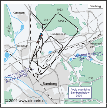
No ovft city of Gartenstadt 0.5 NM SE. No ovft Reese rng 2 NM SE. No ovft of town of Stegaurach 4 NM SW. Avoid ovft of all built up areas vcnty of arpt. No ovftof town of Lichteneiche 0.5 NM NE.
|
| OPR HOURS |
Unattended, Range Ctl hr 0700-1500Z++.
|
| RSTD |
PPR, ctc 279th BSB Range Ctl at DSN 469-7411/7719 or fax DSN 469-8747. Acft may not shutdown on VIP pad. Tran acft and all UH-60 or larger acft prk S of VIP padalong yellow tires. Arpt clsd to USA F/W acft.
|
| TFC PAT |
NW 1800'.
|
Runway 04/22
3773 x 50 feet
1150 x 15 meters
| Runway 04
|
| Surface |
ASPHALT
|
| True Heading |
036.0
|
| Latitude |
49.916667
49° 55' 00.00" N
|
| Longitude |
10.910000
010° 54' 36.00" E
|
| Landing Distance |
3230 feet
985 meters
|
| Takeoff Distance |
4324 feet
1318 meters
|
| Displaced Threshold Length |
543 feet
166 meters
|
| Overrun Length |
551 feet
168 meters
|
| Overrun Surface |
ASPHALT
|
| Lighting System |
LIRL
|
| Runway 22
|
| Surface |
ASPHALT
|
| True Heading |
216.0
|
| Latitude |
49.925000
49° 55' 30.00" N
|
| Longitude |
10.919500
010° 55' 10.20" E
|
| Landing Distance |
3175 feet
968 meters
|
| Takeoff Distance |
4364 feet
1330 meters
|
| Displaced Threshold Length |
598 feet
182 meters
|
| Overrun Length |
591 feet
180 meters
|
| Overrun Surface |
ASPHALT
|
| Lighting System |
LIRL
|
The content above was published at Airports-Worldwide.com in 2005.
We don't guarantee the information is fresh and accurate. The data may be wrong or outdated.
For more up-to-date information please refer to other sources.
|


