 |
|
 ICAO Code EDMA
IATA Code AGB
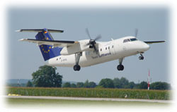
Name AUGSBURG
Land Deutschland
Bundesland Bayern
Letzte Änderung 17. März 2005
Kategorie Verkehrslandeplatz / Public Airfield
Betreiber / Operator Augsburger Flughafen GmbH
Adresse Flughafenstr.
ZIP / City D-86169 Augsburg
Fax 821 / 741844
Internet - Yes
Lage / Location 3.5 NM NE Augsburg
Nachtflug / NVFR NVFR PPR
Instrumentenflug / IFR IFR
LFZ / ACFT Bis / up to PCN 50
Helicopter Ja / Yes
Motorsegler / GLDP Ja / Yes
Segelflugzeuge / GLD Ja / Yes
Fallschirmspringen / PJE Ja / Yes
Luftschiffe/Airships
Summer MON-Fri 0400-1900, PPR 0400-0800 and 1700-2000, Sat 0700-1700,
Sun, HOL 0700-2000, PPR 0700-0800 and 1700-2000, CTR Mon-Sun 0400-2000
Winter MON-Fri 0500-2000, PPR 0500-0900 and 1800-2100, Sat 0800-1800,
Sun/HOL 0800-2100, PPR 0800-0900 and 1800-2100, CTR Mon-Sun 0500-2100
O/T PPR
Einschränkungen siehe AIP AD 1-6/ restrictions see chart section
and AD 1-6
Luftaufsicht / OPS +49 (0)821 / 2708134, Fax 2708119, 2708139
AIS AIS-Centre EDDZ+49 (0)69 / 78072500
ACC EDDM +49 (0)89 / 9785317
MET (0190) 077225
Gafor 72
Zoll / Customs Ja/yes
Fuel 100 LL Jet A1
Oil 80, 100 D 80, D 100, Multigrade SAE 20W-50
Hangar Ja / Yes
Höhe / Elevation 1515 ft / 462 m
FIS München Information 126.950
VDF / QDM 124.975
Rufzeichen / Call sign Augwsburg TOWER/TURM
Frequenz Tower 124.975 EN/GE
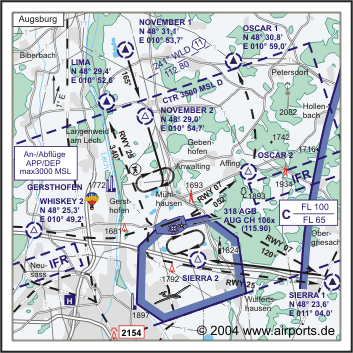
NAV Aids AGB 318 und AUG DME 115.90 am Platz/ at field - 248°/11 NM
from WLD 112.80, PAPI 07
Koordinaten 48 25, 51 N / 10 55, 91 E
Landebahnen / RWY 1
RWY 1280 x 30 m, ASPHALT
RWY 07 TKOF 1280 m; LDG 1280 m
RWY 25 TKOF 1280 m; LDG 1280 m
MTOW LCN 50
Bemerkungen / Remarks TWR*/CTR: 0500-2100 (0400-2000)! Lech in der Platzrunde
nicht überfliegen! Hochspannungsleitung / High tension lines E of
RWY! GLD + PJE! Wohngebiete meiden! VFR- Nachtflüge PPR!
Restaurant - Yes
E-mail: flughafen at augsburg-airport de
WW: http://www.augsburg-airport.de/
Images and information placed above are from
http://www.augsburg-airport.de/
http://www.airports.de/airport.php?ICAO=EDMA
We thank them for the data!
| General Info
|
| Country |
Germany
|
| ICAO ID |
EDMA
|
| Time |
UTC+1(+2DT)
|
| Latitude |
48.425158
48° 25' 30.57" N
|
| Longitude |
10.931764
010° 55' 54.35" E
|
| Elevation |
1515 feet
462 meters
|
| Type |
Civil
|
| Magnetic Variation |
001° E (01/05)
|
| Beacon |
Yes
|
| Operating Agency |
CIVIL GOVERNMENT, (LANDING FEES AND DIPLOMATIC CLEARANCE MAY BE REQUIRED)
|
| Operating Hours |
SEE REMARKS FOR OPERATING HOURS OR COMMUNICATIONS FOR POSSIBLE HOURS
|
| Daylight Savings Time |
Last Sunday in March to last Sunday in October
|
| Communications
|
TWR
Opr 0500-2000Z++ Mon-Sat, 0800-2000Z++ Sun and hol.
|
124.975
338.975
|
| MUNCHEN RADAR |
128.25
279.6
|
| MUNCHEN INFO |
120.65
126.95
|
ATIS
Opr 0500-2100Z++ Mon-Sun.
|
124.575
|
| Runways
|
ID
|
Dimensions |
Surface |
PCN |
ILS
|
| 07/25 |
4199 x 98 feet
1280 x 30 meters |
ASPHALT |
050FCZU |
YES
|
| 07L/25R |
3325 x 100 feet
1013 x 30 meters |
GRASS OR EARTH NOT GRADED OR ROLLED. |
- |
NO
|
| Navaids
|
| Type |
ID |
Name |
Channel |
Freq |
Distance From Field |
Bearing From Navaid
|
| NDB |
AGB |
AUGSBURG |
- |
318 |
At Field |
-
|
| DME |
AUG |
AUGSBURG |
106X |
- |
At Field |
-
|
| Supplies/Equipment
|
| Fuel |
Jet A1+, Jet A1 with icing inhibitor.
100/130 MIL Spec, low lead, aviation gasoline (BLUE)
|
| Oil |
O-117, 1100, Reciprocating Engine Oil (MIL L 6082)
O-123, 1065,(Dispersant)Reciprocating Engine Oil(MIL L 22851 Type III)
|
| Remarks
|
| CAUTION |
Ints lgt F/W acft trng in vcnty. Obst 1730' MSL, 6532' thld Rwy 25. Pilot responsible for maneuvers on apron, mnt twr freq.
|
| CSTMS/AG/IMG |
CSTMS - PAX wo merchandise only.
|
| FUEL |
(NC-100LL, A1)
|
| LGT |
PAPI Rwy 07 GS 3.3 , PAPI Rwy 25 GS 3.5 MEHT 48'.
|
| NS ABTMT |
Before 0600Z++, btn 1200-1400Z++, aft SS Mon-Fri. Before 0800Z++ and aft 1200Z++Sat, Sun, hol.
|
| OIL |
O-117-123
|
| OPR HOURS |
Opr 0600-2000Z++ Mon-Sat, 0800-2000Z++ Sun and hol. 0500-0600Z++ Mon-Sat, 2000-2100 Sun and hol PPR, Fone C+49(0)8212 7081 34 fax 19.
|
| RSTD |
NORDO proh. Estab ctc 5 min prior to compul REP. Const rwy 07/25 ASDA extn, PAPIrwy 07 disp.
|
Runway 07/25
4199 x 98 feet
1280 x 30 meters
| Runway 07
|
| Surface |
ASPHALT
|
| True Heading |
071.0
|
| Latitude |
48.423386
48° 25' 24.19" N
|
| Longitude |
10.923550
010° 55' 24.78" E
|
| Elevation |
1510.0 feet
460 meters
|
| Slope |
0.1°
|
| Landing Distance |
4199 feet
1280 meters
|
| Takeoff Distance |
4759 feet
1451 meters
|
| Overrun Length |
560 feet
171 meters
|
| Overrun Surface |
ASPHALT
|
| Lighting System |
SF
HIRL
REIL
T
PAPI |
| Runway 25
|
| Surface |
ASPHALT
|
| True Heading |
251.0
|
| Latitude |
48.427047
48° 25' 37.37" N
|
| Longitude |
10.939931
010° 56' 23.75" E
|
| Elevation |
1515.0 feet
462 meters
|
| Slope |
-0.1°
|
| Landing Distance |
4199 feet
1280 meters
|
| Takeoff Distance |
4669 feet
1423 meters
|
| Overrun Length |
470 feet
143 meters
|
| Overrun Surface |
ASPHALT
|
| Lighting System |
SF
HIRL
REIL
T
PAPI |
Runway 07L/25R
3325 x 100 feet
1013 x 30 meters
| Runway 07L
|
| Surface |
GRASS OR EARTH NOT GRADED OR ROLLED.
|
| True Heading |
071.5
|
| Latitude |
48.421828
48° 25' 18.58" N
|
| Longitude |
10.930314
010° 55' 49.13" E
|
| Landing Distance |
3325 feet
1013 meters
|
| Takeoff Distance |
3325 feet
1013 meters
|
| Runway 25R
|
| Surface |
GRASS OR EARTH NOT GRADED OR ROLLED.
|
| True Heading |
251.5
|
| Latitude |
48.424719
48° 25' 28.99" N
|
| Longitude |
10.943314
010° 56' 35.93" E
|
| Landing Distance |
3325 feet
1013 meters
|
| Takeoff Distance |
3325 feet
1013 meters
|
Navaids
| AUGSBURG
|
| Type |
ID |
Channel |
Freq |
Country |
State
|
| NDB |
AGB |
- |
318 |
Germany |
-
|
| Latitude |
Longitude |
Airport
|
48.424297
48° 25' 27.47" N |
10.933094
010° 55' 59.14" E |
EDMA |
Navaids
| AUGSBURG
|
| Type |
ID |
Channel |
Freq |
Country |
State
|
| DME |
AUG |
106X |
- |
Germany |
-
|
| Latitude |
Longitude |
Airport
|
48.424283
48° 25' 27.42" N |
10.932958
010° 55' 58.65" E |
EDMA |
The content above was published at Airports-Worldwide.com in 2005.
We don't guarantee the information is fresh and accurate. The data may be wrong or outdated.
For more up-to-date information please refer to other sources.
|
|


