|
 |
|
||||
|
By
Wikipedia,
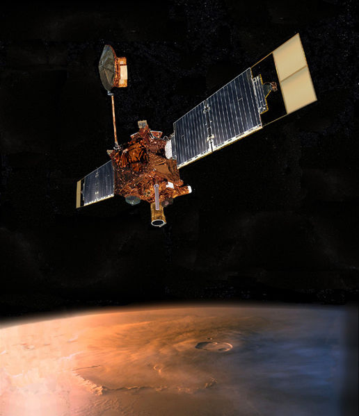
The Mars Global Surveyor (MGS) was a US spacecraft developed by NASA's Jet Propulsion Laboratory and launched November 1996. It began the United States's return to Mars after a 10-year absence. It completed its primary mission in January 2001 and was in its third extended mission phase when, on November 2, 2006, the spacecraft failed to respond to messages and commands. A faint signal was detected three days later which indicated that the craft had gone into safe mode. All attempts to recontact the Mars Global Surveyor and resolve the problem failed. In January 2007 NASA officially ended the mission. SpecificationsThe Surveyor spacecraft, fabricated at the Lockheed Martin Astronautics plant in Denver, is a rectangular-shaped box with wing-like projections (solar panels, used to convert sunlight into electricity) extending from opposite sides. When fully loaded with propellant at the time of launch, the spacecraft weighed 1,060 kg (2,337 lb). Most of Surveyor's mass lies in the box-shaped module occupying the center portion of the spacecraft. This center module is made of two smaller rectangular modules stacked on top of each other, one of which is called the equipment module and holds the spacecraft's electronics, science instruments, and the 1750A mission computer. The other module, called the propulsion module, houses Surveyor's rocket engines and propellant tanks. Scientific instrumentsFive scientific instruments fly onboard Mars Global Surveyor:
The Mars Orbiter Camera (MOC) science investigation used 3 instruments: a narrow angle camera that took (black-and-white) high resolution images (usually 1.5 to 12 m per pixel) and red and blue wide angle pictures for context (240 m per pixel) and daily global imaging (7.5 km per pixel). MOC returned more than 240,000 images spanning portions of 4.8 Martian years, from September 1997 and November 2006. A high resolution image from MOC is either 1.5 or 3.1 Km wide. So any image from this camera is at most 3.1 Km wide. Often, a picture will be smaller than this because it has been cut to just show a certain feature. These high resolution images may be 3 to 10 Km long. When a high resolution image is taken, a context image is taken as well. The context image shows the image footprint of the high resolution picture. Context images are typically 115.2 Km square with 240 m/pixel resolution. Launch and orbit insertionThe Surveyor spacecraft was launched from the Cape Canaveral Air Station in Florida on November 7, 1996 aboard a Delta II rocket. The spacecraft traveled nearly 750 million kilometers (466 million miles) over the course of a 300-day cruise to reach Mars on September 11, 1997. Upon reaching Mars, Surveyor fired its main rocket engine for the 22-minute Mars orbit insertion (MOI) burn. This maneuver slowed the spacecraft and allowed the planet's gravity to capture it into orbit. Initially, Surveyor entered a highly elliptical orbit that took 45 hours to complete. The orbit had a periapsis of 262 km (163 mi) above the northern hemisphere, and an apoapsis of 54,026 km (33,570 mi) above the southern hemisphere. AerobrakingAfter orbit insertion, Surveyor performed a series of orbit changes to lower the periapsis of its orbit into the upper fringes of the Martian atmosphere at an altitude of about 110 km (68 mi). During every atmospheric pass, the spacecraft slowed down by a slight amount because of atmospheric resistance. The density of the Martian atmosphere at such altitudes is comparatively low, allowing this procedure to be performed without damage to the spacecraft. This slowing caused the spacecraft to lose altitude on its next pass through the orbit's apoapsis. Surveyor used this aerobraking technique over a period of four months to lower the high point of its orbit from 54,000 km (33,554 mi) to altitudes near 450 km (280 mi). On October 11, the flight team performed a maneuver to raise the periapsis out of the atmosphere. This suspension of aerobraking was performed because air pressure from the atmosphere caused one of Surveyor's two solar panels to bend backward by a slight amount. The panel in question was slightly damaged shortly after launch in November 1996. Aerobraking was resumed on November 7 after flight team members concluded that aerobraking was safe, provided that it occurs at a more gentle pace than proposed by the original mission plan.
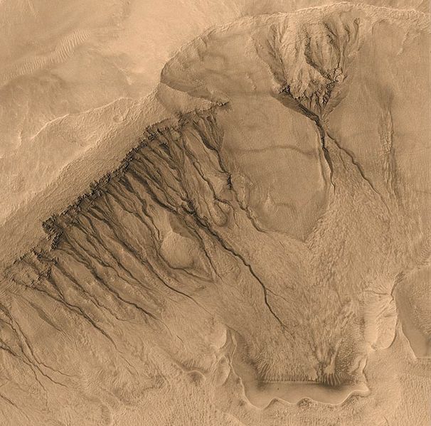
Under the new mission plan, aerobraking occurred with the low point of the orbit at an average altitude of 120 km (75 mi), as opposed to the original altitude of 110 km (68 mi). This slightly higher altitude resulted in a decrease of 66 percent in terms of air resistance pressure experienced by the spacecraft. During these six months, aerobraking reduced the orbit period to between 12 and 6 hours. From May to November 1998, aerobraking was temporarily suspended to allow the orbit to drift into the proper position with respect to the Sun. Without this hiatus, 'Surveyor' would complete aerobraking with its orbit in the wrong solar orientation. In order to maximize the efficiency of the mission, these six months were devoted to collecting as much science data as possible. Data was collected between two to four times per day, at the low point of each orbit. Finally, from November 1998 to March 1999, aerobraking continued and shrank the high point of the orbit down to 450 km (280 mi). At this altitude, Surveyor circled Mars once every two hours. Aerobraking was scheduled to terminate at the same time the orbit drifted into its proper position with respect to the Sun. In the desired orientation for mapping operations, the spacecraft always crossed the day-side equator at 14:00 (local Mars time) moving from south to north. This geometry was selected to enhance the total quality of the science return. MappingThe spacecraft circled Mars once every 117.65 minutes at an average altitude of 378 kilometers (235 miles). It is in a near polar orbit (inclination = 93°) which is almost perfectly circular, moving from being over the south pole to being over the north pole in just under an hour. The altitude was chosen to make the orbit sun-synchronous, so that all images that were taken by the spacecraft of the same surface features on different dates were taken under identical lighting conditions. After each orbit, the spacecraft viewed the planet 28.62° to the west because Mars had rotated underneath it. In effect, it was always 14:00 for Mars Global Surveyor as it moved from one time zone to the next exactly as fast as the Sun. After seven sols and 88 orbits, the spacecraft would approximately retrace its previous path, with an offset of 59 km to the east. This ensured eventual full coverage of the entire surface. In its extended mission, MGS did much more than study the planet directly beneath it. It commonly performed rolls and pitches to acquire images off of its nadir track. The roll maneuvers, called ROTOs (Roll Only Targeting Opportunities), rolled the spacecraft left or right from its ground track to shoot images as much as 30° from nadir. It was possible for a pitch maneuver to be added to compensate for the relative motion between the spacecraft and the planet. This was called a CPROTO (Compensation Pitch Roll Targeting Opportunity), and allowed for some very high resolution imaging by the on board MOC (Mars Orbiting Camera). In addition to this, MGS could shoot pictures of other orbiting bodies, such as other spacecraft and the moons of Mars. MER communications subsystemMars Global Surveyor functioned as a communications satellite relaying data back to Earth from the MER surface landers. Portions of MGS had been scheduled to remain active until at least September 2008 to support MER. Loss of contactOn November 2, 2006, NASA lost contact with the spacecraft after commanding it to adjust its solar panels. Several days later a faint signal was received indicating that the spacecraft had entered safe mode, and was awaiting further instructions from Earth. On November 20, the Mars Reconnaissance Orbiter spacecraft attempted to take a picture of Mars Global Surveyor in order to check the craft's orientation towards the Sun and Earth to help diagnose the problem. The effort was unsuccessful. On November 21–November 22 MGS failed to relay communications to the Opportunity rover on the surface of Mars. After this failed effort, Mars Exploration Program manager Fuk Li said, "Realistically, we have run through the most likely possibilities for re-establishing communication, and we are facing the likelihood that the amazing flow of scientific observations from Mars Global Surveyor is over." On January 10, 2007, NASA announced that the loss of the spacecraft might have been caused by a flaw in a parameter update to the spacecraft's system in June, 2006. In this update, two memory addresses were incorrect. Consequently the solar arrays were driven until a hard stop and the spacecraft subsequently went into safe mode. One of the consequences of the parameter flaw was that the spacecraft incorrectly diagnosed a failure of a gimbal motor. In special logic built into MGS' flight software, this meant that the spacecraft was rotated to point the "stuck" solar array at the Sun. But in this geometry, the radiator that should cool down the spacecraft's last surviving battery was also pointed at the sun, resulting in an overheating of (and subsequent failure of) the battery. NASA said this scenario should be treated as preliminary. But ultimately, the fate of the spacecraft may never be known for certain. On April 13, 2007, NASA reported that the likely cause of the spacecraft's demise was "battery failure caused by a complex sequence of events involving the onboard computer memory and ground commands." Originally, the spacecraft was to observe Mars for 1 Mars year, roughly 2 Earth years. Based on the valuable science data, the National Aeronautics and Space Administration extended its mission three times. MGS and general relativity: the Lense-Thirring testData from MGS have also been used to perform a test of the general relativistic Lense-Thirring effect which consists of a small precession of the orbital plane of a test particle moving around a central, rotating mass like, e.g., a planet. The interpretation of the out-of-plane Root-Mean-Square (RMS) time series of MGS in terms of such a relativistic feature of motion by L. Iorio was criticized by K. Krogh; however, L. Iorio supported his thesis with new arguments. Discovery of water on MarsOn December 6, 2006 NASA released photos of two craters called Terra Sirenum and Centauri Montes which appear to show the presence of water on Mars at some point between 1999 and 2001. The pictures were produced by the Mars Global Surveyor and are quite possibly the spacecraft's final contribution to our knowledge of Mars and the question of whether life or water exists on the planet. Mission timeline
Other picturesSee alsoExternal links
Text from Wikipedia is available under the Creative Commons Attribution/Share-Alike License; additional terms may apply.
Published in July 2009. Click here to read more articles related to aviation and space!
|
||||||||||||||||||||||||||||||||||||||||||||||||||||||||||||||||||||||

 |
|
Copyright 2004-2026 © by Airports-Worldwide.com, Vyshenskoho st. 36, Lviv 79010, Ukraine Legal Disclaimer |