|
 |
|
||||
|
By
Wikipedia,
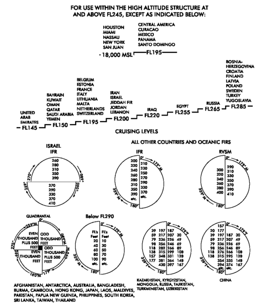
A Flight Level (FL) is a standard nominal altitude of an aircraft, in hundreds of feet. This altitude is calculated from a world-wide fixed pressure datum of 1013.25 hPa (29.921 inHg), the average sea-level pressure, and therefore is not necessarily the same as the aircraft's true altitude either above mean sea level or above ground level. BackgroundHistorically, altitude has been measured using a pressure altimeter, which is essentially a calibrated barometer. An altimeter measures air pressure, which decreases with increasing altitude, and from the pressure calculates and displays the corresponding altitude. To display altitude above sea level, a pilot must recalibrate the altimeter according to the local air pressure at sea level, to take into account natural variation of pressure over time and in different regions. If this is not done, two aircraft could be flying at the same altitude even though their altimeters appear to show that they are at considerably different altitudes. This is a critical safety issue. Flight levels solve this problem by defining altitudes based on a standard pressure. All aircraft operating on flight levels calibrate to this setting regardless of the actual sea level pressure. Flight levels are described by a number, which is this nominal altitude ("pressure altitude") in feet, divided by 100. Therefore an apparent altitude of, for example, 32,000 feet is referred to as "flight level 320". To avoid collisions between two aircraft due to their being at the same altitude, their 'real' altitudes (compared to ground level, for example) are not important; it is the difference in altitudes that determines whether they might collide. This difference can be determined from the air pressure at each craft, and does not require knowledge of the local air pressure on the ground. Flight levels are usually designated in writing as FLxxx, where xxx is a one- to three-digit number indicating the pressure altitude in units of 100 feet. In radio communications, FL290 would be pronounced as "flight level two niner zero", in most jurisdictions. The phrase "flight level" makes it clear that this refers to the standardized pressure altitude. Transition altitudeWhilst use of a standardised pressure setting facilitates separation of aircraft from each other, it does not provide the aircraft's actual height above ground. At low altitudes the true height of an aircraft relative to an object on the ground needs to be known. The pressure setting to achieve this is called QNH or "altimeter setting" and is available from various sources, including air traffic control and the local METAR-issuing station. The transition altitude (TA) is the height at which aircraft change from the use of altitude to the use of flight levels. When operating at or below the TA, aircraft altimeters are usually set to show the altitude above sea level. Above the TA, the aircraft altimeter pressure setting is normally adjusted to the standard pressure setting of 1013.25 hectopascals (millibars) or 29.92 inches of mercury and aircraft altitude will be expressed as a flight level.
In the USA and Canada, the transition altitude is 18,000ft. In Europe, the transition altitude varies and can be as low as 3,000ft. There are discussions to standardise the transition altitude within the Eurocontrol area. On 25 November 2004 the Civil Aviation Authority of New Zealand raised New Zealand's transition altitude from 11 000 feet to 13 000 feet and changing the transition level from flight level 130 to flight level 150. The transition level is the lowest flight level above the transition altitude. The table on the right shows the transition level according to transition altitude and QNH. When descending below the transition level, the pilot starts to refer to altitude of the aircraft by setting the altimeter to the QNH for the region or airfield. Note that the transition level is, by definition, less than 500ft above the transition altitude. Aircraft are not normally assigned to fly at the transition level as this does not guarantee separation from other traffic flying (on QNH) at the transition altitude; the lowest usable flight level is the transition level plus 500 feet. The transition layer is the airspace between the transition altitude and the transition level. Quadrantal rule(This rule applies to IFR flights in the UK outside controlled airspace and is advised for VFR flights above 3,000 ft AMSL outside controlled airspace; few other countries adopt this rule) Flight levels are 500 ft apart, but to further ensure the separation of aircraft, aircraft travelling in different directions in level flight (i.e. not climbing or descending) below FL 245 (24,500 ft) are required to adopt flight levels according to the quadrantal rule, as follows:
Semicircular/Hemispheric rule((Versions of this apply to IFR in the UK inside controlled airspace and generally in the rest of the world)), The semicircular rule (also known as the hemispheric rule) applies, in slightly different version, in all of the world, including in the UK inside controlled airspace. The standard rule define an East/West track split:
At FL 290 and above, if Reduced Vertical Separation Minima are not in use, 4,000 ft intervals are used to separate same-direction aircraft (instead of 2,000 ft intervals below FL 290), and only odd flight levels are assigned, depending on the direction of flight:
Countries where the major airways are oriented north/south (e.g. New Zealand; Italy; Portugal) have semicircular rules that define a North/South rather than an East/West track split. In Italy, for example, southbound traffic uses odd flight levels. Reduced Vertical Separation Minima(In the U.S. and Canada, the foregoing information applies to flights under instrument flight rules (IFR). Different altitudes will apply for aircraft flying under visual flight rules (VFR) above 3000 ft AGL.) Reduced Vertical Separation Minima or RVSM reduces the vertical separation above FL 290 from 2,000 ft to 1,000 ft. This allows aircraft to safely fly more optimum routes, gain fuel savings and increase airspace capacity by adding six new flight levels. Only aircraft that have been certified to meet RVSM standards, with several exclusions, are allowed to fly in RVSM airspace. RVSM went into effect in Europe between FL 290 and FL 410 on the 24th of January, 2002. The United States, Canada and Mexico transitioned to RVSM between FL 290 and FL 410 on the 20th of January, 2005, and Africa on the 25th of September, 2008.
At FL 410 and above, 4,000 ft intervals are resumed to separate same-direction aircraft and only odd Flight Levels are assigned, depending on the direction of flight:
Metric flight levelsChina, Mongolia, Russia and many CIS countries use flight levels specified in metres. Aircraft entering these areas normally make a slight climb or descent to adjust for this. The flight levels below apply to Russia, Mongolia, North Korea, Kyrgyzstan, Kazakhstan, and 6,000 m or below in Turkmenistan (where feet is used for FL210 and above). Flight levels are read as e.g. "flight level 7,500 metres": ChinaThe flight levels in China, excluding Hong Kong, Macau and Taiwan, are: See also
Text from Wikipedia is available under the Creative Commons Attribution/Share-Alike License; additional terms may apply.
Published in July 2009. Click here to read more articles related to aviation and space!
|
|||||||||||||||||||||||||||||||||||||||||||||||||||||||||||||||||||||||||||||||||

 |
|
Copyright 2004-2026 © by Airports-Worldwide.com, Vyshenskoho st. 36, Lviv 79010, Ukraine Legal Disclaimer |