 |
|
 The air field Peenemünde was built in 1936 as a
test site called "Peenemünde West" for the Luftwaffe.
The air field Peenemünde was built in 1936 as a
test site called "Peenemünde West" for the Luftwaffe.
A variety of different airplanes with rocket propulsion, takeoff assistent
rockets, guided weapons, and especially the "flying bomb" Fieseler
Fi 103 ("V1") were tested here. The world's first rocket plane,
the Heinkel He 176, was successfully tested here, and with the Messerschmitt
Me 163A a speed record of 1003 km/h was established in 1941.
After the war, the air field was used by the Soviet Union until 1958,
and then given to the NVA (GDR military), which maintained one of the
largest and most modern squadrons of the GDR, the Jagdfliegergeschwader
9, until 1990.
Today, sightseeing flights over Usedom and Rügen islands are offered
from the air field.
During the summer, round trips by bus to the historic sites of the air
field are offered.
 ICAO
Code EDCP ICAO
Code EDCP
Name PEENEMÜNDE
Land Deutschland
Bundesland Mecklenburg-Vorpommern
Letzte Änderung 11. November 2004
Kategorie Sonderlandeplatz / Special Airfield
Betreiber / Operator Usedomer Fluggesellschaft mbH
Lage / Location NW Spitze Insel Usedom/ NW top of the Usedom island
LFZ / ACFT Bis / up to 5700 kg
Helicopter Ja / Yes
Motorsegler / GLDP Ja / Yes
UL Ja / Yes
Fallschirmspringen / PJE Ja / Yes
Summer 0800-1600
Winter 0800-1600
O/T PPR
Luftaufsicht / OPS +49 (0)38371 / 20360, 28582
PPR +49 (0)700 / 33334747
AIS EDDB +49 (0)30 / 60918250
MET (0190) 077222
Gafor 12
Zoll / Customs Nein / No
Fuel 100 LL
Oil 15W50, EE 80, 100
Hangar Nein / No
Höhe / Elevation 7 ft / 2 m
FIS Berlin Information 126.350
Rufzeichen / Call sign Peenemünde Info
Frequenz Tower 122.475 EN/GE
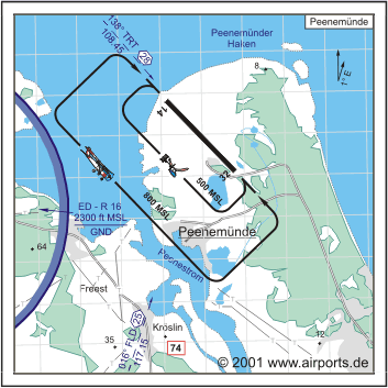
NAV Aids 138°/28 NM from TRT 108.45 016°/25 NM from FLD 117.15
Koordinaten 54 09, 47 N / 13 46, 36 E
Platzrunde / Traffic circuit SW 800
Landebahnen / RWY 1
RWY 2400 x 60 m, CONCRETE
RWY 13 TKOF 2400 m; LDG 2400 m
RWY 31 TKOF 2400 m; LDG 2400 m
MTOW 5700 kg
Bemerkungen / Remarks Wohngebiete meiden!
Restaurant Ja
Adresse
Flugplatz Peenemünde
ZIP / City D-17449 Peenemünde
Fon +49 (0)38371 / 28523
Fax 26581
Images and information placed above are from http://www.airports.de/airport.php?ICAO=EDCP
http://www.leuband.de/peen2002/en/exp08.htm
We thank them for the data!
| General Info
|
| Country |
Germany
|
| ICAO ID |
EDCP
|
| Time |
UTC+1(+2DT)
|
| Latitude |
54.157833
54° 09' 28.20" N
|
| Longitude |
13.772667
013° 46' 21.60" E
|
| Elevation |
7 feet
2 meters
|
| Magnetic Variation |
002° E (01/05)
|
| Operating Agency |
PRIVATE
|
| Daylight Savings Time |
Last Sunday in March to last Sunday in October
|
| Communications
|
| INFO |
122.475
|
| BERLIN INFO |
126.35
|
| Runways
|
ID
|
Dimensions |
Surface |
PCN |
ILS
|
| 13/31 |
7874 x 197 feet
2400 x 60 meters |
CONCRETE. |
- |
NO
|
| Remarks
|
| FUEL |
(NC-100LL)
|
| OPR HOURS |
Opr 0800-1600Z DT, OT PPR.
|
Runway 13/31
7874 x 197 feet
2400 x 60 meters
| Runway 13
|
| Surface |
CONCRETE.
|
| True Heading |
137.0
|
| Latitude |
54.165728
54° 09' 56.62" N
|
| Longitude |
13.760158
013° 45' 36.57" E
|
| Landing Distance |
7874 feet
2400 meters
|
| Takeoff Distance |
7874 feet
2400 meters
|
| Runway 31
|
| Surface |
CONCRETE.
|
| True Heading |
317.0
|
| Latitude |
54.149933
54° 08' 59.76" N
|
| Longitude |
13.785167
013° 47' 06.60" E
|
| Landing Distance |
7874 feet
2400 meters
|
| Takeoff Distance |
7989 feet
2435 meters
|
| Overrun Length |
115 feet
35 meters
|
| Overrun Surface |
GRASS OR EARTH NOT GRADED OR ROLLED.
|
The content above was published at Airports-Worldwide.com in 2005.
We don't guarantee the information is fresh and accurate. The data may be wrong or outdated.
For more up-to-date information please refer to other sources.
|
|


