 |
 |
|
||||
|
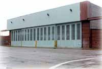
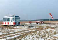
The city of Brandenburg an der Havel and the Potsdam-Mittelmark district, in conjunction with the airfield's management company, the Flugplatz Brandenburg-Briest Verwaltungs-GmbH, plan to develop the private Brandenburg-Briest landing strip into a commercial airstrip of regional significance, whereby provision has been made to reconstruct some 1.600 m of take-off and landing (additional 150 m CWY / 350 SWY each) CONC-runway , 900 m ground-strip and 900 m water-strip. The water-strip is to be provided for public use and will be the only one of its kind in Germany with a special service-area and taxiway between water-strip and airport. The same site is earmarked for the development of app. 100 ha commercial and industrial estate with a flight-related production range, whereby the major focus would be on amphibian aircraft and Hoverwing production with glass fibre reinforced manufacture. A number of companies working in the development and production sector for amphibious aircraft and in the research and development of aircraft hydraulics and prototype development have already expressed an interest in lease contracts. Furthermore, efforts are being made towards setting up a national development and competence centre for the construction of amphibious air-cushion and ground-effect vehicles and the production of composite materials in aeronautical engineering. ICAO Code EDUB Kategorie Sonderlandeplatz / Special Airfield Lage / Location 2,7 NM NW Brandenburg an der Havel Hangar Beschränkt / limited
phone: +49 33476 574510 or +49 3381 280960 e-mail: info at flughafen-brandenburg de WWW: http://www.flughafen-brandenburg.de/
Images and information placed above are from http://www.flughafen-brandenburg.de/ http://www.airports.de/airport.php?ICAO=EDUB We thank them for the data!
Runway 07/254916 x 98 feet
|
||||||||||||||||||||||||||||||||||||||||||||||||||||||||||||||||||||||||||||||||||||||||||||||||||||||||||||||||||||||||
| Runway 07 | |
|---|---|
| Surface | CONCRETE. |
| True Heading | 073.0 |
| Latitude | 52.436467 52° 26' 11.28" N |
| Longitude | 12.447669 012° 26' 51.61" E |
| Landing Distance | 4916 feet 1498 meters |
| Takeoff Distance | 5408 feet 1648 meters |
| Overrun Length | 492 feet 150 meters |
| Overrun Surface | CONCRETE. |
| Runway 25 | |
|---|---|
| Surface | CONCRETE. |
| True Heading | 253.0 |
| Latitude | 52.440475 52° 26' 25.71" N |
| Longitude | 12.468706 012° 28' 07.34" E |
| Landing Distance | 4916 feet 1498 meters |
| Takeoff Distance | 5408 feet 1648 meters |
| Overrun Length | 492 feet 150 meters |
| Overrun Surface | CONCRETE. |
The content above was published at Airports-Worldwide.com in 2005.
We don't guarantee the information is fresh and accurate. The data may be wrong or outdated.
For more up-to-date information please refer to other sources.

 |
|
Copyright 2004-2024 © by Airports-Worldwide.com, Vyshenskoho st. 36, Lviv 79010, Ukraine Legal Disclaimer |
 The history of the origins of the Brandenburg-Briest airfield is closely
connected to the development of aviation in Germany. The site was first
used for aeronautical purposes in 1913/1914 with the emergence of the
company “Brandenburgische Flugzeugwerke GmbH". In 1915 the
company became the Hansa- und Brandenburgische Flugzeugwerke AG. Seaplanes
were also produced at the Briest site as early as during the First World
War. In 1935 the armed forces acquired the airport site and began developing
a military airfield. 1938 and 1939 saw the opening of an Arado repair
and servicing base as well as an aircraft engine hangar. Civilian use
was resumed at the airfield site in 1994.
The history of the origins of the Brandenburg-Briest airfield is closely
connected to the development of aviation in Germany. The site was first
used for aeronautical purposes in 1913/1914 with the emergence of the
company “Brandenburgische Flugzeugwerke GmbH". In 1915 the
company became the Hansa- und Brandenburgische Flugzeugwerke AG. Seaplanes
were also produced at the Briest site as early as during the First World
War. In 1935 the armed forces acquired the airport site and began developing
a military airfield. 1938 and 1939 saw the opening of an Arado repair
and servicing base as well as an aircraft engine hangar. Civilian use
was resumed at the airfield site in 1994.
 Flugplatz Brandenburg-Briest Verw. GmbH