|
|
|
|
 |
|
Can Tho International Airport
Sân bay Quốc tế Cần Thơ |
 |
| IATA: VCA – ICAO: VVCT |
| Summary |
| Operator |
Southern Airports Authority |
| Location |
Can Tho |
| Elevation AMSL |
9 ft / 3 m |
| Coordinates |
10°05′07″N 105°42′43″E / 10.08528°N 105.71194°E / 10.08528; 105.71194Coordinates: 10°05′07″N 105°42′43″E / 10.08528°N 105.71194°E / 10.08528; 105.71194 |
| Runways |
| Direction |
Length |
Surface |
| ft |
m |
| 06/24 |
7,886 |
2,404 |
Asphalt |
- For the military use of the facility during the Vietnam Wars, see Binh Thuy Air Base
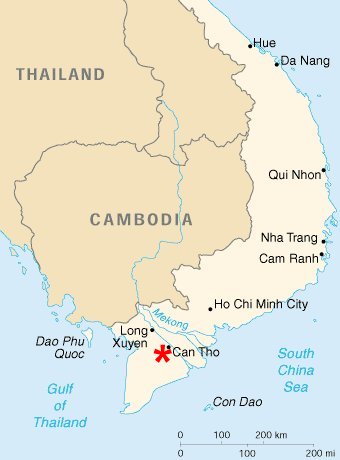
Can Tho International Airport (IATA: VCA, ICAO: VVCT) (Vietnamese: Sân bay Quốc tế Cần Thơ), formerly Trà Nóc Airport is located in Can Tho city in Mekong Delta region of Vietnam.
The airport is under major reconstruction which is scheduled to finish by 2010, then the airport will serve international flights, mainly in Asian region.
|
Contents
- 1 Upgrading of Trà Nóc airport
- 2 Destination
- 3 History
- 4 References
- 5 See also
- 6 External links
|
[edit] Upgrading of Trà Nóc airport
The expansion work of Trà Nóc airport started in 4 January 2006. The project will be implemented in two phases, covering an area of 85.04ha.
- Phase 1: due to be completed in 2008, work including: improvement of the paved runway (2,400 m x 45 m), apron (27,491 m2), cost estimate: 370 billion VND ($ 23 million). Upon completion, this airport will be capable to handle medium range aircraft like A320, A321, B767.
- Phase 2: construction of a terminal (19,000 m2), cargo terminal and other facilities. Cost estimate: 400 - 500 billion VND ($25 to 31 million). The capacity of this terminal is 2 million passengers per year.
[edit] Destination
| Airlines |
Destinations |
| Vietnam Airlines |
Hanoi, Ho Chi Minh City, Phu Quoc |
Vietnam Airlines plans to open flights linking Trà Nóc airport to Da Nang International Airport, Singapore Changi Airport, Suvarnabhumi Airport and Cambodia.
History
Trà Nóc Airport was originally constructed during the Vietnam War in 1965 by United States Air Force (USAF) civil engineering units as a military airfield. It was used by the USAF as well as being the Headquarters of the Republic of Vietnam Air Force (VNAF) 4th Air Division until 1975.
After 1975, the facility was initially unused, then later operated as a small regional airport for Can Tho. It is currently being expanded and upgraded to international status, with completion due in 2008.
The above content comes from Wikipedia and is published under free licenses – click here to read more.
| General Info
|
| Country |
Vietnam
|
| ICAO ID |
VVCT
|
| Time |
UTC+7
|
| Latitude |
10.085119
10° 05' 06.43" N
|
| Longitude |
105.711922
105° 42' 42.92" E
|
| Elevation |
9 feet
3 meters
|
| Magnetic Variation |
000° W (01/06)
|
| Operating Agency |
CIVIL GOVERNMENT, (LANDING FEES AND DIPLOMATIC CLEARANCE MAY BE REQUIRED)
|
| Alternate Name |
TRA NOC
|
| Operating Hours |
UNKNOWN
|
| Runways
|
| ID |
Dimensions |
Surface |
PCN |
ILS
|
| 06/24 |
7886 x 100 feet
2404 x 30 meters |
ASPHALT |
- |
NO
|
| Navaids
|
| Type |
ID |
Name |
Channel |
Freq |
Distance From Field |
Bearing From Navaid
|
| NDB |
CT |
CAN THO |
- |
420 |
1.1 NM |
251.2
|
The content above was published at Airports-Worldwide.com in 2010.
We don't guarantee the information is fresh and accurate. The data may be wrong or outdated.
For more up-to-date information please refer to other sources.
|
|