 |
|
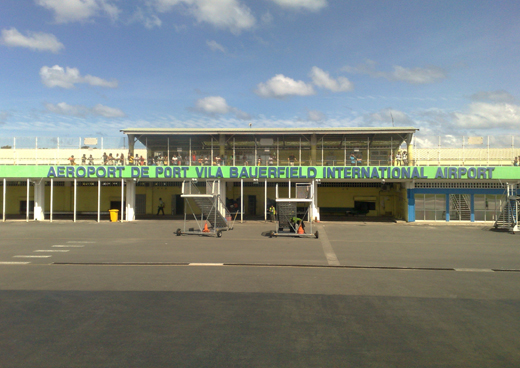
Port Vila Bauerfield Airport |
Bauerfield International Airport
Port Vila International Airport |
 |
| IATA: VLI – ICAO: NVVV |
| Summary |
| Airport type |
Public |
| Operator |
Airports Vanuatu Limited |
| Serves |
Port Vila, Vanuatu |
| Hub for |
Air Vanuatu |
| Elevation AMSL |
68 ft / 21 m |
| Coordinates |
17°41′57″S 168°19′11″E / 17.69917°S 168.31972°E / -17.69917; 168.31972 |
| Runways |
| Direction |
Length |
Surface |
| m |
ft |
| 11/29 |
2,600 |
8,530 |
Asphalt |
Bauerfield International Airport (IATA: VLI, ICAO: NVVV) is an airport located in Port Vila, Vanuatu. The airport is relatively small in size, but its runway has the capability and length to accept jets up to the Boeing 767. It serves as the hub for Vanuatu's flag carrier airline, Air Vanuatu.
The airport was named after Lt-Col. Harold Bauer, a fighter pilot in the US Marine Corps during World War II.
Airlines and destinations
| Airlines |
Destinations |
| Aircalin |
Nouméa |
| Air New Zealand |
Auckland |
| Air Pacific |
Nadi, Honiara |
| Air Vanuatu |
Aniwa, Auckland, Brisbane, Craig Cove, Dillon's Bay, Emae, Ipota, Lamap, Lamen Bay, Longana, Lonorore, Luganville, Melbourne, Norsup, Nouméa, Paama, Sara, Sota, South West Bay, Sydney, Tanna, Tongoa, Torres, Ulei, Valesdir, Walaha |
| Virgin Blue operated by Pacific Blue Airlines |
Brisbane, Sydney |
The above content comes from Wikipedia and is published under free licenses – click here to read more.
| General Info
|
| Country |
Vanuatu
|
| ICAO ID |
NVVV
|
| Time |
UTC+11(+12DT)
|
| Latitude |
-17.699325
17° 41' 57.57" S
|
| Longitude |
168.319794
168° 19' 11.26" E
|
| Elevation |
70 feet
21 meters
|
| Type |
Civil
|
| Magnetic Variation |
011° E (01/06)
|
| Operating Agency |
CIVIL GOVERNMENT, (LANDING FEES AND DIPLOMATIC CLEARANCE MAY BE REQUIRED)
|
| Island Group |
Efate I
|
| Operating Hours |
SEE REMARKS FOR OPERATING HOURS OR COMMUNICATIONS FOR POSSIBLE HOURS
|
| International Clearance Status |
Airport of Entry
|
| Communications
|
TWR
By NOTAM.
|
120.7
6553
8846
118.3
3425
|
CTAF
When ATC unavbl, mand bcst rqr wi 10 NM rad, Sfc-3000'.
|
120.7
|
FLT SVC
By NOTAM.
|
120.7
6553
8846
118.3
3425
|
| Runways
|
| ID |
Dimensions |
Surface |
PCN |
ILS
|
| 11/29 |
8530 x 148 feet
2600 x 45 meters |
ASPHALT |
055FBWT |
YES
|
| 11R/29L |
3310 x 105 feet
1009 x 32 meters |
GRASS OR EARTH NOT GRADED OR ROLLED. |
- |
NO
|
| Navaids
|
| Type |
ID |
Name |
Channel |
Freq |
Distance From Field |
Bearing From Navaid
|
| VOR-DME |
VLI |
BAUERFIELD |
090X |
114.3 |
4.9 NM |
117.0
|
| NDB |
BA |
BAUERFIELD |
- |
361 |
3.0 NM |
097.9
|
| Supplies/Equipment
|
| Fuel |
Jet A1+, Jet A1 with icing inhibitor.
Jet A1, without icing nhibitor.
100/130 octane gasoline, leaded, MIL-L-5572F (GREEN)
|
| Remarks
|
| CAUTION |
Trees penetrate apch and dep slope. Trees up to 100' tall infringe both sides ofrwy. Care rqr dur ldg/tkof with cautious use of wheel breaking. BASH.
|
| FUEL |
PN rqr before 0400Z Fri, and 48 hr PN on Sat, Sun or Hol. (NC-100, A1+).
|
| LGT |
Tmpry lgt O/R 1 hr. Bdry lgt avbl. PAPI: Rwy 11 TCH 50', Rwy 29 GS 3.5 , TCH 60'. Rwy 11 strobe lgt unuse.
|
| OPR HOURS |
Opr - By NOTAM.
|
| RSTD |
Proh to NORDO.
|
| TFC PAT |
Rwy 11-rgt tfc.
|
The content above was published at Airports-Worldwide.com in 2010.
We don't guarantee the information is fresh and accurate. The data may be wrong or outdated.
For more up-to-date information please refer to other sources.
|
|


