 |
|
| Yellowstone Regional Airport |
| IATA: COD – ICAO: KCOD – FAA LID: COD |
| Summary |
| Airport type |
Public |
| Owner |
City of Cody |
| Serves |
Cody, Wyoming |
| Elevation AMSL |
5,102 ft / 1,555 m |
| Coordinates |
44°31′13″N 109°01′26″W / 44.52028°N 109.02389°W / 44.52028; -109.02389 |
| Website |
www.FlyYRA.com |
| Runways |
| Direction |
Length |
Surface |
| ft |
m |
| 4/22 |
8,268 |
2,520 |
Asphalt |
| Statistics (2008) |
| Aircraft operations |
37,490 |
| Based aircraft |
68 |
| Source: Federal Aviation Administration |
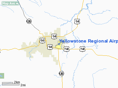
Yellowstone Regional Airport (IATA: COD, ICAO: KCOD, FAA LID: COD) is a public-use airport located two nautical miles (3.7 km) southeast of the central business district of Cody, a city in Park County, Wyoming, United States. It is the only commercial airport in Park County. This puts it in northwestern Wyoming, about 53 miles from the east entrance of Yellowstone National Park.
The airport is owned by the city of Cody, WY and is operated by the Yellowstone Regional Airport Joint Powers Board. This board was established in 1981 and is made up of 7 members appointed the Cody City Council and the Park County Commission. The daily operations of the airport are overseen by an Airport Manager, who is appointed by the board.
It should not be confused with Yellowstone Airport, located 104 miles (167 km) away in West Yellowstone, Montana, near the west entrance to Yellowstone National Park. Facilities and aircraft
Yellowstone Regional Airport covers an area of 694 acres (281 ha) at an elevation of 5,102 feet (1,555 m) above mean sea level. It has one runway designated 4/22 with an asphalt surface measuring 8,268 by 100 feet (2,520 x 30 m).
For the 12-month period ending December 31, 2008, the airport had 37,490 aircraft operations, an average of 102 per day: 83% general aviation, 17% air taxi, and <1% military. At that time there were 68 aircraft based at this airport: 82% single-engine, 6% multi-engine, 7% jet, 3% helicopter, and 2% glider.
A new $12.5 million airport terminal is currently under construction and is scheduled for completion in December 2010. 95% of the cost for the new terminal is paid with an FAA grant, 3% is coming from the Wyoming State Aeronautics Division and the remaining 2% comes from the airport itself.
Choice Aviation and Spirit Mountain Aviation, the airport's fixed base operators (FBOs), offer fuel, flight instruction, aircraft/hanger rental, and other services.
Airlines and destinations
| Airlines |
Destinations |
| Delta Connection operated by SkyWest Airlines |
Salt Lake City |
| United Express operated by SkyWest Airlines |
Denver |
Air cargo
UPS and FedEx both offer air cargo services at the airport.
Ground transportation
Budget, Hertz, and Thrifty all offer rental cars at the airport.
Passenger services
Yellowstone Regional Airport offers free Wi-Fi Internet service in its terminal. In addition, food and beverage service is available at a restaurant at the airport.
The above content comes from Wikipedia and is published under free licenses – click here to read more.
Location & QuickFacts
| FAA Information Effective: | 2008-09-25 |
| Airport Identifier: | COD |
| Airport Status: | Operational |
| Longitude/Latitude: | 109-01-25.7000W/44-31-12.7000N
-109.023806/44.520194 (Estimated) |
| Elevation: | 5102 ft / 1555.09 m (Surveyed) |
| Land: | 694 acres |
| From nearest city: | 2 nautical miles SE of Cody, WY |
| Location: | Park County, WY |
| Magnetic Variation: | 14E (1995) |
Owner & Manager
| Ownership: | Publicly owned |
| Owner: | City Of Cody |
| Address: | 1338 Rumsey Ave
Cody, WY 82414 |
| Phone number: | 307-527-7511 |
| Manager: | Bob Hooper |
| Address: | Po Box 2748
Cody, WY 82414 |
| Phone number: | 307-587-5096 |
Airport Operations and Facilities
| Airport Use: | Open to public |
| Wind indicator: | Yes |
| Segmented Circle: | Yes |
| Control Tower: | No |
| Lighting Schedule: | DUSK-DAWN
ACTVT MIRL RY 04/22, REIL RY 04 & RY 22, PAPI RY 04 & RY 22 - CTAF. |
| Beacon Color: | Clear-Green (lighted land airport) |
| Landing fee charge: | No |
| Sectional chart: | Great Falls |
| Region: | ANM - Northwest Mountain |
| Boundary ARTCC: | ZLC - Salt Lake City |
| Tie-in FSS: | CPR - Casper |
| FSS on Airport: | No |
| FSS Toll Free: | 1-800-WX-BRIEF |
| NOTAMs Facility: | COD (NOTAM-d service avaliable) |
| Certification type/date: | I A S 05/1973
CLSD TO UNSKED ACR OPNS WITH MORE THAN 30 PSGR SEATS EXCP PPR CALL AMGR 307-587-5096. |
| Federal Agreements: | NGY |
Airport Communications
| CTAF: | 122.800 |
| Unicom: | 122.800 |
Airport Services
| Fuel available: | 100 A |
| Airframe Repair: | MAJOR |
| Power Plant Repair: | MAJOR |
| Bottled Oxygen: | NONE |
| Bulk Oxygen: | HIGH |
Runway Information
Runway 04/22
| Dimension: | 8268 x 100 ft / 2520.1 x 30.5 m |
| Surface: | ASPH, Good Condition |
| Surface Treatment: | Saw-cut or plastic Grooved |
| Weight Limit: | Single wheel: 45000 lbs.
Dual wheel: 80000 lbs. |
| Edge Lights: | Medium |
| |
Runway 04 |
Runway 22 |
| Longitude: | 109-02-10.8635W | 109-00-40.5835W |
| Latitude: | 44-30-47.7484N | 44-31-37.6485N |
| Elevation: | 5102.00 ft | 5075.00 ft |
| Alignment: | 52 | 127 |
| Traffic Pattern: | Left | Left |
| Markings: | Precision instrument, Fair Condition | Precision instrument, Fair Condition |
| Crossing Height: | 50.00 ft | 50.00 ft |
| Displaced threshold: | 690.00 ft | 400.00 ft |
| VASI: | 4-light PAPI on left side | 4-light PAPI on left side |
| Visual Glide Angle: | 3.50° | 3.00° |
| Runway End Identifier: | Yes | Yes |
| Obstruction: | 22 ft road, 725.0 ft from runway, 23:1 slope to clear
+345' POLES ON HILL ON CNTRLN EXTDD. | 55 ft gnd, 2087.0 ft from runway, 404 ft left of centerline, 34:1 slope to clear
+84' POLES ON HILL ON CNTRLN EXTDD. |
| Decleard distances: | Take off run available 8268.00 ft
Take off distance available 8268.00 ft
Actual stop distance available 7868.00 ft
Landing distance available 7178.00 ft
| Take off run available 8268.00 ft
Take off distance available 8268.00 ft
Actual stop distance available 7578.00 ft
Landing distance available 7178.00 ft
|
|
Radio Navigation Aids
| ID |
Type |
Name |
Ch |
Freq |
Var |
Dist |
| POY | NDB | Powell | | 344.00 | 15E | 23.2 nm |
| HCY | NDB | Cowley | | 257.00 | 14E | 34.3 nm |
| GEY | NDB | Greybull | | 275.00 | 14E | 40.3 nm |
| RED | NDB | Red Lodge | | 203.00 | 17E | 44.5 nm |
| COD | VOR/DME | Cody | 055X | 111.80 | 14E | 6.5 nm |
Remarks
- LOW LEVEL WATERFOWL ON LAKE 1/4 MILE 'SE' OF RY 4 THLD.
Images and information placed above are from
http://www.airport-data.com/airport/COD/
We thank them for the data!
| General Info
|
| Country |
United States
|
| State |
WYOMING
|
| FAA ID |
COD
|
| Latitude |
44-31-12.700N
|
| Longitude |
109-01-25.700W
|
| Elevation |
5102 feet
|
| Near City |
CODY
|
We don't guarantee the information is fresh and accurate. The data may
be wrong or outdated.
For more up-to-date information please refer to other sources.
|
|


