 |
|
Coordinates: 43°57′57″N 107°57′03″W / 43.96583°N 107.95083°W / 43.96583; -107.95083
| Worland Municipal Airport |
| IATA: WRL – ICAO: KWRL – FAA LID: WRL |
| Summary |
| Airport type |
Public |
| Owner |
City of Worland |
| Location |
Worland, Wyoming |
| Elevation AMSL |
4,227 ft / 1,288 m |
| Runways |
| Direction |
Length |
Surface |
| ft |
m |
| 16/34 |
7,005 |
2,135 |
Asphalt |
| 10/28 |
2,501 |
762 |
Turf |
| 4/22 |
2,241 |
683 |
Turf |
| Statistics (2005) |
| Aircraft operations |
7,427 |
| Source: Federal Aviation Administration |
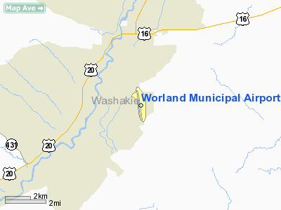
Worland Municipal Airport (IATA: WRL, ICAO: KWRL, FAA LID: WRL) is a public airport located three miles (5 km) south of the central business district of Worland, a city in Washakie County, Wyoming, United States, and was originally constructed in 1953. It is owned by the City of Worland. The airport is mostly used for general aviation, but is also served by one commercial airline. Service is subsidized by the Essential Air Service program.
As per Federal Aviation Administration records, the airport had 1,947 passenger boardings (enplanements) in calendar year 2005. According to the FAA's National Plan of Integrated Airport Systems for 2007-2011, Worland Municipal is a general aviation airport because a commercial service classification requires at least 2,500 passenger boardings per year. Airlines and destinations
| Airlines |
Destinations |
| Great Lakes Airlines |
Denver, Lewistown |
Facilities and aircraft
Worland Municipal Airport covers an area of 690 acres (279 ha) which contains three runways:
- Runway 16/34: 7,005 x 100 ft (2,135 x 30 m), Surface: Asphalt
- Runway 10/28: 2,501 x 60 ft (762 x 18 m), Surface: Turf
- Runway 4/22: 2,241 x 60 ft (683 x 18 m), Surface: Turf
For the 12-month period ending October 31, 2005, the airport had 7,427 aircraft operations, an average of 20 per day: 47% general aviation, 43% air taxi, 9% scheduled commercial and <1% military.
The above content comes from Wikipedia and is published under free licenses – click here to read more.
Location & QuickFacts
| FAA Information Effective: | 2008-09-25 |
| Airport Identifier: | WRL |
| Airport Status: | Operational |
| Longitude/Latitude: | 107-57-02.9910W/43-57-56.5670N
-107.950831/43.965713 (Estimated) |
| Elevation: | 4227 ft / 1288.39 m (Surveyed) |
| Land: | 690 acres |
| From nearest city: | 3 nautical miles S of Worland, WY |
| Location: | Washakie County, WY |
| Magnetic Variation: | 13E (1995) |
Owner & Manager
| Ownership: | Publicly owned |
| Owner: | City Of Worland |
| Address: | P.o. Box 226
Worland, WY 82401 |
| Phone number: | 307-347-2486 |
| Manager: | Gary Thompson |
| Address: | 1438 Airport Road
Worland, WY 82401 |
| Phone number: | 307-347-8977 |
Airport Operations and Facilities
| Airport Use: | Open to public |
| Wind indicator: | Yes |
| Segmented Circle: | Yes |
| Control Tower: | No |
| Lighting Schedule: | DUSK-DAWN
ACTVT MIRL RY 16/34 AND REIL RYS 16 & 34, AND VASI RYS 16 & 34 - CTAF. |
| Beacon Color: | Clear-Green (lighted land airport) |
| Landing fee charge: | No |
| Sectional chart: | Cheyenne |
| Region: | ANM - Northwest Mountain |
| Boundary ARTCC: | ZLC - Salt Lake City |
| Tie-in FSS: | CPR - Casper |
| FSS Toll Free: | 1-800-WX-BRIEF |
| NOTAMs Facility: | WRL (NOTAM-d service avaliable) |
| Certification type/date: | I A U 05/1973
CLSD TO ACR OPNS WITH MORE THAN 30 PSGR SEATS |
| Federal Agreements: | NGSY |
Airport Communications
| CTAF: | 123.050 |
| Unicom: | 123.050 |
Airport Services
| Fuel available: | 100LLA |
| Airframe Repair: | MAJOR |
| Power Plant Repair: | MAJOR |
| Bottled Oxygen: | NONE |
Runway Information
Runway 04/22
| Dimension: | 2241 x 60 ft / 683.1 x 18.3 m |
| Surface: | TURF, Fair Condition |
| |
Runway 04 |
Runway 22 |
| Longitude: | 107-57-01.5930W | 107-56-35.9310W |
| Latitude: | 43-57-39.2680N | 43-57-51.3420N |
| Elevation: | 4212.00 ft | 4222.00 ft |
| Alignment: | 57 | 127 |
| Traffic Pattern: | Left | Left |
|
Runway 10/28
| Dimension: | 2501 x 60 ft / 762.3 x 18.3 m |
| Surface: | TURF, Fair Condition |
| |
Runway 10 |
Runway 28 |
| Longitude: | 107-57-07.3230W | 107-56-37.2840W |
| Latitude: | 43-58-03.5290N | 43-57-51.7480N |
| Elevation: | 4182.00 ft | 4220.00 ft |
| Alignment: | 119 | 127 |
| Traffic Pattern: | Left | Left |
|
Runway 16/34
| Dimension: | 7005 x 100 ft / 2135.1 x 30.5 m |
| Surface: | ASPH, Good Condition |
| Surface Treatment: | Porous Friction Course |
| Weight Limit: | Single wheel: 40000 lbs.
Dual wheel: 55000 lbs. |
| Edge Lights: | Medium |
| |
Runway 16 |
Runway 34 |
| Longitude: | 107-57-15.5040W | 107-57-07.2140W |
| Latitude: | 43-58-34.2360N | 43-57-25.3380N |
| Elevation: | 4161.00 ft | 4227.00 ft |
| Alignment: | 127 | 127 |
| Traffic Pattern: | Left | Left |
| Markings: | Non-precision instrument, Good Condition | Non-precision instrument, Good Condition |
| Crossing Height: | 41.00 ft | 41.00 ft |
| VASI: | 4-box on left side | 4-box on left side |
| Visual Glide Angle: | 3.00° | 3.00° |
| Runway End Identifier: | Yes | Yes |
| Obstruction: | 64 ft tree, 2235.0 ft from runway, 553 ft left of centerline, 31:1 slope to clear | 3 ft gnd, 3.0 ft from runway, 7 ft left of centerline, 34:1 slope to clear |
|
Radio Navigation Aids
| ID |
Type |
Name |
Ch |
Freq |
Var |
Dist |
| GEY | NDB | Greybull | | 275.00 | 14E | 33.3 nm |
| BOY | VOR/DME | Boysen Reservoir | 125X | 117.80 | 16E | 33.8 nm |
Remarks
- WIND PERMITTING LAND RY 16.
- RYS 04/22 & 10/28 CLSD OCT 30 - MAR 30 YEARLY.
Images and information placed above are from
http://www.airport-data.com/airport/WRL/
We thank them for the data!
| General Info
|
| Country |
United States
|
| State |
WYOMING
|
| FAA ID |
WRL
|
| Latitude |
43-57-56.567N
|
| Longitude |
107-57-02.991W
|
| Elevation |
4227 feet
|
| Near City |
WORLAND
|
We don't guarantee the information is fresh and accurate. The data may
be wrong or outdated.
For more up-to-date information please refer to other sources.
|
|


