 |
|
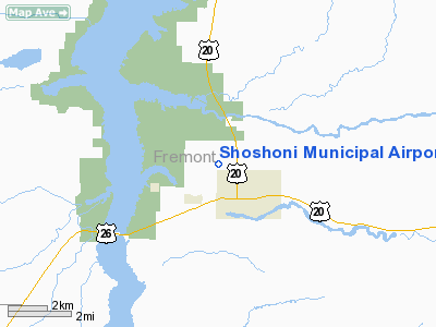
Location & QuickFacts
| FAA Information Effective: | 2008-09-25 |
| Airport Identifier: | 49U |
| Airport Status: | Operational |
| Longitude/Latitude: | 108-07-17.3390W/43-15-04.8490N
-108.121483/43.251347 (Estimated) |
| Elevation: | 4817 ft / 1468.22 m (Estimated) |
| Land: | 320 acres |
| From nearest city: | 1 nautical miles N of Shoshoni, WY |
| Location: | Fremont County, WY |
| Magnetic Variation: | 14E (1985) |
Owner & Manager
| Ownership: | Publicly owned |
| Owner: | Town Of Shoshoni |
| Address: | Po Box 267
Shoshoni, WY 82649 |
| Phone number: | 307-876-2515 |
| Manager: | Thomas Currah
TOWN MAYOR. |
| Address: | Box 267
Shoshoni, WY 82649 |
| Phone number: | 307-876-2515 |
Airport Operations and Facilities
| Airport Use: | Open to public |
| Wind indicator: | Yes |
| Segmented Circle: | Yes |
| Control Tower: | No |
| Landing fee charge: | No |
| Sectional chart: | Cheyenne |
| Region: | ANM - Northwest Mountain |
| Boundary ARTCC: | ZLC - Salt Lake City |
| Tie-in FSS: | CPR - Casper |
| FSS on Airport: | No |
| FSS Toll Free: | 1-800-WX-BRIEF |
| NOTAMs Facility: | CPR (NOTAM-d service avaliable) |
| Federal Agreements: | 1 |
Airport Communications
Airport Services
| Airframe Repair: | NONE |
| Power Plant Repair: | NONE |
| Bottled Oxygen: | NONE |
| Bulk Oxygen: | NONE |
Runway Information
Runway 08/26
| Dimension: | 4650 x 90 ft / 1417.3 x 27.4 m |
| Surface: | DIRT, Good Condition
NUMEROUS ROCKS ON RY SFC; RY SOFT WHEN WET.
NUMEROUS ROCKS ON RY SFC; RY SOFT WHEN WET. |
| |
Runway 08 |
Runway 26 |
| Traffic Pattern: | Left | Left |
| Obstruction: | 39 ft pline, 312.0 ft from runway, 8:1 slope to clear | 8 ft fence, 132.0 ft from runway, 16:1 slope to clear |
|
Runway 11/29
| Dimension: | 2950 x 75 ft / 899.2 x 22.9 m |
| Surface: | DIRT, Good Condition
NUMEROUS ROCKS ON RY SFC; RY SOFT WHEN WET.
NUMEROUS ROCKS ON RY SFC; RY SOFT WHEN WET. |
| |
Runway 11 |
Runway 29 |
| Traffic Pattern: | Left | Left |
| Obstruction: | 7 ft fence, 93.0 ft from runway, 13:1 slope to clear | , 50:1 slope to clear |
|
Radio Navigation Aids
| ID |
Type |
Name |
Ch |
Freq |
Var |
Dist |
| BOY | VOR/DME | Boysen Reservoir | 125X | 117.80 | 16E | 14.9 nm |
| RIW | VOR/DME | Riverton | 025X | 108.80 | 16E | 18.4 nm |
| RLY | VOR/DME | Worland | 095X | 114.80 | 13E | 43.5 nm |
Remarks
- ARPT HAS UNCONTROLLED VEHICLE ACCESS.
- RYS 08/26 & 11/29 THLDS NOT MARKED.
- RY 08/26 NO LINE OF SIGHT BTN RY ENDS.
- ANTELOPE ON AIRPORT.
- +2 FT BERMS EITHER SIDE OF BOTH RYS.
- +8 INCH ANT HILLS ON SFC OF ALL RYS.
Images and information placed above are from
http://www.airport-data.com/airport/49U/
We thank them for the data!
| General Info
|
| Country |
United States
|
| State |
WYOMING
|
| FAA ID |
49U
|
| Latitude |
43-15-04.849N
|
| Longitude |
108-07-17.339W
|
| Elevation |
4817 feet
|
| Near City |
SHOSHONI
|
We don't guarantee the information is fresh and accurate. The data may
be wrong or outdated.
For more up-to-date information please refer to other sources.
|
|


