 |
|
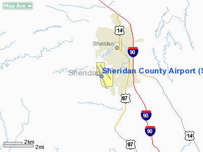
| Sheridan County Airport |
| IATA: SHR – ICAO: KSHR – FAA LID: SHR |
| Summary |
| Airport type |
Public |
| Operator |
Sheridan County |
| Location |
Sheridan, Wyoming and H.F. BAR RANCH |
| Elevation AMSL |
4,021 ft / 1,225.6 m |
| Coordinates |
44°46′09″N 106°58′49″W / 44.76917°N 106.98028°W / 44.76917; -106.98028Coordinates: 44°46′09″N 106°58′49″W / 44.76917°N 106.98028°W / 44.76917; -106.98028 |
| Runways |
| Direction |
Length |
Surface |
| ft |
m |
| 14/32 |
8,300 |
2,530 |
Asphalt |
| 5/23 |
5,039 |
1,536 |
Asphalt |
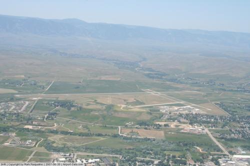
Sheridan County Airport (IATA: SHR, ICAO: KSHR, FAA LID: SHR) is a public airport located two miles (3 km) southwest of the central business district (CBD) of Sheridan, a city in Sheridan County, Wyoming, USA. The airport covers 1,550 acres (627 ha) and has two runways. It is mainly used for general aviation, but is also served by two commercial airlines.
Service was subsidized by the Essential Air Service program until February 1, 2007, when Big Sky Airlines began providing subsidy free service.
Bighorn Airways offers airplane and helicopter air charter service, as well as an aircraft repair and installation center. Cheyenne, WY based Great Lakes Airlines offers service to Denver, CO. Airlines and destinations
| Airlines |
Destinations |
| Great Lakes Airlines |
Denver |
The above content comes from Wikipedia and is published under free licenses – click here to read more.
 |
(Click on the photo to enlarge) |
Location & QuickFacts
| FAA Information Effective: | 2008-09-25 |
| Airport Identifier: | SHR |
| Airport Status: | Operational |
| Longitude/Latitude: | 106-58-49.0000W/44-46-09.1000N
-106.980278/44.769194 (Estimated) |
| Elevation: | 4021 ft / 1225.60 m (Surveyed) |
| Land: | 1550 acres |
| From nearest city: | 2 nautical miles SW of Sheridan, WY |
| Location: | Sheridan County, WY |
| Magnetic Variation: | 13E (1990) |
Owner & Manager
| Ownership: | Publicly owned |
| Owner: | Sheridan County |
| Address: | 908 W Brundage Lane
Sheridan, WY 82801-5896 |
| Phone number: | 307-674-4222 |
| Manager: | John Stopka |
| Address: | 908 West Brundage Lane
Sheridan, WY 82801-5827 |
| Phone number: | 307-674-4222 |
Airport Operations and Facilities
| Airport Use: | Open to public |
| Wind indicator: | Yes |
| Segmented Circle: | Yes |
| Control Tower: | No |
| Lighting Schedule: | DUSK-DAWN
ACTVT MIRL RY 05-23, HIRL RY 14-32, MALSR RY 32, REIL RYS 05, 23 & 14, & PAPI RYS 14, 32, 05 AND 23 - CTAF. |
| Beacon Color: | Clear-Green (lighted land airport) |
| Landing fee charge: | No |
| Sectional chart: | Billings |
| Region: | ANM - Northwest Mountain |
| Traffic Pattern Alt: | 800 ft |
| Boundary ARTCC: | ZLC - Salt Lake City |
| Tie-in FSS: | CPR - Casper |
| FSS Toll Free: | 1-800-WX-BRIEF |
| NOTAMs Facility: | SHR (NOTAM-d service avaliable) |
| Certification type/date: | I A S 05/1973
PPR UNSCHEDULED ACR OPNS WITH MORE THAN 30 PSGR SEATS CTC ARFF STATION 307-673-1875. |
| Federal Agreements: | NGY3 |
Airport Communications
| CTAF: | 123.000 |
| Unicom: | 123.000 |
Airport Services
| Fuel available: | 100 A A1+ |
| Airframe Repair: | MAJOR |
| Power Plant Repair: | MAJOR |
| Bottled Oxygen: | HIGH |
| Bulk Oxygen: | HIGH/LOW |
Runway Information
Runway 05/23
| Dimension: | 5039 x 75 ft / 1535.9 x 22.9 m |
| Surface: | ASPH, Good Condition |
| Surface Treatment: | Saw-cut or plastic Grooved |
| Weight Limit: | Single wheel: 36000 lbs.
Dual wheel: 50000 lbs. |
| Edge Lights: | Medium |
| |
Runway 05 |
Runway 23 |
| Longitude: | 106-59-15.1524W | 106-58-10.4109W |
| Latitude: | 44-46-15.1643N | 44-46-33.8047N |
| Elevation: | 4021.00 ft | 3939.00 ft |
| Alignment: | 68 | 127 |
| Traffic Pattern: | Left | Left |
| Markings: | Non-precision instrument, Good Condition | Non-precision instrument, Good Condition |
| Crossing Height: | 35.00 ft | 38.00 ft |
| VASI: | 4-light PAPI on left side | 4-light PAPI on left side |
| Visual Glide Angle: | 3.00° | 3.00° |
| Runway End Identifier: | Yes | Yes |
| Obstruction: | , 50:1 slope to clear | 40 ft trees, 750.0 ft from runway, 200 ft right of centerline, 20:1 slope to clear |
|
Runway 14/32
| Dimension: | 8300 x 100 ft / 2529.8 x 30.5 m |
| Surface: | ASPH, Good Condition |
| Surface Treatment: | Porous Friction Course |
| Weight Limit: | Single wheel: 60000 lbs.
Dual wheel: 75000 lbs. |
| Edge Lights: | High |
| |
Runway 14 |
Runway 32 |
| Longitude: | 106-59-15.9182W | 106-58-29.7190W |
| Latitude: | 44-46-37.3128N | 44-45-22.2693N |
| Elevation: | 4014.00 ft | 3976.00 ft |
| Alignment: | 127 | 127 |
| ILS Type: | | ILS/DME
|
| Traffic Pattern: | Left | Left |
| Markings: | Non-precision instrument, Good Condition | Precision instrument, Good Condition |
| Crossing Height: | 51.00 ft | 53.00 ft |
| VASI: | 4-light PAPI on left side | 4-light PAPI on left side |
| Visual Glide Angle: | 3.00° | 3.00° |
| Approach lights: | | MALSR |
| Runway End Identifier: | Yes | |
|
Radio Navigation Aids
| ID |
Type |
Name |
Ch |
Freq |
Var |
Dist |
| GEY | NDB | Greybull | | 275.00 | 14E | 49.6 nm |
| SHR | VORTAC | Sheridan | 100X | 115.30 | 13E | 5.6 nm |
Remarks
- FIXED WING ACFT RESTRICTED TO RYS & TWYS ONLY.
- GLIDER ACTIVITY ON AND INVOF ARPT.
Images and information placed above are from
http://www.airport-data.com/airport/SHR/
We thank them for the data!
| General Info
|
| Country |
United States
|
| State |
WYOMING
|
| FAA ID |
SHR
|
| Latitude |
44-46-09.104N
|
| Longitude |
106-58-49.006W
|
| Elevation |
4024 feet
|
| Near City |
SHERIDAN
|
We don't guarantee the information is fresh and accurate. The data may
be wrong or outdated.
For more up-to-date information please refer to other sources.
|
|


