 |
|
Rawlins Muni/harvey Field Airport |
Coordinates: 41°48′20″N 107°12′0″W / 41.80556°N 107.2°W / 41.80556; -107.2
Rawlins Municipal Airport
Harvey Field |
| IATA: RWL – ICAO: KRWL – FAA LID: RWL |
| Summary |
| Airport type |
Public |
| Owner |
Rawlins Carbon County Airport Board |
| Serves |
Rawlins, Wyoming |
| Elevation AMSL |
6,813 ft / 2,077 m |
| Website |
www.rawlinsairportboard.com |
| Runways |
| Direction |
Length |
Surface |
| ft |
m |
| 4/22 |
7,008 |
2,136 |
Asphalt |
| 10/28 |
4,118 |
1,255 |
Asphalt |
| Statistics (2006) |
| Aircraft operations |
10,020 |
| Source: Federal Aviation Administration |
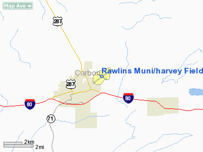
Rawlins Municipal Airport (IATA: RWL, ICAO: KRWL, FAA LID: RWL), also known as Harvey Field, is a public airport located two miles (3 km) northeast of the central business district of Rawlins, a city in Carbon County, Wyoming, United States. It is owned by the Rawlins Carbon County Airport Board.
Facilities and aircraft
Rawlins Municipal Airport/Harvey Field covers an area of 800 acres (324 ha) which contains two asphalt paved runways: 4/22 measuring 7,008 x 100 ft (2,136 x 30 m) and 10/28 measuring 4,118 x 60 ft (1,255 x 18 m). For the 12-month period ending July 31, 2006, the airport had 10,020 aircraft operations, an average of 27 per day: 56% general aviation, 43% air taxi and 1% military.
The above content comes from Wikipedia and is published under free licenses – click here to read more.
Location & QuickFacts
| FAA Information Effective: | 2008-09-25 |
| Airport Identifier: | RWL |
| Airport Status: | Operational |
| Longitude/Latitude: | 107-11-59.7840W/41-48-20.1510N
-107.199940/41.805598 (Estimated) |
| Elevation: | 6813 ft / 2076.60 m (Surveyed) |
| Land: | 800 acres |
| From nearest city: | 2 nautical miles NE of Rawlins, WY |
| Location: | Carbon County, WY |
| Magnetic Variation: | 13E (1985) |
Owner & Manager
| Ownership: | Publicly owned |
| Owner: | Rawlins Carbon Co Arpt Board |
| Address: | Box 7
Rawlins, WY 82301 |
| Phone number: | 307-324-2361 |
| Manager: | Dwight France |
| Address: | Po Box 606
Rawlins, WY 82301 |
| Phone number: | 307-324-2361 |
Airport Operations and Facilities
| Airport Use: | Open to public |
| Wind indicator: | Yes |
| Segmented Circle: | Yes |
| Control Tower: | No |
| Lighting Schedule: | DUSK-DAWN
ACTVT MIRL RYS 04/22 & 10/28, & REIL RYS 22 & 28 - CTAF. |
| Beacon Color: | Clear-Green (lighted land airport) |
| Landing fee charge: | No |
| Sectional chart: | Cheyenne |
| Region: | ANM - Northwest Mountain |
| Boundary ARTCC: | ZDV - Denver |
| Tie-in FSS: | CPR - Casper |
| FSS Toll Free: | 1-800-WX-BRIEF |
| NOTAMs Facility: | RWL (NOTAM-d service avaliable) |
| Federal Agreements: | NGSY |
Airport Communications
| CTAF: | 123.000 |
| Unicom: | 123.000 |
Airport Services
| Fuel available: | 100LLA
FOR FUEL AFTER HOURS CALL 307-324-2361 OR 307-321-3722. |
| Airframe Repair: | MAJOR |
| Power Plant Repair: | MAJOR |
| Bottled Oxygen: | NONE |
| Bulk Oxygen: | HIGH |
Runway Information
Runway 04/22
| Dimension: | 7008 x 100 ft / 2136.0 x 30.5 m |
| Surface: | ASPH, Good Condition |
| Surface Treatment: | Porous Friction Course |
| Weight Limit: | Single wheel: 30000 lbs.
Dual wheel: 60000 lbs. |
| Edge Lights: | Medium |
| |
Runway 04 |
Runway 22 |
| Longitude: | 107-12-36.6560W | 107-11-21.7670W |
| Latitude: | 41-48-00.2620N | 41-48-40.8930N |
| Elevation: | 6741.00 ft | 6813.00 ft |
| Alignment: | 54 | 127 |
| Traffic Pattern: | Right | Left |
| Markings: | Non-precision instrument, Fair Condition | Non-precision instrument, Fair Condition |
| Crossing Height: | 44.00 ft | 44.00 ft |
| VASI: | 2-box on left side | 2-box on left side |
| Visual Glide Angle: | 3.00° | 3.00° |
| Runway End Identifier: | | Yes |
| Obstruction: | 33 ft tank, 855.0 ft from runway, 165 ft left of centerline, 20:1 slope to clear | , 50:1 slope to clear |
|
Runway 10/28
| Dimension: | 4118 x 60 ft / 1255.2 x 18.3 m |
| Surface: | ASPH, Fair Condition |
| Weight Limit: | Single wheel: 12000 lbs. |
| Edge Lights: | Medium |
| |
Runway 10 |
Runway 28 |
| Longitude: | 107-12-25.2870W | 107-11-36.0410W |
| Latitude: | 41-48-27.9650N | 41-48-10.7170N |
| Alignment: | 115 | 127 |
| Traffic Pattern: | Left | Right |
| Markings: | Basic, Good Condition | Basic, Fair Condition |
| Runway End Identifier: | | Yes |
|
Radio Navigation Aids
| ID |
Type |
Name |
Ch |
Freq |
Var |
Dist |
| SIR | NDB | Sinclair | | 368.00 | 13E | 4.8 nm |
| SAA | NDB | Saratoga | | 266.00 | 12E | 27.3 nm |
| RWL | VOR/DME | Rawlins | 031X | 109.40 | 13E | 0.2 nm |
| CKW | VOR/DME | Cherokee | 097X | 115.00 | 15E | 17.4 nm |
Remarks
- 7800' MTN 3 MILES WEST, 7200' MTN 3 MILES SW, 7200' MTN 3 MILES NE.
- RY 10/28 LMTD TO ACFT UP TO 12000 LBS GWT.
- REQUEST ALL ACFT DEPARTING RY 28 MAKE RIGHT TURNOUT AS SOON AS SAFETY PERMITS AFTER TKOF TO AVOID HOUSING AREA & FOR NOISE ABATEMENT.
- BIRDS INVOF ALL RYS.
Images and information placed above are from
http://www.airport-data.com/airport/RWL/
We thank them for the data!
| General Info
|
| Country |
United States
|
| State |
WYOMING
|
| FAA ID |
RWL
|
| Latitude |
41-48-20.151N
|
| Longitude |
107-11-59.784W
|
| Elevation |
6813 feet
|
| Near City |
RAWLINS
|
We don't guarantee the information is fresh and accurate. The data may
be wrong or outdated.
For more up-to-date information please refer to other sources.
|
|


