|
 |
|
||||
|
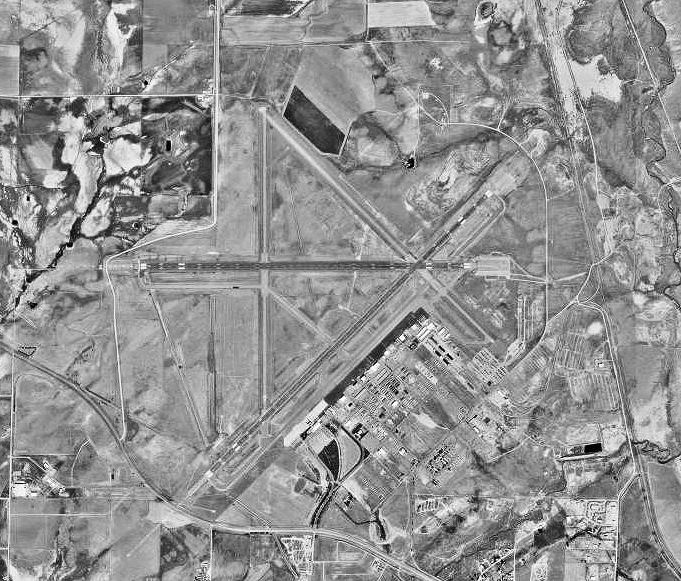
Coordinates: 42°54′29″N 106°27′52″W / 42.90806°N 106.46444°W Casper/Natrona County International Airport (IATA: CPR, ICAO: KCPR, FAA LID: CPR) is a county-owned public-use airport located 7 miles (11 km) northwest of the central business district of Casper, a city in Natrona County, Wyoming, United States. The airport is governed by a Board of Trustees consisting of 5 members each serving a 5 year term. Prior to being renamed on December 19, 2007, the airport was known as Natrona County International Airport. Regularly scheduled passenger service at the airport is offered by SkyWest Airlines for Delta Air Lines, Mesa Airlines [ends April 30, 2009] and SkyWest Airlines for United Airlines, and Allegiant Air. In addition, occasional charter flights (know as "casino or gamblers flights") to Laughlin or Wendover, Nevada are offered. In July 2004, the airport facilities were renovated. As part of the remodel, TSA baggage screening was moved from in front of the ticket counters to the area behind them. In addition, the rental car counters were moved to an area right next to baggage claim. Also the upper level of the gate area, once used for jet flights at the airport, was transformed into a viewing station for incoming or outgoing planes. Since early 2008 the airport has been in talks with the carriers to increase capacity to the region. This is due in part to the 5.8% increase in the Natrona County population between the years 2000-2006 and a 1.8% growth rate for 2006 alone. Some of the capacity will be provided by larger equipment. On April 8 of 2008, SkyWest Airlines will begin operating its Delta Connection flights to Salt Lake City using the Canadair CRJ-200 aircraft, instead of the smaller Embraer EMB-120. The Canadian-built CRJ has the capacity for 50 passengers, while the Brazilian built EMB-120 has room for 30 passengers, although due to federally mandated minimum passenger weight calculations, the latter many times only carries 25 or 26 passengers. In addition on June 5, 2008 United Airlines began offering nonstop service from Casper to its Chicago hub, although its flight was recently discontinued. Also as of September 19, 2008 Allegiant Air is offering twice weekly flight to Las Vegas on Mondays and Fridays. Service n this route was recently changed to Sundays and Thursdays. In addition to the airport successfully getting airlines to increase capacity it has also been working with the airlines to bring fares down. A recent leakage study shows that many travelers are driving to Denver, CO where they are finding lower airfares at Denver International Airport. The information from this study was then passed on to the airlines in the hopes that they might decrease their fares. It appears that it worked, as data obtained on May 20, 2008 shows that airfares decreased significantly from the previous week. Located near the airport is the NCIA Business Park that houses over 35 business that ranges from manufacturing to aviation. Facilities and aircraftCasper/Natrona County International Airport covers an area of 5,131 acres (2,076 ha) which contains four asphalt paved runways. The primary air carrier runways are 3/21 measuring 10,165 x 150 ft (3,098 x 46 m) and 8/26 measuring 8,679 x 150 ft (2,645 x 46 m). The general aviation runways are 17/35 measuring 7,211 x 60 ft (2,198 x 18 m) and 12/30 measuring 6,489 x 60 ft (1,978 x 18 m). For the 12-month period ending May 31, 2006, the airport had 47,210 aircraft operations, an average of 129 per day: 60% general aviation, 24% scheduled commercial, 14% air taxi and 1% military. There are 90 aircraft based at this airport: 51% single-engine, 34% multi-engine, 9% jet and 6% helicopter. Airlines and destinations
Cargo
Ground transportationTaxi service and car rental agencies are available at the airport. Several local hotels offer free shuttle service to and from the airport and their premises. HistoryThe airport started as the Casper Army Airfield in September 1942. The wartime airfield consisted of four asphalt hard surfaced runways; varying in length between 8900' and 8600' (N/S; NE/SW; E/W; NW/SE). Casper AAF was assigned to Second Air Force, with a mission of being a heavy bomber (B-17; B-24) replacement training unit, with the 331st Bombardment Group being the training unit with four squadrons (461st, 462d, 463d and 464th Bombardment) performing training of personnel in heavy bomber operations. The 331st Combat Crew Training School provided the ground instruction. Once the personnel completed the training course, they were sent to various combat units overseas as replacement personnel. The 331st was converted to a Very Heavy (B-29) group in July 1944 and began training for deployment to Twentieth Air Force in the Pacific. The 211th Army Air Force Base Unit took control of the airfield. Casper AAF became part of Air Transport Command, as a transit station for WASP pilots ferrying combat aircraft across the United States. The airfield was inactivated in March 1945, and on 30 September was turned over to the Army Corps of Engineers as surplus. The airfield was converted to civil control by the War Assets Administration in the late 1940s, and in 1949 the former Army airfield become the Natrona County Municipal Airport. Before that the airport was located in what is now the town of Bar Nun and what are now the streets were the runways at the airport. Natrona County International Airport is now home to the Wyoming Veterans' Memorial Museum, a World War II museum located at the its business park. The above content comes from Wikipedia and is published under free licenses – click here to read more.
Location & QuickFacts
Owner & Manager
Airport Operations and Facilities
Airport Communications
Airport Services
Runway InformationRunway 03/21
Runway 08/26
Runway 12/30
Runway 17/35
Radio Navigation Aids
Remarks
Images and information placed above are from We thank them for the data!
We don't guarantee the information is fresh and accurate. The data may
be wrong or outdated.
|
|||||||||||||||||||||||||||||||||||||||||||||||||||||||||||||||||||||||||||||||||||||||||||||||||||||||||||||||||||||||||||||||||||||||||||||||||||||||||||||||||||||||||||||||||||||||||||||||||||||||||||||||||||||||||||||||||||||||||||||||||||||||||||||||||||||||||||||||||||||||||||||||||||||||||||||||||||||||||||||||||||||||||||||||||||||||||||||||||||||||||||||||||||||||||||||||||||||||||||||||||||||||||||||

 |
|
Copyright 2004-2026 © by Airports-Worldwide.com, Vyshenskoho st. 36, Lviv 79010, Ukraine Legal Disclaimer |