 |
|
Coordinates: 41°18′43″N 105°40′30″W / 41.31194°N 105.675°W / 41.31194; -105.675
| Laramie Regional Airport |
 |
| IATA: LAR – ICAO: KLAR – FAA LID: LAR |
| Summary |
| Airport type |
Public |
| Owner |
Laramie Regional Airport Board |
| Serves |
Laramie, Wyoming |
| Elevation AMSL |
7,284 ft / 2,220 m |
| Website |
www.LaramieAirport.com |
| Runways |
| Direction |
Length |
Surface |
| ft |
m |
| 3/21 |
8,500 |
2,591 |
Asphalt |
| 12/30 |
6,300 |
1,920 |
Asphalt |
| Statistics (2007) |
| Aircraft operations |
11,140 |
| Based aircraft |
38 |
| Sources: airport web site and FAA |
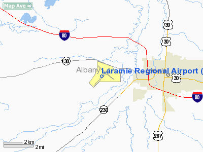
Laramie Regional Airport (IATA: LAR, ICAO: KLAR, FAA LID: LAR) is a public airport located three miles (5 km) west of the central business district of Laramie, a city in Albany County, Wyoming, United States. It is owned by the Laramie Regional Airport Board.
The area is home to many local businesses and both the University of Wyoming and the Wyoming Technical Institute. The airport has commercial flights to Denver, Colorado, but these flights account for less than one percent of all traffic at the airport; most planes that use the airport are privately-owned. The airport also plays an important fire fighting role. Commercial airline service is subsidized by the Essential Air Service program. History
From its creation in 1934 up until 1992, the airport was named Brees Field, after United States Army general Herbert J. Brees. In order to receive B-24 Bombers, the runways were first paved in 1944. This also made possible commercial service, which started in 1945. In 1959, the terminal building was built.
Facilities and aircraft
Laramie Regional Airport covers an area of 1,580 acres (639 ha) which contains two asphalt paved runways: 3/21 measuring 8,500 x 150 ft (2,591 x 46 m) and 12/30 measuring 6,300 x 100 ft (1,920 x 30 m).
For the 12-month period ending August 31, 2007, the airport had 11,140 aircraft operations, an average of 30 per day: 68% general aviation, 29% air taxi, 3% military and <1% scheduled commercial. There are 38 aircraft based at this airport: 74% single-engine, 21% multi-engine, 3% jet and 3% ultralight.
Airlines and destinations
| Airlines |
Destinations |
| Great Lakes Airlines |
Denver, Worland |
The above content comes from Wikipedia and is published under free licenses – click here to read more.
Location & QuickFacts
| FAA Information Effective: | 2008-09-25 |
| Airport Identifier: | LAR |
| Airport Status: | Operational |
| Longitude/Latitude: | 105-40-30.0000W/41-18-43.4000N
-105.675000/41.312056 (Estimated) |
| Elevation: | 7284 ft / 2220.16 m (Surveyed) |
| Land: | 1580 acres |
| From nearest city: | 3 nautical miles W of Laramie, WY |
| Location: | Albany County, WY |
| Magnetic Variation: | 13E (1980) |
Owner & Manager
| Ownership: | Publicly owned |
| Owner: | Laramie Regional Airport Board |
| Address: | 555 General Breese Rd
Laramie, WY 82070 |
| Phone number: | 307-742-4164 |
| Manager: | Jack Skinner |
| Address: | 555 General Brees Rd
Laramie, WY 82070 |
| Phone number: | 307-742-4164 |
Airport Operations and Facilities
| Airport Use: | Open to public |
| Wind indicator: | Yes |
| Segmented Circle: | Yes |
| Control Tower: | No |
| Lighting Schedule: | DUSK-DAWN
ACTVT MIRL RYS 03/21 & 12/30, PAPI RYS 03 & 12, VASI RYS 21 & 30, REIL RYS 03, 21 & 12 AND ODALS RY 30 - CTAF. |
| Beacon Color: | Clear-Green (lighted land airport) |
| Landing fee charge: | No |
| Sectional chart: | Cheyenne |
| Region: | ANM - Northwest Mountain |
| Traffic Pattern Alt: | 800 ft |
| Boundary ARTCC: | ZDV - Denver |
| Tie-in FSS: | CPR - Casper |
| FSS Toll Free: | 1-800-WX-BRIEF |
| NOTAMs Facility: | LAR (NOTAM-d service avaliable) |
| Certification type/date: | II A S 05/197
PPR FOR UNSKED ACR OPNS WITH MORE THAN 30 PSGR SEATS CALL AMGR 307-742-4164. |
| Federal Agreements: | NGY3 |
Airport Communications
| CTAF: | 123.050 |
| Unicom: | 123.050 |
Airport Services
| Fuel available: | 100LLA |
| Airframe Repair: | MINOR |
| Bulk Oxygen: | LOW |
Runway Information
Runway 03/21
| Dimension: | 8500 x 150 ft / 2590.8 x 45.7 m |
| Surface: | ASPH, Good Condition |
| Surface Treatment: | Porous Friction Course |
| Weight Limit: | Single wheel: 86000 lbs.
Dual wheel: 105000 lbs.
Dual tandem wheel: 160000 lbs. |
| Edge Lights: | Medium |
| |
Runway 03 |
Runway 21 |
| Longitude: | 105-41-14.6258W | 105-39-55.0666W |
| Latitude: | 41-18-09.7108N | 41-19-08.5074N |
| Elevation: | 7283.00 ft | 7272.00 ft |
| Alignment: | 46 | 127 |
| Traffic Pattern: | Left | Left |
| Markings: | Non-precision instrument, Good Condition | Non-precision instrument, Good Condition |
| Crossing Height: | 32.00 ft | 53.00 ft |
| VASI: | 4-light PAPI on left side | 4-box on left side |
| Visual Glide Angle: | 3.00° | 3.00° |
| Runway End Identifier: | Yes | Yes |
|
Runway 12/30
| Dimension: | 6300 x 100 ft / 1920.2 x 30.5 m |
| Surface: | ASPH, Good Condition |
| Surface Treatment: | Porous Friction Course |
| Weight Limit: | Single wheel: 86000 lbs.
Dual wheel: 105000 lbs.
Dual tandem wheel: 160000 lbs. |
| Edge Lights: | Medium |
| |
Runway 12 |
Runway 30 |
| Longitude: | 105-40-52.7514W | 105-39-53.9292W |
| Latitude: | 41-19-11.0342N | 41-18-27.3546N |
| Elevation: | 7273.00 ft | 7275.00 ft |
| Alignment: | 127 | 127 |
| Traffic Pattern: | Left | Left |
| Markings: | Non-precision instrument, Good Condition | Non-precision instrument, Good Condition |
| Crossing Height: | 43.00 ft | 41.00 ft |
| VASI: | 4-light PAPI on left side | 4-box on left side |
| Visual Glide Angle: | 3.00° | 3.00° |
| Approach lights: | | ODALS |
| Runway End Identifier: | Yes | |
|
Radio Navigation Aids
| ID |
Type |
Name |
Ch |
Freq |
Var |
Dist |
| MBW | VOR/DME | Medicine Bow | 053X | 111.60 | 14E | 35.3 nm |
| LAR | VORTAC | Laramie | 123X | 117.60 | 14E | 2.6 nm |
| CYS | VORTAC | Cheyenne | 078X | 113.10 | 13E | 41.2 nm |
Images and information placed above are from
http://www.airport-data.com/airport/LAR/
We thank them for the data!
| General Info
|
| Country |
United States
|
| State |
WYOMING
|
| FAA ID |
LAR
|
| Latitude |
41-18-43.400N
|
| Longitude |
105-40-30.000W
|
| Elevation |
7284 feet
|
| Near City |
LARAMIE
|
We don't guarantee the information is fresh and accurate. The data may
be wrong or outdated.
For more up-to-date information please refer to other sources.
|
|


