 |
|
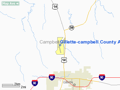
Gillette-campbell County Airport |
| Gillette-Campbell County Airport |
| IATA: GCC – ICAO: KGCC – FAA LID: GCC |
| Summary |
| Airport type |
Public |
| Operator |
Campbell County Airport Board |
| Location |
Gillette, Wyoming |
| Elevation AMSL |
4,365 ft / 1,331 m |
| Coordinates |
44°20′56″N 105°32′22″W / 44.34889°N 105.53944°W / 44.34889; -105.53944Coordinates: 44°20′56″N 105°32′22″W / 44.34889°N 105.53944°W / 44.34889; -105.53944 |
| Runways |
| Direction |
Length |
Surface |
| ft |
m |
| 16/34 |
7,500 |
2,286 |
Concrete |
| 3/21 |
5,803 |
1,769 |
Concrete |
Gillette-Campbell County Airport (IATA: GCC, ICAO: KGCC, FAA LID: GCC) is a controlled, public airport located four miles (6.4 km) northwest of Gillette, in Campbell County, Wyoming, USA. It is mainly used for general aviation, but is also served by Great Lakes Aviation for United Airlines and Frontier Airlines and one commercial cargo airline. On March 31, 2008 Mesa Airlines is starting service to Denver for United Airlines. In addition the airport is working with SkyWest Airlines to have them offer service for Delta Air Lines to Salt Lake City. The airport has secured a state funded grant that would act as a revenue guarantee for the airline. Airlines and destinations
| Airlines |
Destinations |
| Delta Connection operated by SkyWest Airlines |
Salt Lake City |
| Great Lakes Airlines |
Billings, Denver, Miles City |
| United Express operated by SkyWest Airlines |
Denver |
Charter carriers
The above content comes from Wikipedia and is published under free licenses – click here to read more.
Location & QuickFacts
| FAA Information Effective: | 2008-09-25 |
| Airport Identifier: | GCC |
| Airport Status: | Operational |
| Longitude/Latitude: | 105-32-21.7000W/44-20-56.1000N
-105.539361/44.348917 (Estimated) |
| Elevation: | 4365 ft / 1330.45 m (Surveyed) |
| Land: | 759 acres |
| From nearest city: | 4 nautical miles NW of Gillette, WY |
| Location: | Campbell County, WY |
| Magnetic Variation: | 12E (1990) |
Owner & Manager
| Ownership: | Publicly owned |
| Owner: | Campbell Co |
| Address: | 2000 Airport Road Suite 108
Gillette, WY 82716 |
| Phone number: | 307-686-1042 |
| Manager: | Jay Lundell |
| Address: | 2000 Airport Road Suite 108
Gillette, WY 82716 |
| Phone number: | 307-686-1042
AFTER HOURS CONTACT NUMBER (PAGER) 307-686-4562. |
Airport Operations and Facilities
| Airport Use: | Open to public |
| Wind indicator: | Yes |
| Segmented Circle: | Yes |
| Control Tower: | Yes |
| Lighting Schedule: | DUSK-DAWN
WHEN ATCT CLSD ACTVT HIRL RY 16/34, MIRL RY 03/21, MALSR RY 34, PAPI RYS 03, 21, 16 & 34 - CTAF. WHEN ATCT CLSD SEQUENCE FLASHERS RY 34 AVBL ON HIGH SETTING ONLY, REIL RYS 03, 21 & 16 NOT AVBL. |
| Beacon Color: | Clear-Green (lighted land airport) |
| Landing fee charge: | No |
| Sectional chart: | Cheyenne |
| Region: | ANM - Northwest Mountain |
| Boundary ARTCC: | ZDV - Denver |
| Tie-in FSS: | CPR - Casper |
| FSS on Airport: | No |
| FSS Toll Free: | 1-800-WX-BRIEF |
| NOTAMs Facility: | GCC (NOTAM-d service avaliable) |
| Certification type/date: | II A S 09/200
PPR UNSKED ACR OPNS WITH MORE THAN 30 PSGR SEATS CALL AMGR 307-686-1042. |
| Federal Agreements: | NGY |
Airport Communications
| CTAF: | 118.500 |
| Unicom: | 122.950 |
Airport Services
| Fuel available: | 100LLA
24 HR SELF SERVICE CREDIT CARD FUEL AVBL. |
| Airframe Repair: | MAJOR |
| Power Plant Repair: | MAJOR |
| Bottled Oxygen: | NONE |
| Bulk Oxygen: | HIGH/LOW |
Runway Information
Runway 03/21
| Dimension: | 5803 x 75 ft / 1768.8 x 22.9 m |
| Surface: | CONC, Good Condition |
| Surface Treatment: | Saw-cut or plastic Grooved |
| Weight Limit: | Single wheel: 40000 lbs. |
| Edge Lights: | Medium |
| |
Runway 03 |
Runway 21 |
| Longitude: | 105-32-37.3463W | 105-31-47.8252W |
| Latitude: | 44-20-42.8996N | 44-21-27.8469N |
| Elevation: | 4343.00 ft | 4316.00 ft |
| Alignment: | 38 | 127 |
| Traffic Pattern: | Left | Left |
| Markings: | Non-precision instrument, Good Condition | Non-precision instrument, Good Condition |
| Crossing Height: | 41.00 ft | 39.00 ft |
| VASI: | 4-light PAPI on left side | 4-light PAPI on left side |
| Visual Glide Angle: | 4.00° | 4.00° |
| Runway End Identifier: | Yes | Yes |
|
Runway 16/34
| Dimension: | 7500 x 150 ft / 2286.0 x 45.7 m |
| Surface: | CONC, Good Condition |
| Surface Treatment: | Saw-cut or plastic Grooved |
| Weight Limit: | Single wheel: 60000 lbs.
Dual wheel: 110000 lbs.
Dual tandem wheel: 160000 lbs. |
| Edge Lights: | High |
| |
Runway 16 |
Runway 34 |
| Longitude: | 105-32-38.0501W | 105-32-19.5373W |
| Latitude: | 44-21-25.2939N | 44-20-12.4421N |
| Elevation: | 4337.00 ft | 4364.00 ft |
| Alignment: | 127 | 127 |
| ILS Type: | | ILS/DME
|
| Traffic Pattern: | Left | Left |
| Markings: | Precision instrument, Good Condition | Precision instrument, Good Condition |
| Crossing Height: | 43.00 ft | 56.00 ft |
| VASI: | 4-light PAPI on left side | 4-light PAPI on left side |
| Visual Glide Angle: | 3.17° | 3.20° |
| Approach lights: | | MALSR |
| Runway End Identifier: | Yes | |
| Obstruction: | 56 ft road, 1600.0 ft from runway, 25:1 slope to clear | 312 ft pline, 9732.0 ft from runway, 1351 ft right of centerline, 30:1 slope to clear |
|
Radio Navigation Aids
| ID |
Type |
Name |
Ch |
Freq |
Var |
Dist |
| GC | NDB | Deryk | | 380.00 | 12E | 4.7 nm |
| GCC | VOR/DME | Gillette | 093X | 114.60 | 12E | 0.2 nm |
| CZI | VOR/DME | Crazy Woman | 120X | 117.30 | 13E | 44.0 nm |
Remarks
- MINING/BLASTING OPNS 1/2 MILE NE AER 21 DURG DALGT HRS CTC ATCT.
- PORTIONS OF TWY C NOT VSBL FM ATCT.
- MIGRATORY WATERFOWL INVOF ARPT.
- ESTABLISHED PRIOR TO 1959.
Images and information placed above are from
http://www.airport-data.com/airport/GCC/
We thank them for the data!
| General Info
|
| Country |
United States
|
| State |
WYOMING
|
| FAA ID |
GCC
|
| Latitude |
44-20-56.100N
|
| Longitude |
105-32-21.700W
|
| Elevation |
4365 feet
|
| Near City |
GILLETTE
|
We don't guarantee the information is fresh and accurate. The data may
be wrong or outdated.
For more up-to-date information please refer to other sources.
|
|


