 |
|
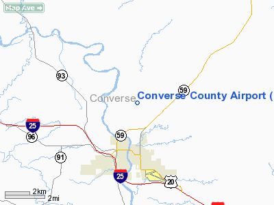
| Converse County Airport |
| IATA: DGW – ICAO: KDGW – FAA LID: DGW |
| Summary |
| Airport type |
Public |
| Owner |
Converse County |
| Serves |
Douglas, Wyoming |
| Elevation AMSL |
4,933 ft / 1,504 m |
| Coordinates |
42°47′50″N 105°23′09″W / 42.79722°N 105.38583°W / 42.79722; -105.38583 |
| Runways |
| Direction |
Length |
Surface |
| ft |
m |
| 11/29 |
6,534 |
1,992 |
Asphalt |
| 5/23 |
4,760 |
1,451 |
Asphalt |
| Helipads |
| Number |
Length |
Surface |
| ft |
m |
| H1 |
60 |
18 |
Asphalt |
| H2 |
60 |
18 |
Asphalt |
| Statistics (2008) |
| Aircraft operations |
5,475 |
| Based aircraft |
40 |
| Source: Federal Aviation Administration |
Converse County Airport (IATA: DGW, ICAO: KDGW, FAA LID: DGW) is a county-owned public-use airport in Converse County, Wyoming, United States. It is located three nautical miles (6 km) north of the central business district of Douglas, Wyoming.
Facilities and aircraft
Converse County Airport covers an area of 494 acres (200 ha) at an elevation of 4,933 feet (1,504 m) above mean sea level. It has two asphalt paved runways: 11/29 is 6,534 by 100 feet (1,992 x 30 m) and 5/23 is 4,760 by 75 feet (1,451 x 23 m). It also has two helipads designed H1 and H2, each of which measures 60 by 60 feet (18 x 18 m).
For the 12-month period ending May 30, 2008, the airport had 5,475 aircraft operations, an average of 15 per day: 98% general aviation, 2% air taxi and <1% military. At that time there were 40 aircraft based at this airport: 35 single-engine, 3 multi-engine, 1 jet and 1 ultralight.
The above content comes from Wikipedia and is published under free licenses – click here to read more.
Location & QuickFacts
| FAA Information Effective: | 2008-09-25 |
| Airport Identifier: | DGW |
| Airport Status: | Operational |
| Longitude/Latitude: | 105-23-08.9830W/42-47-49.8280N
-105.385829/42.797174 (Estimated) |
| Elevation: | 4932 ft / 1503.27 m (Surveyed) |
| Land: | 494 acres |
| From nearest city: | 3 nautical miles N of Douglas, WY |
| Location: | Converse County, WY |
| Magnetic Variation: | 11E (2005) |
Owner & Manager
| Ownership: | Publicly owned |
| Owner: | Converse County |
| Address: | Po Box 774
Douglas, WY 82633 |
| Phone number: | 307-358-4924 |
| Manager: | Steve Good |
| Address: | P O Box 774
Douglas, WY 82633 |
| Phone number: | 307-358-3527 |
Airport Operations and Facilities
| Airport Use: | Open to public |
| Wind indicator: | Yes |
| Segmented Circle: | Yes |
| Control Tower: | No |
| Lighting Schedule: | DUSK-DAWN
MIRL RYS 11/29 & 05/23 PRESET ON LOW INTENSITY; TO INCREASE INTENSITY AND ACTVT REIL RY 28 - CTAF. PAPI RYS 11, 23, & 29 OPR CONTINUOUSLY. |
| Beacon Color: | Clear-Green (lighted land airport) |
| Landing fee charge: | No |
| Sectional chart: | Cheyenne |
| Region: | ANM - Northwest Mountain |
| Boundary ARTCC: | ZDV - Denver |
| Tie-in FSS: | CPR - Casper |
| FSS on Airport: | No |
| FSS Toll Free: | 1-800-WX-BRIEF |
| NOTAMs Facility: | DGW (NOTAM-d service avaliable) |
| Federal Agreements: | NGY |
Airport Communications
| CTAF: | 122.800 |
| Unicom: | 122.800 |
Airport Services
| Fuel available: | 100LLA |
| Airframe Repair: | MAJOR |
| Power Plant Repair: | MAJOR |
| Bottled Oxygen: | NONE |
| Bulk Oxygen: | NONE |
Runway Information
Runway 05/23
| Dimension: | 4760 x 75 ft / 1450.8 x 22.9 m |
| Surface: | ASPH, Good Condition |
| Weight Limit: | Single wheel: 12500 lbs. |
| Edge Lights: | Medium |
| |
Runway 05 |
Runway 23 |
| Longitude: | 105-23-54.7700W | 105-22-56.0790W |
| Latitude: | 42-47-53.1740N | 42-48-11.6500N |
| Elevation: | 4898.00 ft | 4911.00 ft |
| Alignment: | 67 | 127 |
| Traffic Pattern: | Left | Left |
| Markings: | Basic, Good Condition | Basic, Good Condition |
| Crossing Height: | 0.00 ft | 46.00 ft |
| VASI: | | 2-light PAPI on left side |
| Visual Glide Angle: | 0.00° | 3.00° |
| Obstruction: | , 50:1 slope to clear | 116 ft hill, 2925.0 ft from runway, 175 ft right of centerline, 23:1 slope to clear |
|
Runway 11/29
| Dimension: | 6532 x 100 ft / 1991.0 x 30.5 m |
| Surface: | ASPH, Good Condition |
| Edge Lights: | Medium |
| |
Runway 11 |
Runway 29 |
| Longitude: | 105-23-35.6350W | 105-22-18.2040W |
| Latitude: | 42-47-55.7100N | 42-47-25.5690N |
| Elevation: | 4909.00 ft | 4932.00 ft |
| Alignment: | 118 | 127 |
| Traffic Pattern: | Left | Left |
| Markings: | Non-precision instrument, Good Condition | Non-precision instrument, Good Condition |
| Crossing Height: | 31.00 ft | 41.00 ft |
| VASI: | 2-light PAPI on left side | 2-light PAPI on left side |
| Visual Glide Angle: | 3.00° | 3.00° |
| Runway End Identifier: | | Yes |
|
Helipad H1
| Dimension: | 60 x 60 ft / 18.3 x 18.3 m |
| Surface: | ASPH, Fair Condition |
| |
Runway H1 |
Runway |
| Traffic Pattern: | Left | Left |
| Markings: | Basic, Good Condition | , |
|
Helipad H2
| Dimension: | 60 x 60 ft / 18.3 x 18.3 m |
| Surface: | ASPH, Fair Condition |
| |
Runway H2 |
Runway |
| Traffic Pattern: | Left | Left |
| Markings: | Basic, Good Condition | , |
|
Radio Navigation Aids
| ID |
Type |
Name |
Ch |
Freq |
Var |
Dist |
| GYZ | NDB | Camp Guernsey | | 280.00 | 11E | 44.8 nm |
| IIP | VOR/DME | Hipsher | 023X | 108.60 | 12E | 10.1 nm |
| DDY | VORTAC | Muddy Mountain | 109X | 116.20 | 12E | 43.0 nm |
Remarks
- WILDLIFE ON & INVOF ARPT.
- RETRO-REFLECTIVE MARKERS ALONG ALL TAXIWAYS
Images and information placed above are from
http://www.airport-data.com/airport/DGW/
We thank them for the data!
| General Info
|
| Country |
United States
|
| State |
WYOMING
|
| FAA ID |
DGW
|
| Latitude |
42-47-50.100N
|
| Longitude |
105-23-08.650W
|
| Elevation |
4929 feet
|
| Near City |
DOUGLAS
|
We don't guarantee the information is fresh and accurate. The data may
be wrong or outdated.
For more up-to-date information please refer to other sources.
|
|


