 |
|
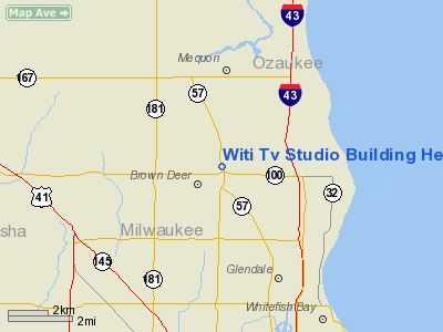
Witi Tv Studio Building Heliport |
Location & QuickFacts
| FAA Information Effective: | 2008-09-25 |
| Airport Identifier: | 74WI |
| Airport Status: | Operational |
| Longitude/Latitude: | 087-57-48.3160W/43-10-52.0310N
-87.963421/43.181120 (Estimated) |
| Elevation: | 660 ft / 201.17 m (Estimated) |
| Land: | 0 acres |
| From nearest city: | 0 nautical miles N of Brown Deer, WI |
| Location: | Milwaukee County, WI |
| Magnetic Variation: | 01W (1985) |
Owner & Manager
| Ownership: | Privately owned |
| Owner: | Witi Tv Inc |
| Address: | 9001 North Green Bay Road
Brown Deer, WI 53217 |
| Phone number: | 414-355-6666 |
| Manager: | Andrew P. Potos |
| Address: | 9001 North Green Bay Road
Brown Deer, WI 53217 |
| Phone number: | 414-355-6666 |
Airport Operations and Facilities
| Airport Use: | Private |
| Wind indicator: | No |
| Segmented Circle: | No |
| Control Tower: | No |
| Landing fee charge: | No |
| Sectional chart: | Chicago |
| Region: | AGL - Great Lakes |
| Boundary ARTCC: | ZAU - Chicago |
| Tie-in FSS: | GRB - Green Bay |
| FSS on Airport: | No |
| FSS Toll Free: | 1-800-WX-BRIEF |
Runway Information
Helipad H1
| Dimension: | 100 x 100 ft / 30.5 x 30.5 m |
| Surface: | ASPH, |
| |
Runway H1 |
Runway |
| Traffic Pattern: | Left | Left |
|
Radio Navigation Aids
| ID |
Type |
Name |
Ch |
Freq |
Var |
Dist |
| BL | NDB | Yanks | | 260.00 | 02W | 8.2 nm |
| UES | NDB | Waukesha | | 359.00 | 01W | 14.5 nm |
| LLE | NDB | Kettle Moraine | | 329.00 | 01W | 16.3 nm |
| GM | NDB | Teels | | 242.00 | 02W | 16.7 nm |
| HXF | NDB | Hartford | | 200.00 | 00E | 21.4 nm |
| RA | NDB | Paser | | 206.00 | 00E | 30.1 nm |
| RYV | NDB | Rock River | | 371.00 | 01W | 33.4 nm |
| UNU | NDB | Juneau | | 344.00 | 01W | 35.6 nm |
| LVV | NDB | Lake Lawn | | 404.00 | 00W | 40.1 nm |
| BJB | VOR | West Bend | | 109.80 | 01W | 16.1 nm |
| LJT | VOR/DME | Timmerman | 072X | 112.50 | 02W | 5.4 nm |
| HRK | VOR/DME | Horlick | 124X | 117.70 | 02W | 26.0 nm |
| BUU | VOR/DME | Burbun | 092X | 114.50 | 01W | 33.1 nm |
| ENW | VOR/DME | Kenosha | 029X | 109.20 | 02W | 35.0 nm |
| FAH | VOR/DME | Falls | 37X | 110.00 | 02W | 35.7 nm |
| BAE | VORTAC | Badger | 111X | 116.40 | 02E | 14.6 nm |
| MKE | VOT | Milwaukee | | 109.00 | | 14.3 nm |
Remarks
- (E111-1) THE TAKEOFF/LANDING AREA IS APPROPRIATELY MARKED/LGTD; A NON OBSTRUCTING WIND INDICATOR IS MAINTAINED ADJACENT TO THE TAKEOFF/LANDING AREA.
- ALL APCH/DEPARTURE ROUTE HELICOPTERS OPERATION ARE CONDUCTED IN AN AREA FROM 050 DEG CLOCKWISE TO 110 DEG AND FROM 280 DEG CLOCKWISE TO 340 DEG USING THE TOUCHDOWN PAD AS THE CENTER OF A COMPASS ROSE.
Images and information placed above are from
http://www.airport-data.com/airport/74WI/
We thank them for the data!
| General Info
|
| Country |
United States
|
| State |
WISCONSIN
|
| FAA ID |
74WI
|
| Latitude |
43-10-52.031N
|
| Longitude |
087-57-48.316W
|
| Elevation |
660 feet
|
| Near City |
BROWN DEER
|
We don't guarantee the information is fresh and accurate. The data may
be wrong or outdated.
For more up-to-date information please refer to other sources.
|
|


