 |
|
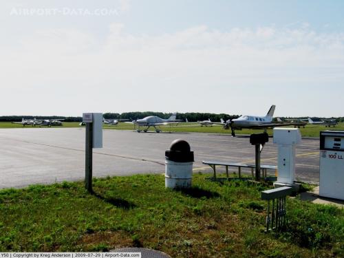 |
(Click on the photo to enlarge) |
Location & QuickFacts
| FAA Information Effective: | 2008-09-25 |
| Airport Identifier: | Y50 |
| Airport Status: | Operational |
| Longitude/Latitude: | 089-18-16.1530W/44-02-29.8520N
-89.304487/44.041626 (Estimated) |
| Elevation: | 859 ft / 261.82 m (Surveyed) |
| Land: | 353 acres |
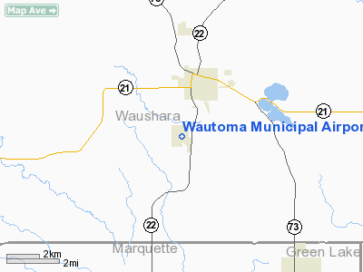
| From nearest city: | 2 nautical miles SW of Wautoma, WI |
| Location: | Waushara County, WI |
| Magnetic Variation: | 02W (2000) |
Owner & Manager
| Ownership: | Publicly owned |
| Owner: | City Of Wautoma |
| Address: | City Hall
Wautoma, WI 54982 |
| Phone number: | 920-787-4044 |
| Manager: | Dennis Winter |
| Address: | W8471 Cottonville Drive
Wautoma, WI 54982 |
| Phone number: | 920-787-3030 |
Airport Operations and Facilities
| Airport Use: | Open to public |
| Wind indicator: | Yes |
| Segmented Circle: | Yes |
| Control Tower: | No |
| Lighting Schedule: | DUSK-DAWN
MIRL RY 13/31 PRESET LOW INTST; TO INCR INTST ACTVT - CTAF. |
| Beacon Color: | Clear-Green (lighted land airport) |
| Landing fee charge: | No |
| Sectional chart: | Green Bay |
| Region: | AGL - Great Lakes |
| Boundary ARTCC: | ZAU - Chicago |
| Tie-in FSS: | GRB - Green Bay |
| FSS on Airport: | No |
| FSS Toll Free: | 1-800-WX-BRIEF |
| NOTAMs Facility: | GRB (NOTAM-d service avaliable) |
| Federal Agreements: | N1 |
Airport Communications
| CTAF: | 122.800 |
| Unicom: | 122.800 |
Airport Services
| Fuel available: | 100LL
FOR FUEL AFT HRS CALL 920-787-2059. |
| Airframe Repair: | MAJOR |
| Power Plant Repair: | MAJOR |
| Bottled Oxygen: | NONE |
| Bulk Oxygen: | NONE |
Runway Information
Runway 05/23
| Dimension: | 1190 x 35 ft / 362.7 x 10.7 m |
| Surface: | ASPH, Fair Condition |
| |
Runway 05 |
Runway 23 |
| Traffic Pattern: | Left | Left |
| Obstruction: | 64 ft trees, 2200.0 ft from runway, 100 ft left of centerline, 31:1 slope to clear | 55 ft trees, 1300.0 ft from runway, 250 ft right of centerline, 20:1 slope to clear |
|
Runway 08/26
| Dimension: | 2280 x 150 ft / 694.9 x 45.7 m |
| Surface: | TURF, Good Condition |
| |
Runway 08 |
Runway 26 |
| Longitude: | 089-18-42.7500W | 089-18-11.8000W |
| Latitude: | 44-02-41.9200N | 44-02-44.8600N |
| Elevation: | 858.00 ft | 856.00 ft |
| Alignment: | 82 | 127 |
| Traffic Pattern: | Left | Left |
| Markings: | None,
RWY 08 /26 ENDS MKD WITH WHITE MARKERS. | None, |
| Runway End Identifier: | No | No |
| Centerline Lights: | No | No |
| Touchdown Lights: | No | No |
| Obstruction: | 58 ft trees, 1050.0 ft from runway, 18:1 slope to clear | 59 ft trees, 1850.0 ft from runway, 200 ft right of centerline, 31:1 slope to clear |
|
Runway 13/31
| Dimension: | 3300 x 60 ft / 1005.8 x 18.3 m |
| Surface: | ASPH, Fair Condition |
| Weight Limit: | Single wheel: 12500 lbs. |
| Edge Lights: | Medium |
| |
Runway 13 |
Runway 31 |
| Longitude: | 089-18-33.0020W | 089-17-59.3040W |
| Latitude: | 44-02-40.7030N | 44-02-19.0020N |
| Elevation: | 859.00 ft | 856.00 ft |
| Alignment: | 127 | 127 |
| Traffic Pattern: | Left | Left |
| Markings: | Non-precision instrument, Fair Condition | Non-precision instrument, Fair Condition |
| Runway End Identifier: | No | No |
| Centerline Lights: | No | No |
| Touchdown Lights: | No | No |
| Obstruction: | 53 ft trees, 1500.0 ft from runway, 300 ft left of centerline, 24:1 slope to clear | 52 ft tree, 1350.0 ft from runway, 300 ft left of centerline, 22:1 slope to clear |
|
Radio Navigation Aids
| ID |
Type |
Name |
Ch |
Freq |
Var |
Dist |
| PCZ | NDB | Waupaca | | 382.00 | 01W | 21.4 nm |
| ISW | NDB | Wisconsin Rapids | | 215.00 | 01W | 30.1 nm |
| AQ | NDB | Kooky | | 407.00 | 02W | 40.4 nm |
| CLI | NDB | Clintonville | | 209.00 | 02W | 42.5 nm |
| UNU | NDB | Juneau | | 344.00 | 01W | 45.2 nm |
| VOK | TACAN | Volk | 041X | | 00E | 41.7 nm |
| STE | VORTAC | Stevens Point | 043X | 110.60 | 01W | 31.7 nm |
| OSH | VORTAC | Oshkosh | 055X | 111.80 | 02E | 32.5 nm |
| DLL | VORTAC | Dells | 117X | 117.00 | 03E | 35.6 nm |
| AUW | VORTAC | Wausau | 053X | 111.60 | 02E | 49.9 nm |
Remarks
- WATERFOWL AND DEER ON AND INVOF ARPT.
- ULTRALIGHT ACTIVITY ON & INVOF ARPT.
Images and information placed above are from
http://www.airport-data.com/airport/Y50/
We thank them for the data!
| General Info
|
| Country |
United States
|
| State |
WISCONSIN
|
| FAA ID |
Y50
|
| Latitude |
44-02-29.852N
|
| Longitude |
089-18-16.153W
|
| Elevation |
859 feet
|
| Near City |
WAUTOMA
|
We don't guarantee the information is fresh and accurate. The data may
be wrong or outdated.
For more up-to-date information please refer to other sources.
|
|


