 |
|
Coordinates: 44°55′34″N 089°37′36″W / 44.92611°N 89.62667°W / 44.92611; -89.62667
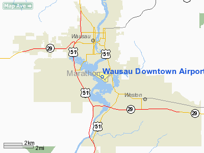
| Wausau Downtown Airport |
| IATA: AUW – ICAO: KAUW – FAA LID: AUW |
| Summary |
| Airport type |
Public |
| Owner |
City of Wausau |
| Serves |
Wausau, Wisconsin |
| Elevation AMSL |
1,201 ft / 366 m |
| Runways |
| Direction |
Length |
Surface |
| ft |
m |
| 12/30 |
5,200 |
1,585 |
Asphalt |
| 4/22 |
3,078 |
938 |
Asphalt |
| 12W/30W |
8,000 |
2,438 |
Water |
| Statistics (2006) |
| Aircraft operations |
45,000 |
| Based aircraft |
64 |
| Source: Federal Aviation Administration |
Wausau Downtown Airport (IATA: AUW, ICAO: KAUW, FAA LID: AUW) is a city-owned public-use airport located in Wausau, a city in Marathon County, Wisconsin, United States. The airport serves private aircraft and charter flights.
History
The Wausau airport was founded in 1927, and carried commercial flights until 1969, when the Central Wisconsin Airport began operations.
Facilities and aircraft
Wausau Downtown Airport covers an area of 294 acres (119 ha) which contains two asphalt paved runways: 12/30 measuring 5,200 x 100 ft. (1,585 x 30 m) and 4/22 measuring 3,078 x 100 ft. (938 x 30 m). It also has a seaplane landing area designated 12W/30W which measures 8,000 x 300 ft. (2,438 x 91 m).
For the 12-month period ending August 16, 2006, the airport had 45,000 aircraft operations, an average of 123 per day: 94% general aviation, 6% air taxi and <1% military. There are 64 aircraft based at this airport: 86% single-engine, 6% multi-engine, 6% ultralight and 2% glider.
The above content comes from Wikipedia and is published under free licenses – click here to read more.
Location & QuickFacts
| FAA Information Effective: | 2008-09-25 |
| Airport Identifier: | AUW |
| Airport Status: | Operational |
| Longitude/Latitude: | 089-37-37.2063W/44-55-34.6243N
-89.627002/44.926285 (Estimated) |
| Elevation: | 1201 ft / 366.06 m (Surveyed)
SPB RY 12W/30W LAT 44-55-31N LONG 089-37-52W & ELEV 1161E. |
| Land: | 294 acres |
| From nearest city: | 0 nautical miles S of Wausau, WI |
| Location: | Marathon County, WI |
| Magnetic Variation: | 01E (1990) |
Owner & Manager
| Ownership: | Publicly owned |
| Owner: | City Of Wausau |
| Address: | 407 Grant St.
Wausau, WI 54403 |
| Phone number: | 715-261-6740 |
| Manager: | John P Chmiel |
| Address: | 725 Woods Place
Wausau, WI 54401 |
| Phone number: | 715-845-3400 |
Airport Operations and Facilities
| Airport Use: | Open to public |
| Wind indicator: | Yes |
| Segmented Circle: | Yes |
| Control Tower: | No |
| Lighting Schedule: | DUSK-DAWN
MIRL RYS 12/30 & 04/22 PRESET LOW INTST; TO INCR INTST & ACTVT REIL RYS 12 & 30; PAPI RYS 12 & 30 - CTAF. |
| Beacon Color: | Clear-Green (lighted land airport) |
| Landing fee charge: | No |
| Sectional chart: | Green Bay |
| Region: | AGL - Great Lakes |
| Boundary ARTCC: | ZMP - Minneapolis |
| Tie-in FSS: | GRB - Green Bay |
| FSS Toll Free: | 1-800-WX-BRIEF |
| NOTAMs Facility: | AUW (NOTAM-d service avaliable) |
| Federal Agreements: | NGY |
Airport Communications
| CTAF: | 122.700 |
| Unicom: | 122.700 |
Airport Services
| Fuel available: | 100LLA MOGAS |
| Airframe Repair: | MAJOR |
| Power Plant Repair: | MAJOR |
Runway Information
Runway 04/22
| Dimension: | 3078 x 100 ft / 938.2 x 30.5 m
150 FT STWY NE END; 140 FT STWY SW END. |
| Surface: | ASPH, Good Condition |
| Weight Limit: | Single wheel: 32000 lbs.
Dual wheel: 55000 lbs.
Dual tandem wheel: 95000 lbs. |
| Edge Lights: | Medium |
| |
Runway 04 |
Runway 22 |
| Longitude: | 089-37-28.5020W | 089-36-58.5690W |
| Latitude: | 44-55-21.7970N | 44-55-43.5070N |
| Elevation: | 1190.00 ft | 1201.00 ft |
| Alignment: | 44 | 127 |
| Traffic Pattern: | Left | Left |
| Markings: | Basic, Good Condition | Basic, Good Condition |
| Runway End Identifier: | No | No |
| Centerline Lights: | No | No |
| Touchdown Lights: | No | No |
| Obstruction: | , 50:1 slope to clear | 20 ft trees, 600.0 ft from runway, 80 ft right of centerline, 20:1 slope to clear |
|
Runway 12/30
| Dimension: | 5200 x 100 ft / 1585.0 x 30.5 m
150 FT STWY NE END; 140 FT STWY SW END. |
| Surface: | ASPH, Good Condition |
| Weight Limit: | Single wheel: 45000 lbs.
Dual wheel: 80000 lbs.
Dual tandem wheel: 140000 lbs. |
| Edge Lights: | Medium |
| |
Runway 12 |
Runway 30 |
| Longitude: | 089-38-21.1621W | 089-37-21.2730W |
| Latitude: | 44-55-50.1625N | 44-55-21.4210N |
| Elevation: | 0.00 ft | 1195.00 ft |
| Alignment: | 124 | 127 |
| Traffic Pattern: | Left | Left |
| Markings: | Non-precision instrument, Good Condition | Non-precision instrument, Good Condition |
| Crossing Height: | 39.00 ft | 47.00 ft |
| VASI: | 4-light PAPI on left side | 4-light PAPI on left side |
| Visual Glide Angle: | 3.00° | 3.00° |
| Runway End Identifier: | Yes | Yes |
| Centerline Lights: | No | No |
| Touchdown Lights: | No | No |
| Obstruction: | 10 ft trees, 500.0 ft from runway, 225 ft right of centerline, 30:1 slope to clear | 25 ft trees, 900.0 ft from runway, 220 ft right of centerline, 28:1 slope to clear |
|
Runway 12W/30W
| Dimension: | 8000 x 300 ft / 2438.4 x 91.4 m
150 FT STWY NE END; 140 FT STWY SW END. |
| Surface: | WATER, |
| |
Runway 12W |
Runway 30W |
| Traffic Pattern: | Left | Left |
|
Radio Navigation Aids
| ID |
Type |
Name |
Ch |
Freq |
Var |
Dist |
| FZK | NDB | Wausau | | 243.00 | 01E | 0.1 nm |
| RRL | NDB | Merrill | | 257.00 | 01W | 16.7 nm |
| AIG | NDB | Antigo | | 347.00 | 02W | 25.9 nm |
| MFI | NDB | Marshfield | | 391.00 | 00E | 29.4 nm |
| MDZ | NDB | Medford | | 335.00 | 00E | 30.9 nm |
| ISW | NDB | Wisconsin Rapids | | 215.00 | 01W | 35.0 nm |
| CLI | NDB | Clintonville | | 209.00 | 02W | 42.4 nm |
| VIQ | NDB | Neillsville | | 368.00 | 01W | 43.9 nm |
| PCZ | NDB | Waupaca | | 382.00 | 01W | 44.3 nm |
| AUW | VORTAC | Wausau | 053X | 111.60 | 02E | 5.1 nm |
| STE | VORTAC | Stevens Point | 043X | 110.60 | 01W | 23.4 nm |
| RHI | VORTAC | Rhinelander | 029X | 109.20 | 02E | 43.1 nm |
Remarks
Images and information placed above are from
http://www.airport-data.com/airport/AUW/
We thank them for the data!
| General Info
|
| Country |
United States
|
| State |
WISCONSIN
|
| FAA ID |
AUW
|
| Latitude |
44-55-34.163N
|
| Longitude |
089-37-35.886W
|
| Elevation |
1201 feet
|
| Near City |
WAUSAU
|
We don't guarantee the information is fresh and accurate. The data may
be wrong or outdated.
For more up-to-date information please refer to other sources.
|
|


