 |
|
| Tri-County Regional Airport |
| IATA: LNR – ICAO: KLNR |
| Summary |
| Airport type |
Public |
| Operator |
Sauk, Iowa & Richland Counties |
| Location |
Lone Rock, Wisconsin |
| Elevation AMSL |
718 ft / 218.8 m |
| Coordinates |
43°12′42″N 90°10′54″W / 43.21167°N 90.18167°W / 43.21167; -90.18167Coordinates: 43°12′42″N 90°10′54″W / 43.21167°N 90.18167°W / 43.21167; -90.18167 |
| Runways |
| Direction |
Length |
Surface |
| ft |
m |
| 9/27 |
5,000 |
1,524 |
Asphalt |
| 18/36 |
1,988 |
606 |
Asphalt |
| Statistics (2007) |
| Operations |
12,000 |
| Based A/C |
41 |
| Stats for 12 months ending August 3, 2007 |
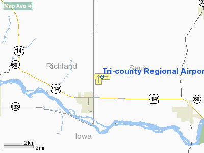
Tri-County Regional Airport (IATA: LNR, ICAO: KLNR) is a public airport located two miles (3.2 km) north of the village of Lone Rock in Sauk County, Wisconsin, USA. The airport covers 147 acres (59 ha) and has two runways. It is operated by the Wisconsin counties of Sauk, Iowa and Richland.
The above content comes from Wikipedia and is published under free licenses – click here to read more.
Location & QuickFacts
| FAA Information Effective: | 2008-09-25 |
| Airport Identifier: | LNR |
| Airport Status: | Operational |
| Longitude/Latitude: | 090-10-47.4000W/43-12-42.7000N
-90.179833/43.211861 (Estimated) |
| Elevation: | 717 ft / 218.54 m (Surveyed) |
| Land: | 147 acres |
| From nearest city: | 2 nautical miles N of Lone Rock, WI |
| Location: | Sauk County, WI |
| Magnetic Variation: | 00E (1990) |
Owner & Manager
| Ownership: | Publicly owned |
| Owner: | Sauk,iowa,&richland Co |
| Address: | Iowa Co Court House
Dodgeville, WI 53533 |
| Phone number: | 608-583-2600 |
| Manager: | Marc Higgs |
| Address: | E2525 Co. Hwy Jj
Spring Green, WI 53588 |
| Phone number: | 608-583-2600 |
Airport Operations and Facilities
| Airport Use: | Open to public |
| Wind indicator: | Yes |
| Segmented Circle: | Yes |
| Control Tower: | No |
| Lighting Schedule: | DUSK-DAWN
MIRL RY 09/27 PRESET LOW INTST DUSK-DAWN; TO INCR INTST & ACTVT MIRL RY 18/36, PAPI RYS 09 & 27 - CTAF. |
| Beacon Color: | Clear-Green (lighted land airport) |
| Landing fee charge: | No |
| Sectional chart: | Chicago |
| Region: | AGL - Great Lakes |
| Traffic Pattern Alt: | 800 ft |
| Boundary ARTCC: | ZAU - Chicago |
| Tie-in FSS: | GRB - Green Bay |
| FSS on Airport: | No |
| FSS Toll Free: | 1-800-WX-BRIEF |
| NOTAMs Facility: | LNR (NOTAM-d service avaliable) |
Airport Communications
| CTAF: | 123.000 |
| Unicom: | 123.000 |
Airport Services
| Fuel available: | 100LLA
SELF-SERVE FUEL AVBL 24 HRS. |
| Airframe Repair: | MAJOR |
| Power Plant Repair: | MINOR |
| Bottled Oxygen: | NONE |
| Bulk Oxygen: | NONE |
Runway Information
Runway 09/27
| Dimension: | 5000 x 75 ft / 1524.0 x 22.9 m |
| Surface: | ASPH, Good Condition |
| Weight Limit: | Single wheel: 12500 lbs. |
| Edge Lights: | Medium |
| |
Runway 09 |
Runway 27 |
| Longitude: | 090-11-13.8072W | 090-10-06.2871W |
| Latitude: | 43-12-45.3039N | 43-12-45.6444N |
| Elevation: | 714.00 ft | 717.00 ft |
| Alignment: | 90 | 127 |
| ILS Type: | | LOC/DME |
| Traffic Pattern: | Left | Left |
| Markings: | Non-precision instrument, Good Condition | Non-precision instrument, Good Condition |
| Crossing Height: | 35.00 ft | 33.00 ft |
| VASI: | 2-light PAPI on left side | 2-light PAPI on left side |
| Visual Glide Angle: | 3.00° | 3.00° |
| Runway End Identifier: | No | Yes |
| Centerline Lights: | No | No |
| Touchdown Lights: | No | No |
| Obstruction: | 34 ft ant, 1070.0 ft from runway, 265 ft left of centerline, 25:1 slope to clear | 305 ft trees, 7000.0 ft from runway, 22:1 slope to clear |
|
Runway 18/36
| Dimension: | 1850 x 60 ft / 563.9 x 18.3 m |
| Surface: | ASPH, |
| Weight Limit: | Single wheel: 12500 lbs. |
| Edge Lights: | Medium |
| |
Runway 18 |
Runway 36 |
| Longitude: | 090-11-07.2527W | 090-11-07.4457W |
| Latitude: | 43-12-44.3487N | 43-12-26.0767N |
| Elevation: | 715.00 ft | 716.00 ft |
| Alignment: | 127 | 127 |
| Traffic Pattern: | Left | Left |
| Markings: | Basic, Good Condition | Basic, Good Condition |
| Displaced threshold: | 138.00 ft | 0.00 ft |
| Obstruction: | 15 ft road, 291.0 ft from runway, 6:1 slope to clear
APCH RATIO 28:1 TO DSPLCD THLD. | 15 ft road, 365.0 ft from runway, 11:1 slope to clear |
|
Radio Navigation Aids
| ID |
Type |
Name |
Ch |
Freq |
Var |
Dist |
| MRJ | NDB | Mineral Point | | 365.00 | 00W | 19.6 nm |
| HBW | NDB | Kickapoo | | 251.00 | 03E | 27.5 nm |
| PVB | NDB | Platteville | | 203.00 | 01E | 33.4 nm |
| MS | NDB | Monah | | 400.00 | 00E | 37.7 nm |
| CMY | NDB | Mccoy | | 412.00 | 00E | 48.0 nm |
| VOK | TACAN | Volk | 041X | | 00E | 44.1 nm |
| LNR | VOR/DME | Lone Rock | 075X | 112.80 | 00E | 5.4 nm |
| DLL | VORTAC | Dells | 117X | 117.00 | 03E | 27.3 nm |
| MSN | VORTAC | Madison | 023X | 108.60 | 03E | 37.0 nm |
Images and information placed above are from
http://www.airport-data.com/airport/LNR/
We thank them for the data!
| General Info
|
| Country |
United States
|
| State |
WISCONSIN
|
| FAA ID |
LNR
|
| Latitude |
43-12-42.279N
|
| Longitude |
090-10-53.604W
|
| Elevation |
718 feet
|
| Near City |
LONE ROCK
|
We don't guarantee the information is fresh and accurate. The data may
be wrong or outdated.
For more up-to-date information please refer to other sources.
|
|


