 |
|
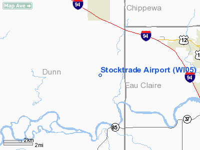
Location & QuickFacts
| FAA Information Effective: | 2008-09-25 |
| Airport Identifier: | WI05 |
| Airport Status: | Operational |
| Longitude/Latitude: | 091-41-04.0000W/44-48-30.0000N
-91.684444/44.808333 (Estimated) |
| Elevation: | 882 ft / 268.83 m (Estimated) |
| Land: | 10 acres |
| From nearest city: | 4 nautical miles S of Elk Mound, WI |
| Location: | Dunn County, WI |
| Magnetic Variation: | 01E () |
Owner & Manager
| Ownership: | Privately owned |
| Owner: | Jose M. Borja |
| Address: | E 9419 County Rd E
Elk Mound, WI 54739 |
| Phone number: | 715-874-6429 |
| Manager: | Jose M. Borja |
| Address: | E 9419 County Rd E
Elk Mound, WI 54739 |
| Phone number: | 715-874-6429 |
Airport Operations and Facilities
| Airport Use: | Private |
| Wind indicator: | Yes |
| Segmented Circle: | No |
| Control Tower: | No |
| Sectional chart: | Green Bay |
| Region: | AGL - Great Lakes |
| Boundary ARTCC: | ZMP - Minneapolis |
| Tie-in FSS: | GRB - Green Bay |
| FSS Toll Free: | 1-800-WX-BRIEF |
Runway Information
Runway 03/21
| Dimension: | 1050 x 18 ft / 320.0 x 5.5 m |
| Surface: | TURF, |
| |
Runway 03 |
Runway 21 |
| Traffic Pattern: | Left | Left |
| Displaced threshold: | 150.00 ft | 100.00 ft |
| Obstruction: | 2 ft fence, 260.0 ft from runway | 4 ft fence, 1300.0 ft from runway |
|
Radio Navigation Aids
| ID |
Type |
Name |
Ch |
Freq |
Var |
Dist |
| AHH | NDB | Ameron | | 278.00 | 01E | 40.7 nm |
| RNH | NDB | New Richmond | | 257.00 | 02E | 41.4 nm |
| UBE | NDB | Cumberland | | 375.00 | 01E | 43.9 nm |
| BCK | NDB | Black River Falls | | 362.00 | 00E | 48.9 nm |
| RPD | VOR/DME | Rice Lake | 037X | 110.00 | 01E | 36.7 nm |
| ONA | VOR/DME | Winona | 051X | 111.40 | 01E | 44.0 nm |
| EAU | VORTAC | Eau Claire | 076X | 112.90 | 04E | 10.3 nm |
Remarks
- RESTRICTED TO ACFT CAPABLE OF STOL OPNS UNDER 2000 LBS GROSS WEIGHT.
- PRVDD CLEAR 20:1 APCH SLOPE CLEAR RY SAFETY AREA AND CLEAR OBSTACLE FREE ZONE.
Images and information placed above are from
http://www.airport-data.com/airport/WI05/
We thank them for the data!
| General Info
|
| Country |
United States
|
| State |
WISCONSIN
|
| FAA ID |
WI05
|
| Latitude |
44-48-30.000N
|
| Longitude |
091-41-04.000W
|
| Elevation |
882 feet
|
| Near City |
ELK MOUND
|
We don't guarantee the information is fresh and accurate. The data may
be wrong or outdated.
For more up-to-date information please refer to other sources.
|
|


