 |
|
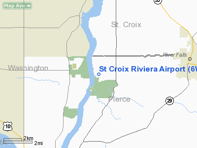
Location & QuickFacts
| FAA Information Effective: | 2008-09-25 |
| Airport Identifier: | 6WI2 |
| Airport Status: | Operational |
| Longitude/Latitude: | 092-45-20.7260W/44-50-37.8830N
-92.755757/44.843856 (Estimated) |
| Elevation: | 895 ft / 272.80 m (Estimated) |
| Land: | 0 acres |
| From nearest city: | 5 nautical miles W of River Falls, WI |
| Location: | Pierce County, WI |
| Magnetic Variation: | 03E (1985) |
Owner & Manager
| Ownership: | Privately owned |
| Owner: | Riviera Airport Inc. |
| Address: | Po Box 545
River Falls, WI 54022 |
| Phone number: | 715-425-5375 |
| Manager: | Charles Jay Hermann |
| Address: | W12480 832nd Ave
River Falls, WI 54022 |
| Phone number: | 715-425-5375 |
Airport Operations and Facilities
| Airport Use: | Private |
| Wind indicator: | Yes |
| Segmented Circle: | No |
| Control Tower: | No |
| Lighting Schedule: | RDO-CTL
ACTVT LIRL RWY NW/SE - 122.9. |
| Landing fee charge: | No |
| Sectional chart: | Green Bay |
| Region: | AGL - Great Lakes |
| Boundary ARTCC: | ZMP - Minneapolis |
| Tie-in FSS: | GRB - Green Bay |
| FSS on Airport: | No |
| FSS Toll Free: | 1-800-WX-BRIEF |
Airport Services
| Airframe Repair: | NONE |
| Power Plant Repair: | NONE |
Runway Information
Runway NW/SE
| Dimension: | 1700 x 100 ft / 518.2 x 30.5 m |
| Surface: | TURF, |
| Edge Lights: | Low |
| |
Runway NW |
Runway SE |
| Traffic Pattern: | Right | Left |
| Displaced threshold: | 0.00 ft | 650.00 ft
DSPLCD THLD MKD WITH ORANGE & WHITE MARKERS. |
| Obstruction: | 50 ft trees, 1400.0 ft from runway | 25 ft trees, 650.0 ft from runway |
|
Radio Navigation Aids
| ID |
Type |
Name |
Ch |
Freq |
Var |
Dist |
| PPI | NDB | Hopey | | 400.00 | 03E | 8.1 nm |
| MS | NDB | Narco | | 266.00 | 02E | 14.3 nm |
| RNH | NDB | New Richmond | | 257.00 | 02E | 20.5 nm |
| OEO | NDB | Osceola | | 233.00 | 01E | 28.2 nm |
| AHH | NDB | Ameron | | 278.00 | 01E | 31.0 nm |
| CBG | NDB | Cambridge | | 350.00 | 03E | 48.0 nm |
| MSP | VOR/DME | Minneapolis | 100X | 115.30 | 02E | 20.7 nm |
| FCM | VOR/DME | Flying Cloud | 055X | 111.80 | 06E | 29.9 nm |
| FOW | VOR/DME | Halfway | 049X | 111.20 | 02E | 46.6 nm |
| FGT | VORTAC | Farmington | 104X | 115.70 | 06E | 22.3 nm |
| GEP | VORTAC | Gopher | 120X | 117.30 | 06E | 31.9 nm |
| STP | VOT | St Paul | | 114.40 | | 14.2 nm |
| MSP | VOT | Minneapolis St Paul | | 111.00 | | 19.7 nm |
Remarks
- SPECIAL OPRG PROCEDURES ARE IN EFFECT DUE TO THE PROXIMITY TO THE ST CROIX NATL SCENIC RIVERWAY. ACFT OPNS IN THE 1400 FT GRASS AREA BYD THE THLD MARKERSRY NW IS PROHIBITED. HOWEVER THIS AREA IS WELL MAINTAINED AND ACFT UNDER TOW ARE PERMITTED IN THIS AREA.
Images and information placed above are from
http://www.airport-data.com/airport/6WI2/
We thank them for the data!
| General Info
|
| Country |
United States
|
| State |
WISCONSIN
|
| FAA ID |
6WI2
|
| Latitude |
44-50-37.883N
|
| Longitude |
092-45-20.726W
|
| Elevation |
895 feet
|
| Near City |
RIVER FALLS
|
We don't guarantee the information is fresh and accurate. The data may
be wrong or outdated.
For more up-to-date information please refer to other sources.
|
|


