 |
|
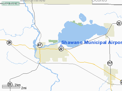
| Shawano Municipal Airport |
| IATA: none – ICAO: KEZS – FAA LID: EZS |
| Summary |
| Airport type |
Public |
| Owner |
Shawano City and County |
| Serves |
Shawano, Wisconsin |
| Elevation AMSL |
813 ft / 248 m |
| Coordinates |
44°47′14″N 088°33′36″W / 44.78722°N 88.56°W / 44.78722; -88.56 |
| Runways |
| Direction |
Length |
Surface |
| ft |
m |
| 11/29 |
3,900 |
1,189 |
Asphalt |
| 17/35 |
2,225 |
678 |
Asphalt |
| ALL/WAY |
12,000 |
3,658 |
Water |
| Statistics (2005) |
| Aircraft operations |
17,550 |
| Based aircraft |
33 |
| Source: Federal Aviation Administration |
Shawano Municipal Airport (ICAO: KEZS, FAA LID: EZS, formerly 3WO) is a public-use airport located one nautical mile (2 km) northeast of the central business district of Shawano, a city in Shawano County, Wisconsin, United States. The airport is owned by the city and county. The airport is located on Shawano Lake and has a landing area for seaplanes.
Facilities and aircraft
Shawano Municipal Airport covers an area of 295 acres (119 ha) at an elevation of 813 feet (248 m) above mean sea level. It has two asphalt paved runways: 11/29 is 3,900 by 75 feet (1,189 x 23 m) and 17/35 is 2,225 by 60 feet (678 x 18 m). The airport also has one seaplane landing area measuring 12,000 by 1,000 feet (3,658 x 305 m).
For the 12-month period ending September 22, 2005, the airport had 17,550 aircraft operations, an average of 48 per day: 94% general aviation, 4% air taxi and 2% military. At that time there were 33 aircraft based at this airport: 85% single-engine, 9% multi-engine and 6% ultralight.
The above content comes from Wikipedia and is published under free licenses – click here to read more.
Location & QuickFacts
| FAA Information Effective: | 2008-09-25 |
| Airport Identifier: | EZS |
| Airport Status: | Operational |
| Longitude/Latitude: | 088-33-36.0520W/44-47-14.3010N
-88.560014/44.787306 (Estimated) |
| Elevation: | 813 ft / 247.80 m (Surveyed) |
| Land: | 295 acres |
| From nearest city: | 1 nautical miles NE of Shawano, WI |
| Location: | Shawano County, WI |
| Magnetic Variation: | 02W (1995) |
Owner & Manager
| Ownership: | Publicly owned |
| Owner: | Shawano City And Co
CITY OF SHAWANO & CO OF SHAWANO; LARRY SPERBERG, CHRMN ARPT COMMISSIONER; 715-253-2163. |
| Address: | 311 N. Main St
Shawano, WI 54166 |
| Phone number: | 715-526-2230 |
| Manager: | Clarence Schampers |
| Address: | 248 Airport Rd
Shawano, WI 54166 |
| Phone number: | 715-526-2465 |
Airport Operations and Facilities
| Airport Use: | Open to public |
| Wind indicator: | Yes |
| Segmented Circle: | No |
| Control Tower: | No |
| Lighting Schedule: | DUSK-DAWN
ACTIVATE MIRL RYS 11/29 & 17/35 - CTAF. |
| Beacon Color: | Clear-Green (lighted land airport)
ROTG BCN LOCATED ON ARPT 1/2 MILE SW OF SEALANE. |
| Landing fee charge: | No |
| Sectional chart: | Green Bay |
| Region: | AGL - Great Lakes |
| Boundary ARTCC: | ZMP - Minneapolis |
| Tie-in FSS: | GRB - Green Bay |
| FSS on Airport: | No |
| FSS Toll Free: | 1-800-WX-BRIEF |
| NOTAMs Facility: | GRB (NOTAM-d service avaliable) |
| Federal Agreements: | NGY |
Airport Communications
| CTAF: | 122.800 |
| Unicom: | 122.800 |
Airport Services
| Fuel available: | 100LL |
| Airframe Repair: | MAJOR |
| Power Plant Repair: | MAJOR |
Runway Information
Runway 11/29
| Dimension: | 3900 x 75 ft / 1188.7 x 22.9 m |
| Surface: | ASPH, Good Condition |
| Weight Limit: | Single wheel: 17000 lbs. |
| Edge Lights: | Medium |
| |
Runway 11 |
Runway 29 |
| Longitude: | 088-34-00.3000W | 088-33-10.3500W |
| Latitude: | 44-47-21.7600N | 44-47-07.0100N |
| Elevation: | 811.00 ft | 811.00 ft |
| Alignment: | 113 | 127 |
| Traffic Pattern: | Left | Left |
| Runway End Identifier: | No | No |
| Centerline Lights: | No | No |
| Touchdown Lights: | No | No |
| Obstruction: | 15 ft road, 480.0 ft from runway, 130 ft right of centerline, 18:1 slope to clear | 67 ft trees, 1750.0 ft from runway, 100 ft right of centerline, 23:1 slope to clear |
|
Runway 17/35
| Dimension: | 2225 x 60 ft / 678.2 x 18.3 m |
| Surface: | ASPH, |
| Edge Lights: | Medium |
| |
Runway 17 |
Runway 35 |
| Longitude: | 088-33-41.3600W | 088-33-33.2900W |
| Latitude: | 44-47-24.7600N | 44-47-03.5500N |
| Elevation: | 809.00 ft | 813.00 ft |
| Alignment: | 127 | 127 |
| Traffic Pattern: | Left | Left |
|
Runway ALL/WAY
| Dimension: | 12000 x 1000 ft / 3657.6 x 304.8 m |
| Surface: | WATER, |
| |
Runway ALL |
Runway WAY |
| Traffic Pattern: | Left | Left |
|
Radio Navigation Aids
| ID |
Type |
Name |
Ch |
Freq |
Var |
Dist |
| CLI | NDB | Clintonville | | 209.00 | 02W | 12.5 nm |
| OCQ | NDB | Oconto | | 388.00 | 03W | 28.1 nm |
| SG | NDB | Depre | | 332.00 | 02W | 29.7 nm |
| AIG | NDB | Antigo | | 347.00 | 02W | 32.4 nm |
| PCZ | NDB | Waupaca | | 382.00 | 01W | 33.6 nm |
| AQ | NDB | Kooky | | 407.00 | 02W | 35.0 nm |
| FZK | NDB | Wausau | | 243.00 | 01E | 46.2 nm |
| SUE | NDB | Sturgeon Bay | | 414.00 | 03W | 48.6 nm |
| MNM | VOR/DME | Menominee | 033X | 109.60 | 00E | 45.4 nm |
| GRB | VORTAC | Green Bay | 102X | 115.50 | 01E | 20.9 nm |
| AUW | VORTAC | Wausau | 053X | 111.60 | 02E | 43.9 nm |
| STE | VORTAC | Stevens Point | 043X | 110.60 | 01W | 44.0 nm |
| OSH | VORTAC | Oshkosh | 055X | 111.80 | 02E | 47.9 nm |
Remarks
- WATERFOWL & DEER ON & INVOF ARPT.
- RY ALL/WAY SEAPLANE LANE HAS FLOATING TIE DOWNS & BEACHING RAMP.
- SEAPLANE WATERWAY CLSD EARLY NOV TO EARLY MAY, CALL AMGR 715-526-2465 FOR COND.
- GCO AVBL ON FREQ 121.725 THRU FLIGHT SVC.
Images and information placed above are from
http://www.airport-data.com/airport/EZS/
We thank them for the data!
|
|


