 |
|
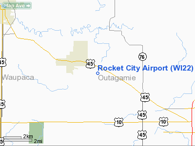
Location & QuickFacts
| FAA Information Effective: | 2008-09-25 |
| Airport Identifier: | WI22 |
| Airport Status: | Operational |
| Longitude/Latitude: | 088-36-03.0000W/44-19-23.0000N
-88.600833/44.323056 (Estimated) |
| Elevation: | 905 ft / 275.84 m (Estimated) |
| Land: | 15 acres |
| From nearest city: | 2 nautical miles ES of Hortonville, WI |
| Location: | Outagamie County, WI |
| Magnetic Variation: | 02W () |
Owner & Manager
| Ownership: | Privately owned |
| Owner: | David J. Novak/todd Douma |
| Address: | N2285 Manley Road
Hortonville, WI 54944 |
| Phone number: | 920-779-0889 |
| Manager: | David J. Novak/todd Douma |
| Address: | N2285 Manley Road
Hortonville, WI 54944 |
| Phone number: | 920-779-0889 |
Airport Operations and Facilities
| Airport Use: | Private |
| Wind indicator: | Yes |
| Segmented Circle: | No |
| Control Tower: | No |
| Sectional chart: | Green Bay |
| Region: | AGL - Great Lakes |
| Boundary ARTCC: | ZMP - Minneapolis |
| Tie-in FSS: | GRB - Green Bay |
| FSS Toll Free: | 1-800-WX-BRIEF |
Runway Information
Runway 09/27
| Dimension: | 1850 x 60 ft / 563.9 x 18.3 m |
| Surface: | TURF, |
| |
Runway 09 |
Runway 27 |
| Longitude: | 091-06-36.5100W | 091-06-01.0600W |
| Latitude: | 45-09-54.8800N | 45-09-54.8800N |
| Elevation: | 1154.00 ft | 1154.00 ft |
| Traffic Pattern: | Left | Left |
| Displaced threshold: | 650.00 ft | 650.00 ft |
| Obstruction: | 18 ft bldg, 15.0 ft from runway | 15 ft road, 50.0 ft from runway |
|
Runway 10/28
| Dimension: | 2000 x 60 ft / 609.6 x 18.3 m |
| Surface: | TURF, |
| |
Runway 10 |
Runway 28 |
| Traffic Pattern: | Left | Left |
| Displaced threshold: | 135.00 ft | 0.00 ft |
| Obstruction: | 18 ft bldg, 246.0 ft from runway | 15 ft road, 500.0 ft from runway |
|
Radio Navigation Aids
| ID |
Type |
Name |
Ch |
Freq |
Var |
Dist |
| AQ | NDB | Kooky | | 407.00 | 02W | 10.8 nm |
| PCZ | NDB | Waupaca | | 382.00 | 01W | 17.9 nm |
| CLI | NDB | Clintonville | | 209.00 | 02W | 18.7 nm |
| SG | NDB | Depre | | 332.00 | 02W | 20.6 nm |
| OCQ | NDB | Oconto | | 388.00 | 03W | 44.4 nm |
| MTW | VOR/DME | Manitowoc | 047X | 111.00 | 02W | 41.4 nm |
| FAH | VOR/DME | Falls | 37X | 110.00 | 02W | 46.5 nm |
| OSH | VORTAC | Oshkosh | 055X | 111.80 | 02E | 20.1 nm |
| GRB | VORTAC | Green Bay | 102X | 115.50 | 01E | 22.3 nm |
| STE | VORTAC | Stevens Point | 043X | 110.60 | 01W | 42.0 nm |
Remarks
- PROVIDED CLEAR OBSTACLE FREE ZONE (RR TRACKS TO THE NORTH AND WOODS MAY PENETRATE); CLEAR 20:1 APPROACHES (WOODS MAY PENETRATE); OWNERS SIGN LETTER OF AGREEMENT ON TRAFFIC PATTERNS WITH BLACK OTTER AIRPORT (TRAFFIC PATTERNS FLOWN TO THE SOUTH).
Images and information placed above are from
http://www.airport-data.com/airport/WI22/
We thank them for the data!
| General Info
|
| Country |
United States
|
| State |
WISCONSIN
|
| FAA ID |
WI22
|
| Latitude |
44-19-23.000N
|
| Longitude |
088-36-03.000W
|
| Elevation |
905 feet
|
| Near City |
HORTONVILLE
|
We don't guarantee the information is fresh and accurate. The data may
be wrong or outdated.
For more up-to-date information please refer to other sources.
|
|


