 |
|
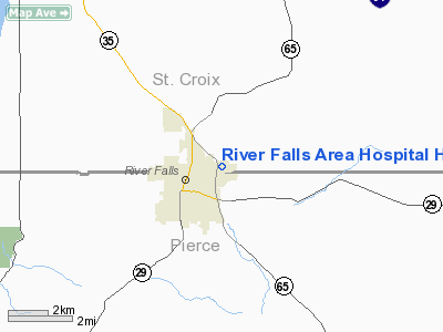
River Falls Area Hospital Heliport |
Location & QuickFacts
| FAA Information Effective: | 2008-09-25 |
| Airport Identifier: | 8WI9 |
| Airport Status: | Operational |
| Longitude/Latitude: | 092-36-10.0000W/44-51-55.0000N
-92.602778/44.865278 (Estimated) |
| Elevation: | 947 ft / 288.65 m (Estimated) |
| Land: | 0 acres |
| From nearest city: | 1 nautical miles E of River Falls, WI |
| Location: | St Croix County, WI |
| Magnetic Variation: | 02E (1990) |
Owner & Manager
| Ownership: | Privately owned |
| Owner: | River Falls Area Hospital |
| Address: | 1629 E. Division St.
River Falls, WI 54022 |
| Phone number: | 715-425-6155 |
| Manager: | Thelma Schedtler/jerry Burke |
| Address: | 1629 E. Division St.
River Falls, WI 54022 |
| Phone number: | 715-425-6155 |
Airport Operations and Facilities
| Airport Use: | Private
MEDICAL USE. |
| Segmented Circle: | No |
| Control Tower: | No |
| Sectional chart: | Chicago |
| Region: | AGL - Great Lakes |
| Boundary ARTCC: | ZMP - Minneapolis |
| Tie-in FSS: | GRB - Green Bay |
| FSS Toll Free: | 1-800-WX-BRIEF |
Runway Information
Helipad H1
| Dimension: | 50 x 50 ft / 15.2 x 15.2 m |
| Surface: | CONC, |
| |
Runway H1 |
Runway |
| Traffic Pattern: | Left | Left |
|
Radio Navigation Aids
| ID |
Type |
Name |
Ch |
Freq |
Var |
Dist |
| PPI | NDB | Hopey | | 400.00 | 03E | 14.5 nm |
| RNH | NDB | New Richmond | | 257.00 | 02E | 17.2 nm |
| MS | NDB | Narco | | 266.00 | 02E | 21.0 nm |
| AHH | NDB | Ameron | | 278.00 | 01E | 26.9 nm |
| OEO | NDB | Osceola | | 233.00 | 01E | 27.0 nm |
| UBE | NDB | Cumberland | | 375.00 | 01E | 46.9 nm |
| MSP | VOR/DME | Minneapolis | 100X | 115.30 | 02E | 27.1 nm |
| FCM | VOR/DME | Flying Cloud | 055X | 111.80 | 06E | 36.5 nm |
| RPD | VOR/DME | Rice Lake | 037X | 110.00 | 01E | 48.1 nm |
| FGT | VORTAC | Farmington | 104X | 115.70 | 06E | 28.5 nm |
| GEP | VORTAC | Gopher | 120X | 117.30 | 06E | 36.8 nm |
| EAU | VORTAC | Eau Claire | 076X | 112.90 | 04E | 47.9 nm |
| STP | VOT | St Paul | | 114.40 | | 20.0 nm |
| MSP | VOT | Minneapolis St Paul | | 111.00 | | 26.1 nm |
Remarks
- PRVDD ALL APCH/DEP OPNS FM 350-030 DEGS; FM 095-160 DEGS & FM 280-350 DEGS. THE TKOF/LDG AREA IS APPROPRIATELY MKD; A NON-OBSTRUCTING WIND INDICATOR IS MAINTAINED. TWO WAY RADIO COMMUNICATIONS BE ESTABLISHED BETWEEN THE HELICOPTER & HOSP PRIOR TO LDG.
Images and information placed above are from
http://www.airport-data.com/airport/8WI9/
We thank them for the data!
| General Info
|
| Country |
United States
|
| State |
WISCONSIN
|
| FAA ID |
8WI9
|
| Latitude |
44-51-55.000N
|
| Longitude |
092-36-10.000W
|
| Elevation |
947 feet
|
| Near City |
RIVER FALLS
|
We don't guarantee the information is fresh and accurate. The data may
be wrong or outdated.
For more up-to-date information please refer to other sources.
|
|


