 |
|
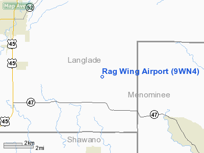
Location & QuickFacts
| FAA Information Effective: | 2008-09-25 |
| Airport Identifier: | 9WN4 |
| Airport Status: | Operational |
| Longitude/Latitude: | 089-01-47.3900W/45-05-02.3800N
-89.029831/45.083994 (Estimated) |
| Elevation: | 1500 ft / 457.20 m (Estimated) |
| Land: | 80 acres |
| From nearest city: | 9 nautical miles SE of Antigo, WI |
| Location: | Langlade County, WI |
| Magnetic Variation: | 02W (1995) |
Owner & Manager
| Ownership: | Privately owned |
| Owner: | Jeff Bell |
| Address: | N 1593 Hwy S
Antigo, WI |
| Phone number: | 715-623-5782 |
| Manager: | Jeff Bell |
| Address: | N 1593 Hwy S
Antigo, WI 54409 |
| Phone number: | 715-623-5782 |
Airport Operations and Facilities
| Airport Use: | Private |
| Segmented Circle: | No |
| Control Tower: | No |
| Sectional chart: | Green Bay |
| Region: | AGL - Great Lakes |
| Boundary ARTCC: | ZMP - Minneapolis |
| Tie-in FSS: | GRB - Green Bay |
| FSS Toll Free: | 1-800-WX-BRIEF |
Runway Information
Runway 18/36
| Dimension: | 2200 x 70 ft / 670.6 x 21.3 m |
| Surface: | TURF, |
| |
Runway 18 |
Runway 36 |
| Traffic Pattern: | Left | Left |
|
Radio Navigation Aids
| ID |
Type |
Name |
Ch |
Freq |
Var |
Dist |
| AIG | NDB | Antigo | | 347.00 | 02W | 5.7 nm |
| FZK | NDB | Wausau | | 243.00 | 01E | 27.0 nm |
| RRL | NDB | Merrill | | 257.00 | 01W | 29.4 nm |
| CLI | NDB | Clintonville | | 209.00 | 02W | 30.7 nm |
| PCZ | NDB | Waupaca | | 382.00 | 01W | 45.2 nm |
| OCQ | NDB | Oconto | | 388.00 | 03W | 49.1 nm |
| AUW | VORTAC | Wausau | 053X | 111.60 | 02E | 27.6 nm |
| RHI | VORTAC | Rhinelander | 029X | 109.20 | 02E | 37.7 nm |
| STE | VORTAC | Stevens Point | 043X | 110.60 | 01W | 38.9 nm |
| GRB | VORTAC | Green Bay | 102X | 115.50 | 01E | 47.7 nm |
Remarks
- TPA 500 FT OR LESS.
- 155 FT TOWER 2.2 MILES NE OF ARPT.
- PRVDD TPA IS 500 FT OR LESS SINCE STD 1000 FT TPA IS NOT ADEQUATE, CLEAR 20:1 APCH, AREA 125 FT EITHER SIDE OF RY & 200 FT OFF RY ENDS IS CLEAR, RY SAFETY AREA IS CLEAR OF RUTS & HAZARDS.
Images and information placed above are from
http://www.airport-data.com/airport/9WN4/
We thank them for the data!
| General Info
|
| Country |
United States
|
| State |
WISCONSIN
|
| FAA ID |
9WN4
|
| Latitude |
45-05-02.380N
|
| Longitude |
089-01-47.390W
|
| Elevation |
1500 feet
|
| Near City |
ANTIGO
|
We don't guarantee the information is fresh and accurate. The data may
be wrong or outdated.
For more up-to-date information please refer to other sources.
|
|


