 |
|
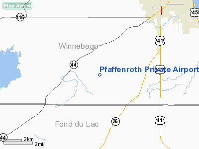
Pfaffenroth Private Airport |
Location & QuickFacts
| FAA Information Effective: | 2008-09-25 |
| Airport Identifier: | WI74 |
| Airport Status: | Operational |
| Longitude/Latitude: | 088-40-03.3990W/43-55-29.9410N
-88.667611/43.924984 (Estimated) |
| Elevation: | 872 ft / 265.79 m (Surveyed) |
| Land: | 0 acres |
| From nearest city: | 2 nautical miles S of Fisk, WI |
| Location: | Winnebago County, WI |
| Magnetic Variation: | 01W (1985) |
Owner & Manager
| Ownership: | Privately owned |
| Owner: | James R. Pfaffenroth |
| Address: | 5860 Angle Rd
Oshkosh, WI 54901 |
| Manager: | James R. Pfaffenroth |
| Address: | 5860 Angle Rd
Oshkosh, WI 54901 |
| Phone number: | 414-589-4982 |
Airport Operations and Facilities
| Airport Use: | Private |
| Wind indicator: | Yes |
| Segmented Circle: | No |
| Control Tower: | No |
| Landing fee charge: | No |
| Sectional chart: | Chicago |
| Region: | AGL - Great Lakes |
| Boundary ARTCC: | ZAU - Chicago |
| Tie-in FSS: | GRB - Green Bay |
| FSS on Airport: | No |
| FSS Toll Free: | 1-800-WX-BRIEF |
Airport Communications
Runway Information
Runway 09/27
| Dimension: | 2200 x 50 ft / 670.6 x 15.2 m |
| Surface: | TURF, |
| Edge Lights: | Low |
| |
Runway 09 |
Runway 27 |
| Traffic Pattern: | Right | Left |
|
Radio Navigation Aids
| ID |
Type |
Name |
Ch |
Freq |
Var |
Dist |
| AQ | NDB | Kooky | | 407.00 | 02W | 21.0 nm |
| PCZ | NDB | Waupaca | | 382.00 | 01W | 28.7 nm |
| UNU | NDB | Juneau | | 344.00 | 01W | 29.9 nm |
| HXF | NDB | Hartford | | 200.00 | 00E | 36.6 nm |
| SG | NDB | Depre | | 332.00 | 02W | 36.6 nm |
| LLE | NDB | Kettle Moraine | | 329.00 | 01W | 38.1 nm |
| CLI | NDB | Clintonville | | 209.00 | 02W | 41.8 nm |
| RYV | NDB | Rock River | | 371.00 | 01W | 45.2 nm |
| BJB | VOR | West Bend | | 109.80 | 01W | 38.3 nm |
| FAH | VOR/DME | Falls | 37X | 110.00 | 02W | 36.7 nm |
| MTW | VOR/DME | Manitowoc | 047X | 111.00 | 02W | 44.4 nm |
| OSH | VORTAC | Oshkosh | 055X | 111.80 | 02E | 6.2 nm |
| GRB | VORTAC | Green Bay | 102X | 115.50 | 01E | 43.0 nm |
Remarks
- RWY LGTS SET IN 20' FM EACH END OF RWY THR.
- PROVDD ALL OPERNS CONDUCTED ON S SIDE OF RWY 09/27 /ALL TURNS TO R WITH TKOF/LNDG TO E & ALL TURNS TO L WHEN TKOF/LNDG TO W.
Images and information placed above are from
http://www.airport-data.com/airport/WI74/
We thank them for the data!
| General Info
|
| Country |
United States
|
| State |
WISCONSIN
|
| FAA ID |
WI74
|
| Latitude |
43-55-29.941N
|
| Longitude |
088-40-03.399W
|
| Elevation |
872 feet
|
| Near City |
FISK
|
We don't guarantee the information is fresh and accurate. The data may
be wrong or outdated.
For more up-to-date information please refer to other sources.
|
|


