|
 |
|
||||
|
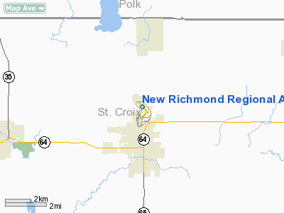
New Richmond Regional Airport (ICAO: KRNH, FAA LID: RNH) is a general aviation airport located in the city of New Richmond, Wisconsin. The airport is owned and operated by the City of New Richmond. The airport is located in western Wisconsin approximately 30 miles (48 km) northeast of Minneapolis-St. Paul. The airport is one of the fastest growing in the Midwest. Over 160 aircraft are based in privately owned hangars. The airport is home to eight aviation related businesses and several business aircraft. The airport contributes over nine million dollars per year to the New Richmond area economy. The airport serves the Eastern Twin Cities Metro Area and Western Wisconsin. New Richmond Regional Airport is the only public use airport in St. Croix County. Airport HistoryThe airport was commissioned by the FAA in July 1964 with a 3,000-foot (910 m) primary runway (Runway 13-31) and a 2,100-foot (640 m) turf runway (Runway 4-22). In 1992, a major construction project was completed. The primary runway was demolished and replaced by a new 4,003-foot (1,220 m) runway (Runway 14-32). The original hangar area located on the south end of the airport was also updated to allow additional hangars. A new aircraft parking apron was also constructed. In 1998, an additional taxilane was added to the south hangar area. The hangar area was completely filled by the end of 1998 with 45 hangars. In 2000, a new hangar area was constructed on the north end of the airport. The new area accommodated a mix of 32 small and medium sized hangars. A full-length parallel taxiway to runway 14-32 was also completed along with a small apron. In 2001, a second addition to the north aircraft parking apron was completed. In 2004, a corporate/business aviation hangar area was added to the north hangar area allowing the construction of up to seven large hangars. A third addition to the aircraft parking apron in the north hangar area was completed. An additional taxiway was also added to the north hangar area to accommodate additional private hangars. A grant from the Department of Homeland Security allowed the construction of a security fence and three automated security gates around the airport. In 2005, two new taxiway were added to the north hangar area to allow an additional 14 private and corporate hangars. In 2006, construction began on an extension to the 4,003-foot (1,220 m) primary runway and parallel taxiway to runway 14-32. The runway was completed in June 2007 and the parallel taxiway was completed in August 2007. The runway is now 5,507 feet (1,679 m) long. A helicopter landing apron and a connecting taxiway in the corporate hangar area were also completed as part of the 2006-2007 project. Picture of the airport - October 2007 [1] In 2008, the airport completed the purchase of over 60 acres (240,000 m) adjoining the north side of the airport. The land will be used for future economic development. Reconstruction of the oldest portion of the primary runway started on September 8th, along with the replacement and upgrading of the runway lighting system. Blast/over-run pads were installed on each end of the primary runway. A connecting taxiway in the corporate hangar area was also constructed. The runway was reopened for operations on October 4th. http://www.nrairport.com/2008%20Airport%20Construction.htm for construction photos. In 2010, a taxiway, taxilane, and access road serving the northeast side of the airport was completed. The project provided the necessary infrastructure for future aviation-related businesses. Additional security fencing and gates were also part of the 2010 project. Airport BusinessesBaumann Floats, Griggs Aviation, RC Avionics, New Richmond Aero, Proto Type Machine / Aerospace Hydraulics, Mike Demulling Flight Instruction, J&A Aero, Hertz Local Edition Airport OperationsThe airport is funded from lease fees for hangar lots and taxes on the hangars. No additional non airport produced funds are used to operate the airport. Airport WeatherThe airport has an on-site Automated Weather Observation Station (AWOS) providing continuous aviation weather METAR reports. In the event of an AWOS outage, manual weather observations are recorded by trained weather observers. In August 2006, the National Weather Service in Chanhassen, MN began issuing Terminal Aerodrome Forecasts (TAF) for New Richmond Regional Airport. The current TAF can be found at [2] The current METAR report can be found at [3] Instrument ApproachesThe airport has two GPS / RNAV approaches and a non-directional beacon (NDB) approach. Precision LPV GPS approaches are under development. Air ShowsAir shows were held each June from 2004 through 2007. No air show was held in 2008 due to various on-going airport construction projects. In 2009, the air show was converted into a fly-in event. Pictures from previous air shows can be found at: [4] The above content comes from Wikipedia and is published under free licenses – click here to read more.
Location & QuickFacts
Owner & Manager
Airport Operations and Facilities
Airport Communications
Airport Services
Runway InformationRunway 04/22
Runway 14/32
Radio Navigation Aids
Remarks
Images and information placed above are from We thank them for the data!
We don't guarantee the information is fresh and accurate. The data may
be wrong or outdated.
|
|||||||||||||||||||||||||||||||||||||||||||||||||||||||||||||||||||||||||||||||||||||||||||||||||||||||||||||||||||||||||||||||||||||||||||||||||||||||||||||||||||||||||||||||||||||||||||||||||||||||||||||||||||||||||||||||||||||||||||||||||||||||||||||||||||||||||||||||||||||||||||||||||||||||||||||||||||||||||||||||||||||||||||||||||||||||||||||||||||||||||||||||||||||||||||||||||||||||||||||||||||||||||||||||

 |
|
Copyright 2004-2026 © by Airports-Worldwide.com, Vyshenskoho st. 36, Lviv 79010, Ukraine Legal Disclaimer |