 |
|
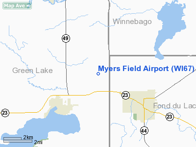
Location & QuickFacts
| FAA Information Effective: | 2008-09-25 |
| Airport Identifier: | WI67 |
| Airport Status: | Operational |
| Longitude/Latitude: | 088-54-02.4050W/43-52-35.9340N
-88.900668/43.876648 (Estimated) |
| Elevation: | 935 ft / 284.99 m (Estimated) |
| Land: | 10 acres |
| From nearest city: | 3 nautical miles NW of Ripon, WI |
| Location: | Green Lake County, WI |
| Magnetic Variation: | 00W (1990) |
Owner & Manager
| Ownership: | Privately owned |
| Owner: | Keith & Carol Myers |
| Address: | N6698 County Rd Pp
Ripon, WI |
| Phone number: | 920-748-3736 |
| Manager: | Keith & Carol Myers |
| Address: | N6698 County Rd Pp
Ripon, WI |
| Phone number: | 920-748-3736 |
Airport Operations and Facilities
| Airport Use: | Private |
| Wind indicator: | Yes |
| Segmented Circle: | No |
| Control Tower: | No |
| Sectional chart: | Chicago |
| Region: | AGL - Great Lakes |
| Boundary ARTCC: | ZAU - Chicago |
| Tie-in FSS: | GRB - Green Bay |
| FSS on Airport: | No |
| FSS Toll Free: | 1-800-WX-BRIEF |
Airport Communications
Runway Information
Runway 09/27
| Dimension: | 2500 x 100 ft / 762.0 x 30.5 m |
| Surface: | TURF, |
| |
Runway 09 |
Runway 27 |
| Traffic Pattern: | Left | Left |
|
Radio Navigation Aids
| ID |
Type |
Name |
Ch |
Freq |
Var |
Dist |
| PCZ | NDB | Waupaca | | 382.00 | 01W | 27.8 nm |
| UNU | NDB | Juneau | | 344.00 | 01W | 28.3 nm |
| AQ | NDB | Kooky | | 407.00 | 02W | 29.8 nm |
| HXF | NDB | Hartford | | 200.00 | 00E | 38.6 nm |
| RYV | NDB | Rock River | | 371.00 | 01W | 42.9 nm |
| LLE | NDB | Kettle Moraine | | 329.00 | 01W | 43.2 nm |
| CLI | NDB | Clintonville | | 209.00 | 02W | 45.2 nm |
| SG | NDB | Depre | | 332.00 | 02W | 45.6 nm |
| ISW | NDB | Wisconsin Rapids | | 215.00 | 01W | 50.0 nm |
| BJB | VOR | West Bend | | 109.80 | 01W | 43.4 nm |
| FAH | VOR/DME | Falls | 37X | 110.00 | 02W | 46.1 nm |
| OSH | VORTAC | Oshkosh | 055X | 111.80 | 02E | 16.4 nm |
| DLL | VORTAC | Dells | 117X | 117.00 | 03E | 42.3 nm |
| MSN | VORTAC | Madison | 023X | 108.60 | 03E | 48.0 nm |
| STE | VORTAC | Stevens Point | 043X | 110.60 | 01W | 48.4 nm |
Images and information placed above are from
http://www.airport-data.com/airport/WI67/
We thank them for the data!
| General Info
|
| Country |
United States
|
| State |
WISCONSIN
|
| FAA ID |
WI67
|
| Latitude |
43-52-35.934N
|
| Longitude |
088-54-02.405W
|
| Elevation |
935 feet
|
| Near City |
RIPON
|
We don't guarantee the information is fresh and accurate. The data may
be wrong or outdated.
For more up-to-date information please refer to other sources.
|
|


