 |
|
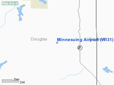
Location & QuickFacts
| FAA Information Effective: | 2008-09-25 |
| Airport Identifier: | WI31 |
| Airport Status: | Operational |
| Longitude/Latitude: | 091-39-03.6820W/46-24-51.7910N
-91.651023/46.414386 (Estimated) |
| Elevation: | 1207 ft / 367.89 m (Estimated) |
| Land: | 20 acres |
| From nearest city: | 7 nautical miles SE of Lake Nebagamon, WI |
| Location: | Douglas County, WI |
| Magnetic Variation: | 01E (1985) |
Owner & Manager
| Ownership: | Privately owned |
| Owner: | Degerman Field Llc |
| Address: | Attn: Legal Dept, 301 Carlson Pkwy Suite 100
Minnetonka, MN 55305 |
| Phone number: | 952-404-5000 |
| Manager: | Minnesuing Lodge Manager |
| Address: | 8084 S. Minnesuing Acres Dr
Lake Nebagamon, WI 54849 |
| Phone number: | 715-374-2262 |
Airport Operations and Facilities
| Airport Use: | Private |
| Wind indicator: | Yes |
| Segmented Circle: | No |
| Control Tower: | No |
| Beacon Color: | Clear-Green (lighted land airport) |
| Sectional chart: | Green Bay |
| Region: | AGL - Great Lakes |
| Traffic Pattern Alt: | 1000 ft |
| Boundary ARTCC: | ZMP - Minneapolis |
| Tie-in FSS: | GRB - Green Bay |
| FSS on Airport: | No |
| FSS Toll Free: | 1-800-WX-BRIEF |
Airport Services
Runway Information
Runway 18/36
| Dimension: | 5300 x 75 ft / 1615.4 x 22.9 m |
| Surface: | ASPH, Fair Condition |
| |
Runway 18 |
Runway 36 |
| Longitude: | 088-29-40.6200W | 088-29-38.1400W |
| Latitude: | 45-17-45.9400N | 45-17-29.8400N |
| Elevation: | 1229.00 ft | 1230.00 ft |
| Traffic Pattern: | Left | Left |
| Markings: | Nonstandard, | Nonstandard, |
| Displaced threshold: | 305.00 ft | 305.00 ft |
| Runway End Identifier: | No | No |
| Centerline Lights: | No | No |
| Touchdown Lights: | No | No |
| Obstruction: |
+40' TREES. | 20 ft trees, 200.0 ft from runway
+40' TREES. |
|
Radio Navigation Aids
| ID |
Type |
Name |
Ch |
Freq |
Var |
Dist |
| OLG | NDB | Solon Springs | | 388.00 | 01E | 8.9 nm |
| SLY | NDB | Seeley | | 344.00 | 01E | 21.3 nm |
| SUW | NDB | Bong | | 260.00 | 01E | 25.0 nm |
| ENY | NDB | Kennedy | | 254.00 | 02E | 31.6 nm |
| TWM | NDB | Two Harbors | | 243.00 | 01E | 38.5 nm |
| DL | NDB | Pykla | | 379.00 | 02E | 38.9 nm |
| COQ | NDB | Cloquet | | 335.00 | 03E | 39.1 nm |
| SSQ | NDB | Shell Lake | | 212.00 | 01E | 42.8 nm |
| BXR | NDB | Big Doctor | | 203.00 | 02E | 46.5 nm |
| MZH | NDB | Moose Lake | | 362.00 | 02E | 47.8 nm |
| LKI | TACAN | Lakeside | 011X | | 05E | 34.0 nm |
| HYR | VOR/DME | Hayward | 081X | 113.40 | 03E | 25.2 nm |
| ASX | VOR/DME | Ashland | 039X | 110.20 | 02E | 31.4 nm |
| RZN | VOR/DME | Siren | 031X | 109.40 | 02E | 46.7 nm |
| DLH | VORTAC | Duluth | 073X | 112.60 | 05E | 32.6 nm |
Remarks
- OWNER DESIRES ARPT NOT BE CHARTED.
Images and information placed above are from
http://www.airport-data.com/airport/WI31/
We thank them for the data!
| General Info
|
| Country |
United States
|
| State |
WISCONSIN
|
| FAA ID |
WI31
|
| Latitude |
46-24-51.791N
|
| Longitude |
091-39-03.682W
|
| Elevation |
1207 feet
|
| Near City |
LAKE NEBAGAMON
|
We don't guarantee the information is fresh and accurate. The data may
be wrong or outdated.
For more up-to-date information please refer to other sources.
|
|


