 |
|
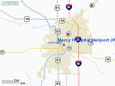
Location & QuickFacts
| FAA Information Effective: | 2008-09-25 |
| Airport Identifier: | WS40 |
| Airport Status: | Operational |
| Longitude/Latitude: | 089-01-57.4010W/42-41-18.0370N
-89.032611/42.688344 (Estimated) |
| Elevation: | 840 ft / 256.03 m (Estimated) |
| Land: | 0 acres |
| From nearest city: | 1 nautical miles N of Janesville, WI |
| Location: | Rock County, WI |
| Magnetic Variation: | 00E (1985) |
Owner & Manager
| Ownership: | Privately owned |
| Owner: | Mercy Hospital |
| Address: | 1000 Mineral Point Ave
Janesville, WI 53545 |
| Phone number: | 608-756-6000 |
| Manager: | Javon R. Bea |
| Address: | 1000 Mineral Point Ave
Janesville, WI 53545 |
| Phone number: | 608-756-6000 |
Airport Operations and Facilities
| Airport Use: | Private
MEDICAL USE. |
| Wind indicator: | Yes |
| Segmented Circle: | No |
| Control Tower: | No |
| Lighting Schedule: | DUSK-DAWN |
| Beacon Color: | Clear-Green-Yellow (heliport) |
| Sectional chart: | Chicago |
| Region: | AGL - Great Lakes |
| Boundary ARTCC: | ZAU - Chicago |
| Tie-in FSS: | GRB - Green Bay |
| FSS Toll Free: | 1-800-WX-BRIEF |
Runway Information
Helipad H1
| Dimension: | 50 x 50 ft / 15.2 x 15.2 m |
| Surface: | ASPH, |
| |
Runway H1 |
Runway |
| Traffic Pattern: | Left | Left |
| Markings: | Basic, | , |
|
Radio Navigation Aids
| ID |
Type |
Name |
Ch |
Freq |
Var |
Dist |
| JVL | NDB | Janesville | | 375.00 | 03E | 4.4 nm |
| LVV | NDB | Lake Lawn | | 404.00 | 00W | 19.4 nm |
| MS | NDB | Monah | | 400.00 | 00E | 26.4 nm |
| RYV | NDB | Rock River | | 371.00 | 01W | 32.2 nm |
| FEP | NDB | Freeport | | 335.00 | 00E | 36.2 nm |
| UES | NDB | Waukesha | | 359.00 | 01W | 41.1 nm |
| GM | NDB | Teels | | 242.00 | 02W | 45.7 nm |
| UNU | NDB | Juneau | | 344.00 | 01W | 46.8 nm |
| DKB | NDB | Dekalb | | 209.00 | 02W | 47.6 nm |
| HXF | NDB | Hartford | | 200.00 | 00E | 48.5 nm |
| JVL | VOR/DME | Janesville | 090X | 114.30 | 03E | 8.5 nm |
| RFD | VOR/DME | Rockford | 045X | 110.80 | 01E | 28.8 nm |
| BUU | VOR/DME | Burbun | 092X | 114.50 | 01W | 32.3 nm |
| PLL | VOR/DME | Polo | 049X | 111.20 | 03E | 48.6 nm |
| ENW | VOR/DME | Kenosha | 029X | 109.20 | 02W | 49.0 nm |
| MSN | VORTAC | Madison | 023X | 108.60 | 03E | 30.6 nm |
| BAE | VORTAC | Badger | 111X | 116.40 | 02E | 41.8 nm |
Remarks
- PRVDD ALL APCH/DEP OPNS 040-080 DEGS & 220-260 DEGS; TAKEOFF/LDG AREA APPROPRIATELY MKD; NON-OBSTRUCTING WIND INDICATOR MAINTAINED.
Images and information placed above are from
http://www.airport-data.com/airport/WS40/
We thank them for the data!
| General Info
|
| Country |
United States
|
| State |
WISCONSIN
|
| FAA ID |
WS40
|
| Latitude |
42-41-18.037N
|
| Longitude |
089-01-57.401W
|
| Elevation |
840 feet
|
| Near City |
JANESVILLE
|
We don't guarantee the information is fresh and accurate. The data may
be wrong or outdated.
For more up-to-date information please refer to other sources.
|
|


