 |
|
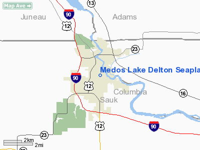
Medos Lake Delton Seaplane Base Airport |
Location & QuickFacts
| FAA Information Effective: | 2008-09-25 |
| Airport Identifier: | 9WN6 |
| Airport Status: | Operational |
| Longitude/Latitude: | 089-46-39.4480W/43-36-24.9270N
-89.777624/43.606924 (Estimated) |
| Elevation: | 832 ft / 253.59 m (Estimated) |
| Land: | 0 acres |
| From nearest city: | 1 nautical miles NE of Lake Delton/wi Dells, WI |
| Location: | Sauk County, WI |
| Magnetic Variation: | 00E (1985) |
Owner & Manager
| Ownership: | Privately owned |
| Owner: | Patrick G. Medo |
| Address: | 1300 East Hiawatha Dr
Wisconsin Dells, WI 53965 |
| Phone number: | 608-254-2248 |
| Address: |
|
| Phone number: | 608-254-2248 |
Airport Operations and Facilities
| Airport Use: | Private |
| Wind indicator: | Yes |
| Segmented Circle: | No |
| Control Tower: | No |
| Landing fee charge: | No |
| Sectional chart: | Chicago |
| Region: | AGL - Great Lakes |
| Boundary ARTCC: | ZAU - Chicago |
| Tie-in FSS: | GRB - Green Bay |
| FSS on Airport: | No |
| FSS Toll Free: | 1-800-WX-BRIEF |
Airport Services
| Fuel available: | 80
|
| Airframe Repair: | MINOR |
| Power Plant Repair: | MINOR |
Runway Information
Runway ALL/WAY
| Dimension: | 6000 x 4000 ft / 1828.8 x 1219.2 m |
| Surface: | WATER, |
| |
Runway ALL |
Runway WAY |
| Traffic Pattern: | Left | Left |
|
Radio Navigation Aids
| ID |
Type |
Name |
Ch |
Freq |
Var |
Dist |
| HBW | NDB | Kickapoo | | 251.00 | 03E | 24.3 nm |
| MS | NDB | Monah | | 400.00 | 00E | 37.8 nm |
| CMY | NDB | Mccoy | | 412.00 | 00E | 42.5 nm |
| ISW | NDB | Wisconsin Rapids | | 215.00 | 01W | 45.6 nm |
| MRJ | NDB | Mineral Point | | 365.00 | 00W | 47.5 nm |
| UNU | NDB | Juneau | | 344.00 | 01W | 48.1 nm |
| VOK | TACAN | Volk | 041X | | 00E | 29.1 nm |
| LNR | VOR/DME | Lone Rock | 075X | 112.80 | 00E | 24.4 nm |
| DLL | VORTAC | Dells | 117X | 117.00 | 03E | 3.4 nm |
| MSN | VORTAC | Madison | 023X | 108.60 | 03E | 33.7 nm |
Remarks
Images and information placed above are from
http://www.airport-data.com/airport/9WN6/
We thank them for the data!
| General Info
|
| Country |
United States
|
| State |
WISCONSIN
|
| FAA ID |
9WN6
|
| Latitude |
43-36-24.927N
|
| Longitude |
089-46-39.448W
|
| Elevation |
832 feet
|
| Near City |
LAKE DELTON/WI DELLS
|
We don't guarantee the information is fresh and accurate. The data may
be wrong or outdated.
For more up-to-date information please refer to other sources.
|
|


