 |
|
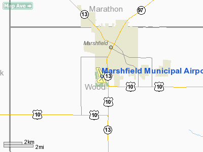
| Marshfield Municipal Airport |
| IATA: MFI – ICAO: KMFI – FAA LID: MFI |
| Summary |
| Owner/Operator |
City of Marshfield |
| Location |
Marshfield, Wisconsin |
| Elevation AMSL |
1,277 ft / 389.2 m |
| Coordinates |
44°38.213′N 090°11.3596′W / 44.636883°N 90.1893267°W / 44.636883; -90.1893267Coordinates: 44°38.213′N 090°11.3596′W / 44.636883°N 90.1893267°W / 44.636883; -90.1893267 |
| Runways |
| Direction |
Length |
Surface |
| ft |
m |
| 16/34 |
5,000 |
1,524 |
Asphalt |
| 4/22 |
3,600 |
1,097 |
Asphalt |
| Statistics (2005) |
| Operations |
26,050 |
| Based A/C |
32 |
| Stats for 12 months ending June 22, 2005 |
Marshfield Municipal Airport (IATA: MFI, ICAO: KMFI, FAA LID: MFI) is a public airport located in Marshfield, Wisconsin.
Facilities
- Runway 16/34 5,000 x 100 ft. (1,524 x 30 m), asphalt, SDF equipped
- Runway 4/22 3,600 x 100 ft. (1,097 x 30 m), asphalt
- There are two non-directional beacons associated with the airport. Marshfield NDB (MFI), 391 kHz is located on field and Marshfield LOM (ident DU), 266 kHz, is located at the outer marker marking the CALIN intersection and is used as the Initial Approach Fix for the SDF procedure on runway 34.
The above content comes from Wikipedia and is published under free licenses – click here to read more.
Location & QuickFacts
| FAA Information Effective: | 2008-09-25 |
| Airport Identifier: | MFI |
| Airport Status: | Operational |
| Longitude/Latitude: | 090-11-21.5760W/44-38-12.7670N
-90.189327/44.636880 (Estimated) |
| Elevation: | 1277 ft / 389.23 m (Surveyed) |
| Land: | 552 acres |
| From nearest city: | 1 nautical miles S of Marshfield, WI |
| Location: | Wood County, WI |
| Magnetic Variation: | 00E (1995) |
Owner & Manager
| Ownership: | Publicly owned |
| Owner: | City Of Marshfield |
| Address: | P.o. Box 727
Marshfield, WI 54449-0727 |
| Phone number: | 715-384-2919 |
| Manager: | Harold Gaier |
| Address: | 210 W 29th St
Marshfield, WI 54449 |
| Phone number: | 715-387-2211 |
Airport Operations and Facilities
| Airport Use: | Open to public |
| Wind indicator: | Yes |
| Segmented Circle: | Yes |
| Control Tower: | No |
| Lighting Schedule: | DUSK-DAWN
ACTVT MIRL RYS 04/22 & 16/34, MALSR RY 34 AND VASI RYS 16 & 34 - CTAF. PAPI RY 04 OPERS CONT. |
| Beacon Color: | Clear-Green (lighted land airport)
OTS INDEFLY. |
| Landing fee charge: | No |
| Sectional chart: | Green Bay |
| Region: | AGL - Great Lakes |
| Boundary ARTCC: | ZMP - Minneapolis |
| Tie-in FSS: | GRB - Green Bay |
| FSS on Airport: | No |
| FSS Toll Free: | 1-800-WX-BRIEF |
| NOTAMs Facility: | MFI (NOTAM-d service avaliable) |
| Federal Agreements: | NGY |
Airport Communications
| CTAF: | 123.000 |
| Unicom: | 123.000 |
Airport Services
| Fuel available: | 100LLA |
| Airframe Repair: | MAJOR |
| Power Plant Repair: | MINOR |
| Bottled Oxygen: | NONE |
| Bulk Oxygen: | NONE |
Runway Information
Runway 04/22
| Dimension: | 3600 x 100 ft / 1097.3 x 30.5 m |
| Surface: | ASPH, Good Condition |
| Weight Limit: | Single wheel: 35000 lbs.
Dual wheel: 45000 lbs. |
| Edge Lights: | Medium |
| |
Runway 04 |
Runway 22 |
| Longitude: | 090-11-33.1030W | 090-10-56.9830W |
| Latitude: | 44-37-55.2870N | 44-38-19.7470N |
| Elevation: | 1252.00 ft | 1248.00 ft |
| Alignment: | 47 | 127 |
| Traffic Pattern: | Right | Left |
| Markings: | Non-precision instrument, Good Condition | Non-precision instrument, Good Condition |
| Crossing Height: | 29.00 ft | 0.00 ft |
| VASI: | 2-light PAPI on left side | |
| Visual Glide Angle: | 3.00° | 0.00° |
| Runway End Identifier: | Yes | |
| Centerline Lights: | No | No |
| Touchdown Lights: | No | No |
| Obstruction: | , 50:1 slope to clear | 24 ft pole, 690.0 ft from runway, 230 ft left of centerline, 20:1 slope to clear |
|
Runway 16/34
| Dimension: | 5000 x 100 ft / 1524.0 x 30.5 m |
| Surface: | ASPH, Good Condition |
| Weight Limit: | Single wheel: 35000 lbs.
Dual wheel: 50000 lbs. |
| Edge Lights: | Medium |
| |
Runway 16 |
Runway 34 |
| Longitude: | 090-11-38.9270W | 090-11-13.6530W |
| Latitude: | 44-38-39.6030N | 44-37-53.6420N |
| Elevation: | 1277.00 ft | 1254.00 ft |
| Alignment: | 127 | 127 |
| ILS Type: | | SDF
|
| Traffic Pattern: | Right | Left |
| Markings: | Non-precision instrument, Fair Condition | Non-precision instrument, Fair Condition |
| Crossing Height: | 35.00 ft | 42.00 ft |
| VASI: | 2-box on left side | 2-box on left side |
| Visual Glide Angle: | 3.00° | 3.00° |
| Approach lights: | | MALSR |
| Runway End Identifier: | Yes | No |
| Centerline Lights: | No | No |
| Touchdown Lights: | No | No |
| Obstruction: | 42 ft trees, 2000.0 ft from runway, 350 ft left of centerline, 42:1 slope to clear | , 50:1 slope to clear |
|
Radio Navigation Aids
| ID |
Type |
Name |
Ch |
Freq |
Var |
Dist |
| MFI | NDB | Marshfield | | 391.00 | 00E | 0.3 nm |
| VIQ | NDB | Neillsville | | 368.00 | 01W | 14.7 nm |
| ISW | NDB | Wisconsin Rapids | | 215.00 | 01W | 22.2 nm |
| MDZ | NDB | Medford | | 335.00 | 00E | 28.6 nm |
| FZK | NDB | Wausau | | 243.00 | 01E | 29.7 nm |
| BCK | NDB | Black River Falls | | 362.00 | 00E | 36.5 nm |
| RRL | NDB | Merrill | | 257.00 | 01W | 39.6 nm |
| CMY | NDB | Mccoy | | 412.00 | 00E | 46.3 nm |
| VOK | TACAN | Volk | 041X | | 00E | 41.8 nm |
| AUW | VORTAC | Wausau | 053X | 111.60 | 02E | 28.7 nm |
| STE | VORTAC | Stevens Point | 043X | 110.60 | 01W | 28.8 nm |
Remarks
- BIRDS, WATERFOWL & DEER ON & INVOF ARPT.
- RY 34 DEPARTING ACFT CLIMB TO 2000 FT MSL PRIOR TO INITIATING RIGHT TURN.
Images and information placed above are from
http://www.airport-data.com/airport/MFI/
We thank them for the data!
| General Info
|
| Country |
United States
|
| State |
WISCONSIN
|
| FAA ID |
MFI
|
| Latitude |
44-38-12.767N
|
| Longitude |
090-11-21.576W
|
| Elevation |
1277 feet
|
| Near City |
MARSHFIELD
|
We don't guarantee the information is fresh and accurate. The data may
be wrong or outdated.
For more up-to-date information please refer to other sources.
|
|


