 |
|
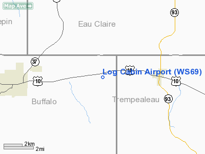
Location & QuickFacts
| FAA Information Effective: | 2008-09-25 |
| Airport Identifier: | WS69 |
| Airport Status: | Operational |
| Longitude/Latitude: | 091-32-49.5600W/44-34-29.8700N
-91.547100/44.574964 (Estimated) |
| Elevation: | 850 ft / 259.08 m (Estimated) |
| Land: | 0 acres |
| From nearest city: | 4 nautical miles W of Eleva, WI |
| Location: | Buffalo County, WI |
| Magnetic Variation: | 02E (1990) |
Owner & Manager
| Ownership: | Privately owned |
| Owner: | Douglas J. Ward |
| Address: | S149 Segerstrom Road
Mondovi, WI 54755 |
| Phone number: | 715-287-4205 |
| Manager: | Douglas J. Ward |
| Address: | S149 Segerstrom Road
Mondovi, WI 54755 |
| Phone number: | 715-287-4205 |
Airport Operations and Facilities
| Airport Use: | Private |
| Segmented Circle: | No |
| Control Tower: | No |
| Sectional chart: | Green Bay |
| Region: | AGL - Great Lakes |
| Boundary ARTCC: | ZMP - Minneapolis |
| Tie-in FSS: | GRB - Green Bay |
| FSS Toll Free: | 1-800-WX-BRIEF |
Runway Information
Runway 09/27
| Dimension: | 1300 x 75 ft / 396.2 x 22.9 m |
| Surface: | TURF, |
| |
Runway 09 |
Runway 27 |
| Traffic Pattern: | Left | Left |
|
Runway 18/36
| Dimension: | 2500 x 60 ft / 762.0 x 18.3 m |
| Surface: | TURF, |
| |
Runway 18 |
Runway 36 |
| Traffic Pattern: | Left | Left |
|
Radio Navigation Aids
| ID |
Type |
Name |
Ch |
Freq |
Var |
Dist |
| BCK | NDB | Black River Falls | | 362.00 | 00E | 35.6 nm |
| VIQ | NDB | Neillsville | | 368.00 | 01W | 44.2 nm |
| ONA | VOR/DME | Winona | 051X | 111.40 | 01E | 30.7 nm |
| LSE | VOR/DME | La Crosse | 021X | 108.40 | 02E | 43.8 nm |
| EAU | VORTAC | Eau Claire | 076X | 112.90 | 04E | 19.6 nm |
| ODI | VORTAC | Nodine | 126X | 117.90 | 01E | 40.0 nm |
Remarks
- NEW RY 18/36 PER AIRSPACE CASE 2002-AGL-703-NRA.
Images and information placed above are from
http://www.airport-data.com/airport/WS69/
We thank them for the data!
| General Info
|
| Country |
United States
|
| State |
WISCONSIN
|
| FAA ID |
WS69
|
| Latitude |
44-34-29.870N
|
| Longitude |
091-32-49.560W
|
| Elevation |
850 feet
|
| Near City |
ELEVA
|
We don't guarantee the information is fresh and accurate. The data may
be wrong or outdated.
For more up-to-date information please refer to other sources.
|
|


